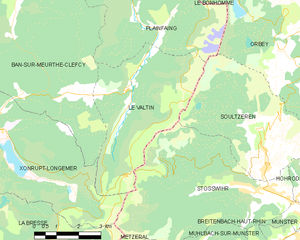
Xonrupt-Longemer (Xonrupt-Longemer)
- commune in Vosges, France
- Country:

- Postal Code: 88400
- Coordinates: 48° 4' 50" N, 6° 55' 33" E


- GPS tracks (wikiloc): [Link]
- Area: 30.71 sq km
- Population: 1541
- Web site: http://www.xonrupt.fr
- Wikipedia en: wiki(en)
- Wikipedia: wiki(fr)
- Wikidata storage: Wikidata: Q520997
- Wikipedia Commons Category: [Link]
- Freebase ID: [/m/03qgvry]
- GeoNames ID: Alt: [2967263]
- SIREN number: [218805315]
- BnF ID: [15279450g]
- VIAF ID: Alt: [145742792]
- Library of Congress authority ID: Alt: [no99052139]
- MusicBrainz area ID: [1d1c3903-6c4e-42ba-ad9e-44549992cbef]
- INSEE municipality code: 88531
Shares border with regions:


Ban-sur-Meurthe-Clefcy
- commune in Vosges, France
- Country:

- Postal Code: 88230
- Coordinates: 48° 10' 21" N, 6° 58' 45" E


- GPS tracks (wikiloc): [Link]
- Area: 45.04 sq km
- Population: 966
- Web site: [Link]


Gérardmer
- commune in Vosges, France
- Country:

- Postal Code: 88400
- Coordinates: 48° 4' 20" N, 6° 52' 43" E


- GPS tracks (wikiloc): [Link]
- AboveSeaLevel: 670 м m
- Area: 54.78 sq km
- Population: 8294
- Web site: [Link]


Stosswihr
- commune in Haut-Rhin, France
- Country:

- Postal Code: 68140
- Coordinates: 48° 3' 14" N, 7° 6' 15" E


- GPS tracks (wikiloc): [Link]
- Area: 26.4 sq km
- Population: 1344


La Bresse
- commune in Vosges, France
- Country:

- Postal Code: 88250
- Coordinates: 48° 0' 21" N, 6° 52' 33" E


- GPS tracks (wikiloc): [Link]
- Area: 57.94 sq km
- Population: 4243
- Web site: [Link]


Gerbépal
- commune in Vosges, France
- Country:

- Postal Code: 88430
- Coordinates: 48° 9' 0" N, 6° 55' 19" E


- GPS tracks (wikiloc): [Link]
- Area: 19.18 sq km
- Population: 583
- Web site: [Link]


Le Valtin
- commune in Vosges, France
- Country:

- Postal Code: 88230
- Coordinates: 48° 5' 53" N, 7° 1' 25" E


- GPS tracks (wikiloc): [Link]
- Area: 19.64 sq km
- Population: 81
