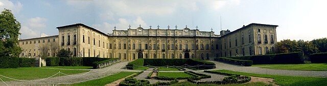
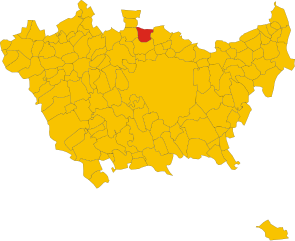
Garbagnate Milanese (Garbagnate Milanese)
.svg)
- Italian comune
 Hiking in Garbagnate Milanese
Garbagnate Milanese, located in the Lombardy region of Italy, offers a unique blend of urban and natural experiences for hikers. While it's not as mountainous as some other parts of Lombardy, there are several green spaces and trails that cater to various hiking levels.
Hiking Opportunities:
-
Parco delle Groane: This natural park, located just a short distance from Garbagnate Milanese, is one of the main hiking attractions in the area. It features a network of trails through woodlands, wetlands, and meadows, perfect for nature walks. It's a great place for birdwatching as well. The park is relatively flat, making it suitable for families and casual hikers.
-
Cerro di Garbagnate: This small hill offers a scenic viewpoint of the surrounding area. While the hike up Cerro isn't strenuous, it provides a lovely opportunity to enjoy panoramic views of the landscape, especially during sunset.
-
Via dei Sassi: This is an interesting trail that leads away from Garbagnate Milanese, featuring a mix of natural scenery and historical elements. Along the way, you might encounter quaint villages and unique rock formations.
-
Lombardy Trails: Garbagnate is well-connected to the greater Lombardy hiking trail network. You can access a variety of more challenging hikes from here, leading to areas with more diverse terrain.
Tips for Hiking in Garbagnate Milanese:
- Stay Hydrated: Even on shorter hikes, it’s important to carry enough water, especially during warmer months.
- Suitable Footwear: Make sure to wear comfortable and sturdy footwear as some trails might be uneven or muddy.
- Respect Nature: Follow Leave No Trace principles to keep the trails and parks clean for everyone.
- Check Weather Conditions: The weather can change rapidly, so it's advisable to check the forecast before heading out.
Transportation and Accessibility:
Garbagnate Milanese is well connected by public transit, including trains and buses from Milan, making it an easy day trip for those in the city. Once you arrive, most of the hiking spots are easily reachable on foot or a short drive.
Conclusion:
Whether you're a local or a visitor, Garbagnate Milanese offers accessible hiking opportunities that showcase the region's natural beauty. It’s a perfect spot for leisurely walks, family outings, and getting a breath of fresh air without having to travel far from urban comforts. Enjoy your hike!
- Country:

- Postal Code: 20024
- Local Dialing Code: 02
- Licence Plate Code: MI
- Coordinates: 45° 35' 0" N, 9° 4' 0" E


- GPS tracks (wikiloc): [Link]
- AboveSeaLevel: 179 м m
- Area: 9 sq km
- Population: 27226
- Web site: http://www.comune.garbagnate-milanese.mi.it
- Wikipedia en: wiki(en)
- Wikipedia: wiki(it)
- Wikidata storage: Wikidata: Q42291
- Wikipedia Commons Category: [Link]
- Freebase ID: [/m/0gj60r]
- GeoNames ID: Alt: [6540336]
- VIAF ID: Alt: [266169543]
- OSM relation ID: [45360]
- MusicBrainz area ID: [50bdd2fb-e29e-4909-b6df-9376f64af9b8]
- Quora topic ID: [Garbagnate-Milanese]
- UN/LOCODE: [ITGRB]
- ISTAT ID: 015105
- Italian cadastre code: D912
Shares border with regions:

Bollate
- Italian comune
Hiking in Bollate
Bollate, located in the Lombardy region of northern Italy, offers a charming setting for hiking enthusiasts. While it's not as mountainous as other areas in Italy, it serves as a gateway to several nature-rich locales and parks that can provide some delightful hiking experiences....
- Country:
- Postal Code: 20021
- Local Dialing Code: 02
- Licence Plate Code: MI
- Coordinates: 45° 33' 0" N, 9° 7' 0" E
- GPS tracks (wikiloc): [Link]
- AboveSeaLevel: 156 м m
- Area: 13.12 sq km
- Population: 36469
- Web site: [Link]
Caronno Pertusella
- Italian comune
Hiking in Caronno Pertusella
Caronno Pertusella, located in the Lombardy region of Italy, is not primarily known as a hiking destination, but it does offer access to various natural areas and nearby trails that can be enjoyable for outdoor enthusiasts. Here are some key points to consider for hiking in and around Caronno Pertusella:...
- Country:
- Postal Code: 21042
- Local Dialing Code: 02
- Licence Plate Code: VA
- Coordinates: 45° 36' 0" N, 9° 3' 0" E
- GPS tracks (wikiloc): [Link]
- AboveSeaLevel: 194 м m
- Area: 8.4 sq km
- Population: 17775
- Web site: [Link]


Arese
- Italian comune
Hiking in Arese
Arese is a town located in the Lombardy region of Italy, near Milan. While Arese itself might not be widely known for extensive hiking trails, it offers access to beautiful natural areas nearby, particularly within the larger province of Milan or the surrounding regions....
- Country:
- Postal Code: 20020
- Local Dialing Code: 02
- Licence Plate Code: MI
- Coordinates: 45° 33' 11" N, 9° 4' 39" E
- GPS tracks (wikiloc): [Link]
- AboveSeaLevel: 160 м m
- Area: 6.56 sq km
- Population: 19248
- Web site: [Link]
Cesate
- Italian comune
Hiking in Cesate
Cesate is a small town located in the Lombardy region of Italy, not far from Milan. While Cesate itself might not be a well-known hiking destination, it is situated within proximity to several areas that offer great hiking opportunities....
- Country:
- Postal Code: 20020
- Local Dialing Code: 02
- Licence Plate Code: MI
- Coordinates: 45° 36' 0" N, 9° 5' 0" E
- GPS tracks (wikiloc): [Link]
- AboveSeaLevel: 192 м m
- Area: 5.77 sq km
- Population: 14278
- Web site: [Link]


Lainate
- Italian comune
Hiking in Lainate
Lainate is a charming town in the Lombardy region of Italy, located not far from Milan. While Lainate itself might not be widely known for extensive hiking trails, there are several opportunities for outdoor enthusiasts in the surrounding area....
- Country:
- Postal Code: 20020
- Local Dialing Code: 02
- Licence Plate Code: MI
- Coordinates: 45° 34' 0" N, 9° 2' 0" E
- GPS tracks (wikiloc): [Link]
- AboveSeaLevel: 176 м m
- Area: 12.93 sq km
- Population: 25754
- Web site: [Link]

Senago
- Italian comune
Hiking in Senago
Senago is a town located in the Metropolitan City of Milan, Italy. While it is primarily an urban area, it is close to several natural reserves and hiking opportunities in the surrounding regions. Here are a few points to consider if you're interested in hiking in or near Senago:...
- Country:
- Postal Code: 20030
- Local Dialing Code: 02
- Licence Plate Code: MI
- Coordinates: 45° 35' 0" N, 9° 8' 0" E
- GPS tracks (wikiloc): [Link]
- AboveSeaLevel: 176 м m
- Area: 8.6 sq km
- Population: 21527
- Web site: [Link]