Gavray (Gavray)

- commune in Manche, France
- Country:

- Postal Code: 50450
- Coordinates: 48° 54' 40" N, 1° 21' 2" E


- GPS tracks (wikiloc): [Link]
- Area: 20.6 sq km
- Population: 1462
- Web site: http://www.gavray.fr
- Wikipedia en: wiki(en)
- Wikipedia: wiki(fr)
- Wikidata storage: Wikidata: Q1071338
- Wikipedia Commons Category: [Link]
- Freebase ID: [/m/03w9lrv]
- Freebase ID: [/m/03w9lrv]
- GeoNames ID: Alt: [3016474]
- GeoNames ID: Alt: [3016474]
- SIREN number: [215001975]
- SIREN number: [215001975]
- BnF ID: [15262174r]
- BnF ID: [15262174r]
- VIAF ID: Alt: [239714040]
- VIAF ID: Alt: [239714040]
- WOEID: [592530]
- WOEID: [592530]
- INSEE municipality code: 50197
- INSEE municipality code: 50197
Shares border with regions:


La Baleine
- commune in Manche, France
- Country:
- Postal Code: 50450
- Coordinates: 48° 55' 28" N, 1° 19' 4" E
- GPS tracks (wikiloc): [Link]
- Area: 4.13 sq km
- Population: 92

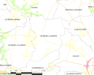
Le Mesnil-Garnier
- commune in Manche, France
- Country:
- Postal Code: 50450
- Coordinates: 48° 51' 55" N, 1° 18' 35" E
- GPS tracks (wikiloc): [Link]
- Area: 10.41 sq km
- Population: 232


Le Mesnil-Amand
- commune in Manche, France
- Country:
- Postal Code: 50450
- Coordinates: 48° 52' 53" N, 1° 21' 46" E
- GPS tracks (wikiloc): [Link]
- Area: 6.78 sq km
- Population: 174


Le Mesnil-Villeman
- commune in Manche, France
- Country:
- Postal Code: 50450
- Coordinates: 48° 51' 52" N, 1° 19' 39" E
- GPS tracks (wikiloc): [Link]
- Area: 10.8 sq km
- Population: 240
- Web site: [Link]

Ver
- commune in Manche, France
- Country:
- Postal Code: 50450
- Coordinates: 48° 53' 38" N, 1° 23' 34" E
- GPS tracks (wikiloc): [Link]
- Area: 13.27 sq km
- Population: 374


Saint-Denis-le-Gast
- commune in Manche, France
- Country:
- Postal Code: 50450
- Coordinates: 48° 56' 25" N, 1° 19' 46" E
- GPS tracks (wikiloc): [Link]
- Area: 16.73 sq km
- Population: 549

Montaigu-les-Bois
- commune in Manche, France
- Country:
- Postal Code: 50450
- Coordinates: 48° 53' 34" N, 1° 16' 46" E
- GPS tracks (wikiloc): [Link]
- Area: 6.67 sq km
- Population: 233


Lengronne
- commune in Manche, France
- Country:
- Postal Code: 50510
- Coordinates: 48° 56' 1" N, 1° 22' 57" E
- GPS tracks (wikiloc): [Link]
- Area: 12.07 sq km
- Population: 438


Sourdeval-les-Bois
- commune in Manche, France
- Country:
- Postal Code: 50450
- Coordinates: 48° 54' 37" N, 1° 15' 53" E
- GPS tracks (wikiloc): [Link]
- Area: 5.86 sq km
- Population: 202