Gindou (Gindou)

- commune in Lot, France
- Country:

- Postal Code: 46250
- Coordinates: 44° 37' 53" N, 1° 15' 0" E


- GPS tracks (wikiloc): [Link]
- Area: 15.65 sq km
- Population: 313
- Wikipedia en: wiki(en)
- Wikipedia: wiki(fr)
- Wikidata storage: Wikidata: Q1326501
- Wikipedia Commons Category: [Link]
- Freebase ID: [/m/03nwkxg]
- GeoNames ID: Alt: [6434782]
- SIREN number: [214601205]
- BnF ID: [15260861v]
- INSEE municipality code: 46120
Shares border with regions:

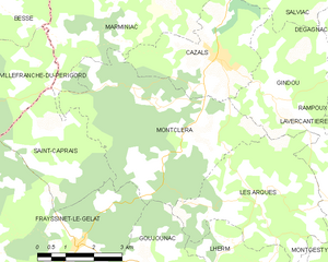
Montcléra
- commune in Lot, France
- Country:
- Postal Code: 46250
- Coordinates: 44° 37' 12" N, 1° 12' 37" E
- GPS tracks (wikiloc): [Link]
- Area: 20.91 sq km
- Population: 281


Rampoux
- commune in Lot, France
- Country:
- Postal Code: 46340
- Coordinates: 44° 38' 30" N, 1° 18' 36" E
- GPS tracks (wikiloc): [Link]
- Area: 5.83 sq km
- Population: 96

Thédirac
- commune in Lot, France
- Country:
- Postal Code: 46150
- Coordinates: 44° 36' 2" N, 1° 19' 3" E
- GPS tracks (wikiloc): [Link]
- Area: 16.51 sq km
- Population: 307


Lavercantière
- commune in Lot, France
- Country:
- Postal Code: 46340
- Coordinates: 44° 38' 15" N, 1° 19' 8" E
- GPS tracks (wikiloc): [Link]
- Area: 14.99 sq km
- Population: 237
- Web site: [Link]


Dégagnac
- commune in Lot, France
- Country:
- Postal Code: 46340
- Coordinates: 44° 39' 54" N, 1° 18' 57" E
- GPS tracks (wikiloc): [Link]
- Area: 37.9 sq km
- Population: 647


Cazals
- commune in Lot, France
- Country:
- Postal Code: 46250
- Coordinates: 44° 38' 36" N, 1° 13' 35" E
- GPS tracks (wikiloc): [Link]
- AboveSeaLevel: 177 м m
- Area: 10.57 sq km
- Population: 627
- Web site: [Link]


Les Arques
- commune in Lot, France
- Country:
- Postal Code: 46250
- Coordinates: 44° 36' 9" N, 1° 15' 3" E
- GPS tracks (wikiloc): [Link]
- Area: 15.05 sq km
- Population: 198


Salviac
- commune in Lot, France
- Country:
- Postal Code: 46340
- Coordinates: 44° 40' 52" N, 1° 15' 53" E
- GPS tracks (wikiloc): [Link]
- Area: 29.61 sq km
- Population: 1217
- Web site: [Link]


Montgesty
- commune in Lot, France
- Country:
- Postal Code: 46150
- Coordinates: 44° 34' 44" N, 1° 17' 49" E
- GPS tracks (wikiloc): [Link]
- Area: 11.88 sq km
- Population: 333