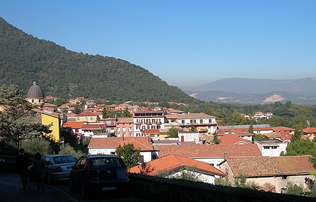
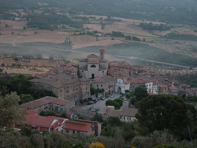
Giuliano di Roma (Giuliano di Roma)
.svg)
- Italian comune
 Hiking in Giuliano di Roma
Giuliano di Roma is a charming town located in the province of Frosinone in Italy's Lazio region. The area surrounding Giuliano di Roma offers a variety of hiking opportunities, characterized by picturesque landscapes, charming countryside, and historical sites.
Hiking Trails and Routes:
-
Nature and Scenic Trails:
- The region features various walking and hiking paths that range from easy strolls to more challenging hikes. Many of these trails offer stunning views of the Pontine Plain and the surrounding hills.
- The nearby Monti Ernici mountain range provides more challenging terrains and higher elevation hikes for those looking for an adventure.
-
Historical Paths:
- Some trails may lead you to historical sites, such as ancient ruins or old churches, allowing hikers to experience both nature and the rich cultural heritage of the area.
-
La Selva di Paliano:
- This nearby natural reserve offers marked trails through a diverse ecosystem. It's home to various flora and fauna, making it an excellent spot for both hiking and wildlife observation.
Tips for Hiking in Giuliano di Roma:
-
Seasonal Considerations:
- Spring and fall are ideal for hiking due to mild weather. Summers can be hot, so planning early morning hikes is recommended.
-
Local Guides:
- Consider hiring a local guide or joining a hiking group to enhance your experience. They can provide insights into the area’s natural and historical significance.
-
Equipment:
- Sturdy hiking shoes and appropriate clothing are essential. Carry enough water and snacks, especially for longer hikes.
-
Navigation:
- Some trails may not be well-marked, so bringing a map or using a GPS device can help navigate the terrain more effectively.
Wildlife and Nature:
The area around Giuliano di Roma features diverse ecosystems, making it a great destination for nature enthusiasts. Birdwatching and observing local wildlife can be quite rewarding.
Conclusion:
Hiking in and around Giuliano di Roma offers a wonderful blend of natural beauty and cultural history. Whether you are a seasoned hiker or a casual walker, there are plenty of opportunities to explore the stunning landscapes of this lesser-known part of Italy. Always remember to respect nature, follow local guidelines, and leave no trace while enjoying your hikes.
- Country:

- Postal Code: 03020
- Local Dialing Code: 0775
- Licence Plate Code: FR
- Coordinates: 41° 32' 0" N, 13° 17' 0" E


- GPS tracks (wikiloc): [Link]
- AboveSeaLevel: 363 м m
- Area: 33.54 sq km
- Population: 2417
- Web site: http://www.comune.giulianodiroma.fr.it
- Wikipedia en: wiki(en)
- Wikipedia: wiki(it)
- Wikidata storage: Wikidata: Q116937
- Wikipedia Commons Category: [Link]
- Freebase ID: [/m/0gmx3l]
- GeoNames ID: Alt: [6539982]
- VIAF ID: Alt: [244722054]
- OSM relation ID: [41366]
- ISTAT ID: 060041
- Italian cadastre code: E057
Shares border with regions:


Ceccano
- Italian comune
Hiking in Ceccano
Ceccano is a charming town in the province of Frosinone, Italy, nestled in the picturesque landscape of the Apennine Mountains. It offers several hiking opportunities that allow visitors to explore its natural beauty and rich history. Here are some key points about hiking in and around Ceccano:...
- Country:
- Postal Code: 03023
- Local Dialing Code: 0775
- Licence Plate Code: FR
- Coordinates: 41° 34' 0" N, 13° 20' 0" E
- GPS tracks (wikiloc): [Link]
- AboveSeaLevel: 200 м m
- Area: 61.06 sq km
- Population: 23380
- Web site: [Link]


Patrica
- Italian comune
Hiking in Patrica
Patrica, located in Italy, is known for its picturesque landscapes and hiking opportunities. Nestled within the beautiful region of Lazio, Patrica offers a mix of natural beauty, historical sites, and charming villages, making it a great spot for outdoor enthusiasts....
- Country:
- Postal Code: 03010
- Local Dialing Code: 0775
- Licence Plate Code: FR
- Coordinates: 41° 35' 0" N, 13° 15' 0" E
- GPS tracks (wikiloc): [Link]
- AboveSeaLevel: 450 м m
- Area: 27.31 sq km
- Population: 3161
- Web site: [Link]

Supino
- Italian comune
Hiking in Supino
Supino is a charming town in the province of Frosinone, Italy, located near the Amaseno valley. The surrounding region offers beautiful landscapes that are great for hiking enthusiasts. Here are some highlights and tips for hiking in and around Supino:...
- Country:
- Postal Code: 03019
- Local Dialing Code: 0775
- Licence Plate Code: FR
- Coordinates: 41° 37' 0" N, 13° 14' 0" E
- GPS tracks (wikiloc): [Link]
- AboveSeaLevel: 321 м m
- Area: 35.59 sq km
- Population: 4825
- Web site: [Link]
Villa Santo Stefano
- Italian comune
Hiking in Villa Santo Stefano
Villa Santo Stefano is a charming town located in the province of Frosinone, Italy, and offers a variety of hiking opportunities for nature enthusiasts and outdoor adventurers. Nestled in the scenic Monti Ernici mountain range, the area is characterized by its beautiful landscapes, lush forests, and rich biodiversity....
- Country:
- Postal Code: 03020
- Local Dialing Code: 0775
- Licence Plate Code: FR
- Coordinates: 41° 31' 0" N, 13° 19' 0" E
- GPS tracks (wikiloc): [Link]
- AboveSeaLevel: 205 м m
- Area: 20.1 sq km
- Population: 1703
- Web site: [Link]
Maenza
- Italian comune
Hiking in Maenza
Maenza is a charming town located in the province of Latina, Italy, and is surrounded by beautiful landscapes that offer a variety of hiking opportunities. The region is characterized by its rolling hills, lush vegetation, and stunning views of the surrounding countryside and coastal areas. Here are some key points to consider when hiking in and around Maenza:...
- Country:
- Postal Code: 04010
- Local Dialing Code: 0773
- Licence Plate Code: LT
- Coordinates: 41° 31' 0" N, 13° 11' 0" E
- GPS tracks (wikiloc): [Link]
- AboveSeaLevel: 358 м m
- Area: 42.13 sq km
- Population: 3118
- Web site: [Link]

Prossedi
- Italian comune
Hiking in Prossedi
Prossedi, a charming village located in the province of Latina in the Lazio region of Italy, offers a variety of hiking opportunities that allow you to explore its beautiful landscapes, rich history, and local culture. Here are some highlights of hiking in Prossedi:...
- Country:
- Postal Code: 04010
- Local Dialing Code: 0773
- Licence Plate Code: LT
- Coordinates: 41° 31' 0" N, 13° 16' 0" E
- GPS tracks (wikiloc): [Link]
- AboveSeaLevel: 206 м m
- Area: 35.37 sq km
- Population: 1203
- Web site: [Link]