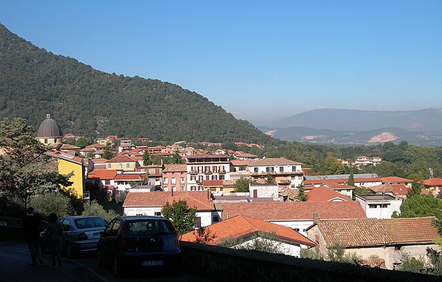
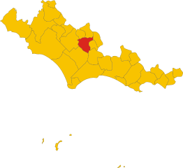
Maenza (Maenza)
.svg)
- Italian comune
 Hiking in Maenza
Maenza is a charming town located in the province of Latina, Italy, and is surrounded by beautiful landscapes that offer a variety of hiking opportunities. The region is characterized by its rolling hills, lush vegetation, and stunning views of the surrounding countryside and coastal areas. Here are some key points to consider when hiking in and around Maenza:
Hiking Trails
-
Local Trails: There are several local trails around Maenza that cater to different skill levels. These paths often take you through scenic olive groves, vineyards, and forests.
-
Monte Lungo: A popular hiking destination near Maenza, Monte Lungo offers trails with varying difficulties, providing panoramic views at the summit. It's a great spot for both experienced hikers and families.
-
Cicero's Path: This historical path originates from the Roman times and offers a glimpse into the area's ancient history as well as being a great way to connect with nature.
Nature and Scenery
- Flora and Fauna: The area is rich in biodiversity, and hikers might spot various species of plants and animals unique to the Mediterranean region.
- Panoramic Views: Many trails provide breathtaking views of the nearby hills, valleys, and even the Tyrrhenian Sea on clear days.
Tips for Hiking in Maenza
- Prepare for Varying Weather: The climate can vary, so check weather conditions and prepare accordingly. Mornings can be cool, while afternoons may get warm.
- Footwear and Gear: Comfortable, sturdy hiking boots are a must, along with weather-appropriate clothing and plenty of water.
- Local Regulations: Be aware of any local regulations regarding trail usage, and respect the wildlife and natural surroundings.
- Guided Tours: If you're unfamiliar with the area, consider joining a guided tour for a more informative experience.
Safety
- Always let someone know your hiking plans, especially if you're going off well-trodden paths.
- Carry a map or GPS device, as some trails can be less marked.
- Stay hydrated and pack snacks for energy.
Conclusion
Hiking around Maenza provides a great opportunity to explore the natural beauty and rich history of the region. With its diverse trails and stunning landscapes, it's an excellent destination for both casual walkers and serious hikers. Enjoy your adventure!
- Country:

- Postal Code: 04010
- Local Dialing Code: 0773
- Licence Plate Code: LT
- Coordinates: 41° 31' 0" N, 13° 11' 0" E


- GPS tracks (wikiloc): [Link]
- AboveSeaLevel: 358 м m
- Area: 42.13 sq km
- Population: 3118
- Web site: http://www.comunedimaenza.it
- Wikipedia en: wiki(en)
- Wikipedia: wiki(it)
- Wikidata storage: Wikidata: Q128103
- Wikipedia Commons Category: [Link]
- Freebase ID: [/m/0gm8tx]
- GeoNames ID: Alt: [6536971]
- VIAF ID: Alt: [240540660]
- OSM relation ID: [41346]
- TGN ID: [1045176]
- ISTAT ID: 059013
- Italian cadastre code: E798
Shares border with regions:
Giuliano di Roma
- Italian comune
Hiking in Giuliano di Roma
Giuliano di Roma is a charming town located in the province of Frosinone in Italy's Lazio region. The area surrounding Giuliano di Roma offers a variety of hiking opportunities, characterized by picturesque landscapes, charming countryside, and historical sites....
- Country:
- Postal Code: 03020
- Local Dialing Code: 0775
- Licence Plate Code: FR
- Coordinates: 41° 32' 0" N, 13° 17' 0" E
- GPS tracks (wikiloc): [Link]
- AboveSeaLevel: 363 м m
- Area: 33.54 sq km
- Population: 2417
- Web site: [Link]

Supino
- Italian comune
Hiking in Supino
Supino is a charming town in the province of Frosinone, Italy, located near the Amaseno valley. The surrounding region offers beautiful landscapes that are great for hiking enthusiasts. Here are some highlights and tips for hiking in and around Supino:...
- Country:
- Postal Code: 03019
- Local Dialing Code: 0775
- Licence Plate Code: FR
- Coordinates: 41° 37' 0" N, 13° 14' 0" E
- GPS tracks (wikiloc): [Link]
- AboveSeaLevel: 321 м m
- Area: 35.59 sq km
- Population: 4825
- Web site: [Link]

Priverno
- Italian comune
Hiking in Priverno
Priverno, a charming town located in the Province of Latina in Italy's Lazio region, offers various hiking opportunities that cater to outdoor enthusiasts of all levels. The surrounding landscapes are characterized by rolling hills, ancient ruins, and the picturesque scenery of the nearby Lepini Mountains. Here are some key points about hiking in the Priverno area:...
- Country:
- Postal Code: 04015
- Local Dialing Code: 0773
- Licence Plate Code: LT
- Coordinates: 41° 28' 0" N, 13° 11' 0" E
- GPS tracks (wikiloc): [Link]
- AboveSeaLevel: 151 м m
- Area: 56.98 sq km
- Population: 14365
- Web site: [Link]

Prossedi
- Italian comune
Hiking in Prossedi
Prossedi, a charming village located in the province of Latina in the Lazio region of Italy, offers a variety of hiking opportunities that allow you to explore its beautiful landscapes, rich history, and local culture. Here are some highlights of hiking in Prossedi:...
- Country:
- Postal Code: 04010
- Local Dialing Code: 0773
- Licence Plate Code: LT
- Coordinates: 41° 31' 0" N, 13° 16' 0" E
- GPS tracks (wikiloc): [Link]
- AboveSeaLevel: 206 м m
- Area: 35.37 sq km
- Population: 1203
- Web site: [Link]
Roccagorga
- Italian comune
Hiking in Roccagorga
Roccagorga, located in the province of Latina in Italy, is a charming village nestled in the picturesque landscape of the Aurunci Mountains. The area offers beautiful hiking opportunities due to its diverse terrain, rich biodiversity, and stunning views of the surrounding region....
- Country:
- Postal Code: 04010
- Local Dialing Code: 0773
- Licence Plate Code: LT
- Coordinates: 41° 32' 0" N, 13° 9' 0" E
- GPS tracks (wikiloc): [Link]
- AboveSeaLevel: 287 м m
- Area: 24.49 sq km
- Population: 4478
- Web site: [Link]


Carpineto Romano
- Italian comune
Hiking in Carpineto Romano
Carpineto Romano, located in the Lazio region of Italy, is a wonderful destination for hiking enthusiasts. Nestled in the Monti Lepini mountain range, this charming town is surrounded by stunning natural landscapes, making it an ideal spot for various outdoor activities....
- Country:
- Postal Code: 00032
- Local Dialing Code: 06
- Licence Plate Code: ROMA
- Coordinates: 41° 36' 0" N, 13° 5' 0" E
- GPS tracks (wikiloc): [Link]
- AboveSeaLevel: 550 м m
- Area: 86.29 sq km
- Population: 4425
- Web site: [Link]