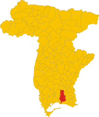
Gonars (Gonars)
.svg)
- Italian comune
 Hiking in Gonars
Gonars, a small town in northeastern Italy, is located in the region of Friuli Venezia Giulia. While it may not be a primary destination for hikers compared to more prominent national parks or mountainous areas in Italy, it offers beautiful landscapes and trails for outdoor enthusiasts, particularly for those interested in exploring the countryside and enjoying scenic walks.
Hiking in Gonars:
-
Trails and Terrain:
- The area around Gonars features gentle rolling hills, agricultural fields, and lush greenery. The terrain is suitable for a variety of skill levels.
- There might not be marked trails in the immediate vicinity, but you can explore rural paths and unpaved roads. Always check local maps or apps for any existing hiking routes.
-
Scenic Views:
- The rural landscape provides beautiful views of the surrounding countryside, especially fields of sunflowers and vineyards. The nearby Alps can also be seen from higher vantage points.
-
Weather:
- The weather can vary significantly between seasons. Summers are typically warm and great for hiking, while winters can be cold, so be prepared accordingly. Spring and fall offer mild temperatures ideal for longer hikes.
-
Local Attractions:
- Combine your hiking with visits to local sites, such as historic churches or farms that may offer local produce, enhancing your experience.
- Take advantage of local culinary attractions, as Friuli Venezia Giulia is known for its unique cuisine. Enjoy a picnic with local snacks after a day’s hike.
-
Nearby Hiking Spots:
- Consider exploring nearby natural reserves or parks, such as the Foiba di Villanova or the larger Julian Alps, which offer more expansive and challenging hiking options.
Tips for Hiking in Gonars:
- Safety: Always inform someone about your hiking plans and expected return time, especially if exploring remote paths.
- Footwear: Wear appropriate hiking shoes or boots, as rural paths can be uneven and muddy.
- Supplies: Carry water, snacks, a map or GPS, and a first-aid kit. The local shops might not always have extensive offerings.
- Respect Nature: Follow Leave No Trace principles to preserve the natural beauty of the area.
Gonars is perfect for those who enjoy quieter hikes away from the crowds. With some planning, you can create a lovely hiking experience that combines nature, culture, and serenity.
- Country:

- Postal Code: 33050
- Local Dialing Code: 0432
- Licence Plate Code: UD
- Coordinates: 45° 54' 0" N, 13° 14' 0" E


- GPS tracks (wikiloc): [Link]
- AboveSeaLevel: 21 м m
- Area: 19.82 sq km
- Population: 4718
- Web site: http://www.comune.gonars.ud.it
- Wikipedia en: wiki(en)
- Wikipedia: wiki(it)
- Wikidata storage: Wikidata: Q53266
- Wikipedia Commons Category: [Link]
- Freebase ID: [/m/0536jv]
- GeoNames ID: Alt: [6536312]
- VIAF ID: Alt: [129214698]
- OSM relation ID: [79250]
- WOEID: [716263]
- UN/LOCODE: [ITGS5]
- ISTAT ID: 030044
- Italian cadastre code: E083
Shares border with regions:
Bagnaria Arsa
- Italian comune
Hiking in Bagnaria Arsa
Bagnaria Arsa, located in the Friuli Venezia Giulia region of northeastern Italy, offers a variety of hiking opportunities that showcase the natural beauty of the surrounding landscapes. This area is characterized by its rolling hills, scenic views, and rich cultural heritage....
- Country:
- Postal Code: 33050
- Local Dialing Code: 0432
- Licence Plate Code: UD
- Coordinates: 45° 53' 0" N, 13° 17' 0" E
- GPS tracks (wikiloc): [Link]
- AboveSeaLevel: 20 м m
- Area: 19.23 sq km
- Population: 3483
- Web site: [Link]
Bicinicco
- Italian comune
Hiking in Bicinicco
Bicinicco is a small commune located in the Friuli Venezia Giulia region of Italy. While it may not be as well-known as some of the larger tourist destinations, it offers some beautiful landscapes and opportunities for hiking in the surrounding areas. Here are some key points to consider if you're planning to hike in and around Bicinicco:...
- Country:
- Postal Code: 33050
- Local Dialing Code: 0432
- Licence Plate Code: UD
- Coordinates: 45° 56' 0" N, 13° 15' 0" E
- GPS tracks (wikiloc): [Link]
- AboveSeaLevel: 37 м m
- Area: 16.01 sq km
- Population: 1867
- Web site: [Link]
Castions di Strada
- Italian comune
Hiking in Castions di Strada
Castions di Strada is a small village located in the Friuli Venezia Giulia region of northeastern Italy. While it may not be as popular as other hiking destinations in the region, it is surrounded by beautiful landscapes and offers some charming hiking opportunities through the surrounding countryside....
- Country:
- Postal Code: 33050
- Local Dialing Code: 0432
- Licence Plate Code: UD
- Coordinates: 45° 54' 0" N, 13° 11' 0" E
- GPS tracks (wikiloc): [Link]
- AboveSeaLevel: 23 м m
- Area: 32.84 sq km
- Population: 3767
- Web site: [Link]
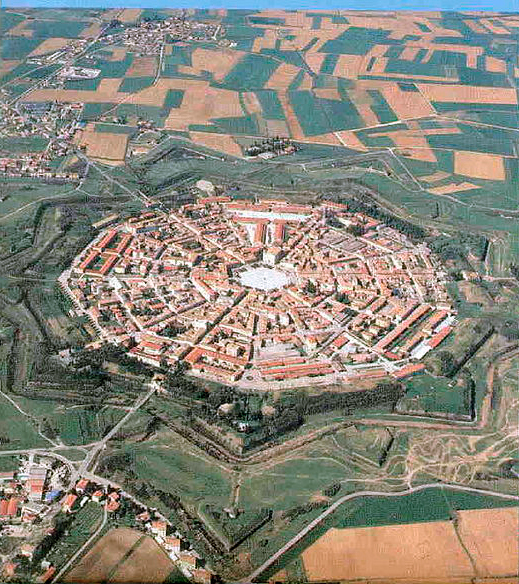

Palmanova
- Italian town and comune in northeastern Italy, in the Province Udine
Hiking in Palmanova
Palmanova, located in the Friuli Venezia Giulia region of Italy, is a unique destination known for its star-shaped fortress design dating back to the 16th century. While it is primarily recognized for its historical significance and architecture, the surrounding area offers several opportunities for hiking and exploring nature....
- Country:
- Postal Code: 33057
- Local Dialing Code: 0432
- Licence Plate Code: UD
- Coordinates: 45° 54' 0" N, 13° 19' 0" E
- GPS tracks (wikiloc): [Link]
- AboveSeaLevel: 27 м m
- Area: 13.3 sq km
- Population: 5419
- Web site: [Link]
Porpetto
- Italian comune
Hiking in Porpetto
Hiking in Porpetto, located in the Friuli Venezia Giulia region of Italy, offers a delightful blend of scenic landscapes, cultural landmarks, and nature experiences. While Porpetto itself is a small town, it is surrounded by beautiful areas that are great for hiking....
- Country:
- Postal Code: 33050
- Local Dialing Code: 0431
- Licence Plate Code: UD
- Coordinates: 45° 51' 0" N, 13° 13' 0" E
- GPS tracks (wikiloc): [Link]
- AboveSeaLevel: 10 м m
- Area: 18.05 sq km
- Population: 2577
- Web site: [Link]


Santa Maria la Longa
- Italian comune
Hiking in Santa Maria la Longa
Santa Maria la Longa is a charming village located in the northeastern part of Italy, in the region of Friuli Venezia Giulia. While it's a small village, its proximity to natural landscapes and the surrounding areas provides some lovely opportunities for hiking and outdoor activities....
- Country:
- Postal Code: 33050
- Local Dialing Code: 0432
- Licence Plate Code: UD
- Coordinates: 45° 56' 1" N, 13° 17' 24" E
- GPS tracks (wikiloc): [Link]
- AboveSeaLevel: 38 м m
- Area: 19.6 sq km
- Population: 2313
- Web site: [Link]

Torviscosa
- Italian comune
Hiking in Torviscosa
Torviscosa is a small town located in the Friuli Venezia Giulia region of Italy. While it is not a major hiking destination compared to some other Italian regions, there are still opportunities for outdoor enthusiasts to explore the natural beauty of the area and nearby landscapes....
- Country:
- Postal Code: 33050
- Local Dialing Code: 0431
- Licence Plate Code: UD
- Coordinates: 45° 49' 0" N, 13° 17' 0" E
- GPS tracks (wikiloc): [Link]
- AboveSeaLevel: 3 м m
- Area: 48.62 sq km
- Population: 2829
- Web site: [Link]