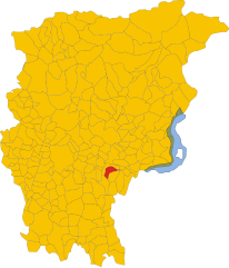
Gorlago (Gorlago)
.svg)
- Italian comune
 Hiking in Gorlago
Gorlago is a picturesque town located in the Lombardy region of northern Italy, near the city of Bergamo. The area around Gorlago offers a variety of hiking opportunities that showcase the stunning landscapes of the Italian countryside, including rolling hills, forests, and panoramic views of the surrounding mountains.
Here are some tips and information about hiking in Gorlago:
Popular Hiking Trails
-
Sentiero dei Dossi: A scenic trail that provides beautiful views of the surrounding valleys and hills. It's a moderate hike suitable for hikers of various skill levels. Be sure to bring your camera!
-
Monte Canto: This trail leads to the summit of Monte Canto, where you can enjoy breathtaking views of the Bergamo Alps and the Po Valley. The hike can be challenging but is rewarding for those who reach the top.
-
Parco dei Colli di Bergamo: Just a short distance from Gorlago, this park offers numerous hiking trails that wind through its diverse ecosystems, including forests and meadows. Trails vary in difficulty, catering to both casual walkers and experienced hikers.
Tips for Hiking in Gorlago
- Map and Compass: Always carry a physical map or a GPS device, as cell phone service may be spotty in rural areas.
- Proper Footwear: Wear sturdy hiking boots with good grip to navigate various terrain types safely.
- Physical Preparedness: Make sure you are in good physical condition, especially for more challenging hikes.
- Weather Awareness: The weather can change quickly in the mountains. Check forecasts and be prepared for sudden rain or temperature drops.
- Stay Hydrated: Bring plenty of water, especially during warm weather, and pack some snacks to keep your energy up.
- Respect Nature: Follow Leave No Trace principles to minimize your impact on the environment.
Local Attractions
When you're not hiking, consider exploring Gorlago itself, which has charming streets, local shops, and dining options. Nearby Bergamo, with its rich history and beautiful architecture, is also worth visiting for a break from hiking.
Conclusion
Gorlago and its surrounding areas offer a variety of hiking experiences for all levels of hikers. Whether you are looking for a peaceful walk in nature or a challenging climb with expansive views, Gorlago has something to offer. Make sure to plan accordingly and enjoy your time in this beautiful part of Italy!
- Country:

- Postal Code: 24060
- Local Dialing Code: 035
- Licence Plate Code: BG
- Coordinates: 45° 40' 0" N, 9° 49' 0" E


- GPS tracks (wikiloc): [Link]
- AboveSeaLevel: 233 м m
- Area: 5.7 sq km
- Population: 5188
- Web site: http://www.comune.gorlago.bg.it
- Wikipedia en: wiki(en)
- Wikipedia: wiki(it)
- Wikidata storage: Wikidata: Q101142
- Wikipedia Commons Gallery: [Link]
- Wikipedia Commons Category: [Link]
- Freebase ID: [/m/0gjblr]
- GeoNames ID: Alt: [6542956]
- VIAF ID: Alt: [241198935]
- OSM relation ID: [45644]
- UN/LOCODE: [ITIOR]
- ISTAT ID: 016114
- Italian cadastre code: E100
Shares border with regions:

Carobbio degli Angeli
- Italian comune
Hiking in Carobbio degli Angeli
Carobbio degli Angeli is a quaint municipality located in the province of Bergamo, in the Lombardy region of Italy. While it may not be as well-known for hiking as other areas in Italy, it offers some beautiful natural surroundings and trails that can appeal to outdoor enthusiasts....
- Country:
- Postal Code: 24060
- Local Dialing Code: 035
- Licence Plate Code: BG
- Coordinates: 45° 40' 0" N, 9° 50' 0" E
- GPS tracks (wikiloc): [Link]
- AboveSeaLevel: 232 м m
- Area: 6.82 sq km
- Population: 4700
- Web site: [Link]


Costa di Mezzate
- Italian comune
Hiking in Costa di Mezzate
Costa di Mezzate is a charming location in Italy, located in the province of Bergamo in Lombardy. It's a great spot for hiking, particularly for those who enjoy scenic trails and beautiful landscapes. Here are some details about hiking in Costa di Mezzate:...
- Country:
- Postal Code: 24060
- Local Dialing Code: 035
- Licence Plate Code: BG
- Coordinates: 45° 40' 0" N, 9° 48' 0" E
- GPS tracks (wikiloc): [Link]
- AboveSeaLevel: 218 м m
- Area: 5.22 sq km
- Population: 3374
- Web site: [Link]


Montello, Lombardy
- Italian comune
Hiking in Montello, Lombardy
Montello is a beautiful area in Lombardy, Italy, known for its picturesque landscapes, rich natural beauty, and various outdoor activities, including hiking. Here are some key points about hiking in Montello:...
- Country:
- Postal Code: 24060
- Local Dialing Code: 035
- Licence Plate Code: BG
- Coordinates: 45° 40' 0" N, 9° 48' 0" E
- GPS tracks (wikiloc): [Link]
- AboveSeaLevel: 229 м m
- Area: 1.82 sq km
- Population: 3263
- Web site: [Link]


San Paolo d'Argon
- Italian comune
Hiking in San Paolo d'Argon
San Paolo d'Argon, located in the province of Bergamo in northern Italy, offers a variety of hiking opportunities amidst beautiful landscapes. The region is characterized by its rolling hills, vineyards, and scenic views of the surrounding valleys and mountains, including the nearby Orobian Alps....
- Country:
- Postal Code: 24060
- Local Dialing Code: 035
- Licence Plate Code: BG
- Coordinates: 45° 41' 21" N, 9° 48' 11" E
- GPS tracks (wikiloc): [Link]
- AboveSeaLevel: 255 м m
- Area: 5.25 sq km
- Population: 5725
- Web site: [Link]


Trescore Balneario
- Italian comune
Hiking in Trescore Balneario
Trescore Balneario, located in the province of Bergamo in northern Italy, is a charming town known for its thermal baths and scenic landscapes. While it's not as widely recognized for hiking as some other areas in the Italian Alps, it can serve as a great base for exploring nearby trails and natural attractions....
- Country:
- Postal Code: 24069
- Local Dialing Code: 035
- Licence Plate Code: BG
- Coordinates: 45° 42' 0" N, 9° 51' 0" E
- GPS tracks (wikiloc): [Link]
- AboveSeaLevel: 271 м m
- Area: 13.51 sq km
- Population: 9814
- Web site: [Link]


Bolgare
- Italian comune
Hiking in Bolgare
Bolgare is a small town in the province of Bergamo, Lombardy, Italy. Nestled in a beautiful region that offers access to the stunning landscapes of the Italian Alps, Bolgare is a great starting point for various hiking adventures....
- Country:
- Postal Code: 24060
- Local Dialing Code: 035
- Licence Plate Code: BG
- Coordinates: 45° 38' 3" N, 9° 49' 1" E
- GPS tracks (wikiloc): [Link]
- AboveSeaLevel: 199 м m
- Area: 8.59 sq km
- Population: 6183
- Web site: [Link]