Gourin (Gourin)

- commune in Morbihan, France
- Country:

- Postal Code: 56110
- Coordinates: 48° 8' 22" N, 3° 36' 27" E


- GPS tracks (wikiloc): [Link]
- Area: 74.72 sq km
- Population: 3972
- Web site: http://www.gourin.fr
- Wikipedia en: wiki(en)
- Wikipedia: wiki(fr)
- Wikidata storage: Wikidata: Q71216
- Wikipedia Commons Category: [Link]
- Freebase ID: [/m/03c4bv4]
- GeoNames ID: Alt: [3015522]
- SIREN number: [215600669]
- BnF ID: [15265316v]
- VIAF ID: Alt: [168355637]
- Library of Congress authority ID: Alt: [n93118208]
- WOEID: [593259]
- INSEE municipality code: 56066
Shares border with regions:


Le Saint
- commune in Morbihan, France
- Country:
- Postal Code: 56110
- Coordinates: 48° 5' 22" N, 3° 33' 44" E
- GPS tracks (wikiloc): [Link]
- Area: 31.03 sq km
- Population: 599

Roudouallec
- commune in Morbihan, France
- Country:
- Postal Code: 56110
- Coordinates: 48° 7' 36" N, 3° 43' 1" E
- GPS tracks (wikiloc): [Link]
- Area: 24.82 sq km
- Population: 728

Spézet
- commune in Finistère, France
- Country:
- Postal Code: 29540
- Coordinates: 48° 11' 33" N, 3° 43' 0" E
- GPS tracks (wikiloc): [Link]
- Area: 60.67 sq km
- Population: 1821
- Web site: [Link]


Saint-Hernin
- commune in Finistère, France
- Country:
- Postal Code: 29270
- Coordinates: 48° 13' 5" N, 3° 38' 5" E
- GPS tracks (wikiloc): [Link]
- AboveSeaLevel: 120 м m
- Area: 29.29 sq km
- Population: 760
- Web site: [Link]

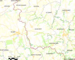
Guiscriff
- commune in Morbihan, France
- Country:
- Postal Code: 56560
- Coordinates: 48° 3' 0" N, 3° 38' 43" E
- GPS tracks (wikiloc): [Link]
- Area: 85.46 sq km
- Population: 2155


Langonnet
- commune in Morbihan, France
- Country:
- Postal Code: 56630
- Coordinates: 48° 6' 20" N, 3° 29' 36" E
- GPS tracks (wikiloc): [Link]
- Area: 85.4 sq km
- Population: 1858
- Web site: [Link]


Tréogan
- commune in Côtes-d'Armor, France
- Country:
- Postal Code: 22340
- Coordinates: 48° 11' 21" N, 3° 31' 12" E
- GPS tracks (wikiloc): [Link]
- Area: 7.1 sq km
- Population: 100