Gours (Gours)

- commune in Gironde, France
- Country:

- Postal Code: 33660
- Coordinates: 44° 59' 37" N, 0° 1' 21" E


- GPS tracks (wikiloc): [Link]
- Area: 7.89 sq km
- Population: 538
- Wikipedia en: wiki(en)
- Wikipedia: wiki(fr)
- Wikidata storage: Wikidata: Q286347
- Wikipedia Commons Category: [Link]
- Freebase ID: [/m/03nrzn5]
- GeoNames ID: Alt: [6612479]
- SIREN number: [213301914]
- BnF ID: [15256243h]
- INSEE municipality code: 33191
Shares border with regions:


Saint-Seurin-sur-l'Isle
- commune in Gironde, France
- Country:
- Postal Code: 33660
- Coordinates: 45° 0' 51" N, 0° 0' 6" E
- GPS tracks (wikiloc): [Link]
- AboveSeaLevel: 22 м m
- Area: 8.83 sq km
- Population: 3163

Minzac
- commune in Dordogne, France
- Country:
- Postal Code: 24610
- Coordinates: 44° 58' 20" N, 0° 2' 14" E
- GPS tracks (wikiloc): [Link]
- Area: 15.91 sq km
- Population: 456
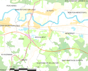
Moulin-Neuf
- commune in Dordogne, France
- Country:
- Postal Code: 24700
- Coordinates: 45° 0' 39" N, 0° 3' 3" E
- GPS tracks (wikiloc): [Link]
- Area: 8.62 sq km
- Population: 908


Saint-Antoine-sur-l'Isle
- commune in Gironde, France
- Country:
- Postal Code: 33660
- Coordinates: 45° 1' 37" N, 0° 2' 17" E
- GPS tracks (wikiloc): [Link]
- Area: 10.4 sq km
- Population: 578
- Web site: [Link]

Puynormand
- commune in Gironde, France
- Country:
- Postal Code: 33660
- Coordinates: 44° 58' 57" N, 0° 0' 2" E
- GPS tracks (wikiloc): [Link]
- AboveSeaLevel: 92 м m
- Area: 7.64 sq km
- Population: 307
- Web site: [Link]