canton of Lussac (canton de Lussac)
- canton in France
- Country:

- Capital: Lussac
- Coordinates: 44° 57' 12" N, 0° 4' 7" E


- GPS tracks (wikiloc): [Link]
- Wikidata storage: Wikidata: Q26850
- INSEE canton code: [3331]
Includes regions:

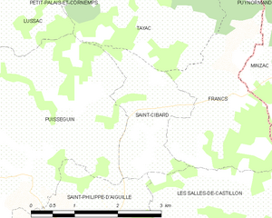
Saint-Cibard
- commune in Gironde, France
- Country:
- Postal Code: 33570
- Coordinates: 44° 56' 24" N, 0° 1' 24" E
- GPS tracks (wikiloc): [Link]
- Area: 3.54 sq km
- Population: 181
- Web site: [Link]

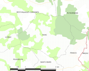
Tayac
- commune in Gironde, France
- Country:
- Postal Code: 33570
- Coordinates: 44° 57' 9" N, 0° 0' 36" E
- GPS tracks (wikiloc): [Link]
- AboveSeaLevel: 90 м m
- Area: 7.22 sq km
- Population: 132

Francs
- commune in Gironde, France
- Country:
- Postal Code: 33570
- Coordinates: 44° 56' 44" N, 0° 0' 22" E
- GPS tracks (wikiloc): [Link]
- AboveSeaLevel: 98 м m
- Area: 6.59 sq km
- Population: 195
- Web site: [Link]

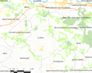
Lussac
- commune in Gironde, France
- Country:
- Postal Code: 33570
- Coordinates: 44° 57' 0" N, 0° 5' 46" E
- GPS tracks (wikiloc): [Link]
- Area: 23.43 sq km
- Population: 1284
- Web site: [Link]

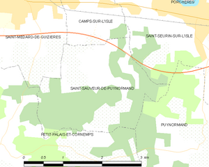
Saint-Sauveur-de-Puynormand
- commune in Gironde, France
- Country:
- Postal Code: 33660
- Coordinates: 44° 59' 57" N, 0° 2' 8" E
- GPS tracks (wikiloc): [Link]
- Area: 5.57 sq km
- Population: 368
- Web site: [Link]

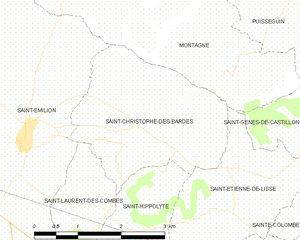
Saint-Christophe-des-Bardes
- commune in Gironde, France
- Country:
- Postal Code: 33330
- Coordinates: 44° 53' 47" N, 0° 7' 22" E
- GPS tracks (wikiloc): [Link]
- Area: 7.69 sq km
- Population: 447
- Web site: [Link]


Montagne
- commune in Gironde, France
- Country:
- Postal Code: 33570
- Coordinates: 44° 55' 49" N, 0° 7' 46" E
- GPS tracks (wikiloc): [Link]
- Area: 26.66 sq km
- Population: 1554
- Web site: [Link]


Gours
- commune in Gironde, France
- Country:
- Postal Code: 33660
- Coordinates: 44° 59' 37" N, 0° 1' 21" E
- GPS tracks (wikiloc): [Link]
- Area: 7.89 sq km
- Population: 538


Petit-Palais-et-Cornemps
- commune in Gironde, France
- Country:
- Postal Code: 33570
- Coordinates: 44° 58' 52" N, 0° 3' 48" E
- GPS tracks (wikiloc): [Link]
- Area: 14.32 sq km
- Population: 745

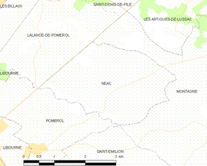
Néac
- commune in Gironde, France
- Country:
- Postal Code: 33500
- Coordinates: 44° 56' 26" N, 0° 10' 45" E
- GPS tracks (wikiloc): [Link]
- Area: 6.88 sq km
- Population: 405


Les Artigues-de-Lussac
- commune in Gironde, France
- Country:
- Postal Code: 33570
- Coordinates: 44° 58' 18" N, 0° 8' 22" E
- GPS tracks (wikiloc): [Link]
- Area: 10.16 sq km
- Population: 1095

Puynormand
- commune in Gironde, France
- Country:
- Postal Code: 33660
- Coordinates: 44° 58' 57" N, 0° 0' 2" E
- GPS tracks (wikiloc): [Link]
- AboveSeaLevel: 92 м m
- Area: 7.64 sq km
- Population: 307
- Web site: [Link]


Puisseguin
- commune in Gironde, France
- Country:
- Postal Code: 33570
- Coordinates: 44° 55' 25" N, 0° 4' 23" E
- GPS tracks (wikiloc): [Link]
- Area: 17.25 sq km
- Population: 869
- Web site: [Link]