Puynormand (Puynormand)

- commune in Gironde, France
- Country:

- Postal Code: 33660
- Coordinates: 44° 58' 57" N, 0° 0' 2" E


- GPS tracks (wikiloc): [Link]
- AboveSeaLevel: 92 м m
- Area: 7.64 sq km
- Population: 307
- Web site: http://www.puynormand.fr
- Wikipedia en: wiki(en)
- Wikipedia: wiki(fr)
- Wikidata storage: Wikidata: Q720248
- Wikipedia Commons Category: [Link]
- Freebase ID: [/m/03ns0jq]
- GeoNames ID: Alt: [6454016]
- SIREN number: [213303472]
- BnF ID: [15256397q]
- INSEE municipality code: 33347
Shares border with regions:

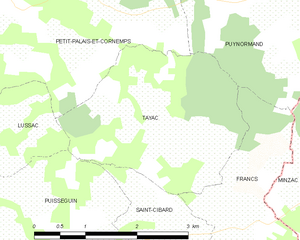
Tayac
- commune in Gironde, France
- Country:
- Postal Code: 33570
- Coordinates: 44° 57' 9" N, 0° 0' 36" E
- GPS tracks (wikiloc): [Link]
- AboveSeaLevel: 90 м m
- Area: 7.22 sq km
- Population: 132


Saint-Seurin-sur-l'Isle
- commune in Gironde, France
- Country:
- Postal Code: 33660
- Coordinates: 45° 0' 51" N, 0° 0' 6" E
- GPS tracks (wikiloc): [Link]
- AboveSeaLevel: 22 м m
- Area: 8.83 sq km
- Population: 3163

Francs
- commune in Gironde, France
- Country:
- Postal Code: 33570
- Coordinates: 44° 56' 44" N, 0° 0' 22" E
- GPS tracks (wikiloc): [Link]
- AboveSeaLevel: 98 м m
- Area: 6.59 sq km
- Population: 195
- Web site: [Link]

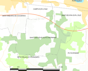
Saint-Sauveur-de-Puynormand
- commune in Gironde, France
- Country:
- Postal Code: 33660
- Coordinates: 44° 59' 57" N, 0° 2' 8" E
- GPS tracks (wikiloc): [Link]
- Area: 5.57 sq km
- Population: 368
- Web site: [Link]


Gours
- commune in Gironde, France
- Country:
- Postal Code: 33660
- Coordinates: 44° 59' 37" N, 0° 1' 21" E
- GPS tracks (wikiloc): [Link]
- Area: 7.89 sq km
- Population: 538


Petit-Palais-et-Cornemps
- commune in Gironde, France
- Country:
- Postal Code: 33570
- Coordinates: 44° 58' 52" N, 0° 3' 48" E
- GPS tracks (wikiloc): [Link]
- Area: 14.32 sq km
- Population: 745

Minzac
- commune in Dordogne, France
- Country:
- Postal Code: 24610
- Coordinates: 44° 58' 20" N, 0° 2' 14" E
- GPS tracks (wikiloc): [Link]
- Area: 15.91 sq km
- Population: 456