Graffignana (Graffignana)
- Italian comune
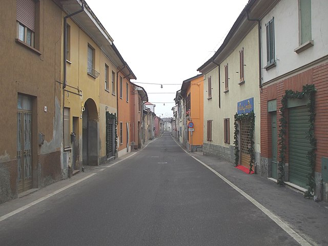
Graffignana is a small town located in the Lombardy region of northern Italy. While it might not be as well-known for hiking as some other areas in Italy, there are still opportunities for outdoor enthusiasts to enjoy nature and engage in hiking activities in and around the town.
General Considerations for Hiking in Graffignana:
-
Surrounding Nature: The area surrounding Graffignana includes farmland, rural landscapes, and some hills that can offer pleasant walking paths. The terrain is generally not mountainous, but you can find scenic routes perfect for leisurely hikes.
-
Local Parks and Trails: Look for local parks and marked trails in the vicinity. Check for any municipal or regional parks that may provide dedicated walking paths or nature trails.
-
Wildlife and Flora: Hiking in this area can give you the opportunity to observe local wildlife and the variety of flora typical of the Lombardy region. Always be respectful of nature, avoiding picking plants or disturbing local animals.
-
Seasonal Considerations: If you're hiking during the warmer months, ensure you bring plenty of water, wear sunscreen, and be prepared for the heat. In the cooler months, be aware of the weather conditions and dress in layers.
-
Nearby Attractions: Consider day trips to nearby more prominent hiking areas, such as the Adda River Park or the hills of the Oltrepò Pavese region. These areas feature marked trails and varying levels of difficulty that cater to all hikers.
-
Safety: Always inform someone about your plans if you’re hiking alone. Be sure to have a map or GPS, and it's wise to understand the basic trail etiquette and safety measures.
Recommended Hiking Tips:
-
Footwear: Wear sturdy hiking shoes or boots to ensure comfort and protect your feet during walks on rougher terrains.
-
Pack Essentials: Bring a small backpack with water, snacks, a first-aid kit, and any other necessary supplies you might need.
-
Stay Informed: Check local guidelines, and if possible, connect with local hiking groups or forums for the latest information on trails and conditions.
If you're planning a visit to Graffignana, checking out local resources or asking locals can provide you with additional insights into the best hiking options available. Enjoy your hike!
- Country:

- Postal Code: 26813
- Local Dialing Code: 0371
- Licence Plate Code: LO
- Coordinates: 45° 12' 27" N, 9° 27' 19" E


- GPS tracks (wikiloc): [Link]
- AboveSeaLevel: 67 м m
- Area: 10.92 sq km
- Population: 2612
- Web site: http://www.comunedigraffignana.it/
- Wikipedia en: wiki(en)
- Wikipedia: wiki(it)
- Wikidata storage: Wikidata: Q42954
- Wikipedia Commons Category: [Link]
- Freebase ID: [/m/0gr5n5]
- GeoNames ID: Alt: [6543350]
- OSM relation ID: [44439]
- UN/LOCODE: [ITFFI]
- ISTAT ID: 098028
- Italian cadastre code: E127
Shares border with regions:


Miradolo Terme
- Italian comune
Miradolo Terme is a charming village located in the Lombardy region of Italy, known for its scenic landscapes and outdoor activities, including hiking. The area around Miradolo Terme offers a variety of trails that cater to different skill levels, making it suitable for both beginners and experienced hikers....
- Country:

- Postal Code: 27010
- Local Dialing Code: 0382
- Licence Plate Code: PV
- Coordinates: 45° 9' 0" N, 9° 29' 0" E


- GPS tracks (wikiloc): [Link]
- AboveSeaLevel: 72 м m
- Area: 9.56 sq km
- Population: 3714
- Web site: [Link]


Sant'Angelo Lodigiano
- Italian comune
 Hiking in Sant'Angelo Lodigiano
Sant'Angelo Lodigiano, located in the Lombardy region of Italy, offers a picturesque setting for hiking enthusiasts. While it may not be as famous as other Italian hiking destinations, it does have its own charm and opportunities for outdoor activities....
- Country:

- Postal Code: 26866
- Local Dialing Code: 0371
- Licence Plate Code: LO
- Coordinates: 45° 14' 20" N, 9° 24' 35" E


- GPS tracks (wikiloc): [Link]
- AboveSeaLevel: 73 м m
- Area: 20.05 sq km
- Population: 13202
- Web site: [Link]


Villanova del Sillaro
- Italian comune
 Hiking in Villanova del Sillaro
Villanova del Sillaro is a charming small village located in the Emilia-Romagna region of Italy. While it may not be as famed as some larger Italian hiking destinations, it offers an enchanting landscape for those looking to explore the Italian countryside....
- Country:

- Postal Code: 26818
- Local Dialing Code: 0371
- Licence Plate Code: LO
- Coordinates: 45° 14' 20" N, 9° 28' 58" E


- GPS tracks (wikiloc): [Link]
- AboveSeaLevel: 69 м m
- Area: 13.5 sq km
- Population: 1869
- Web site: [Link]


Borghetto Lodigiano
- Italian comune
Borghetto Lodigiano, located in the Lombardy region of Italy, is a charming small town that offers a unique blend of rural landscapes and historical sights, making it a pleasant destination for hiking enthusiasts....
- Country:

- Postal Code: 26812
- Local Dialing Code: 0371
- Licence Plate Code: LO
- Coordinates: 45° 12' 57" N, 9° 30' 1" E


- GPS tracks (wikiloc): [Link]
- AboveSeaLevel: 68 м m
- Area: 23.64 sq km
- Population: 4302
- Web site: [Link]


San Colombano al Lambro
- Italian comune
 Hiking in San Colombano al Lambro
San Colombano al Lambro is a charming town located in the Lombardy region of northern Italy, surrounded by beautiful natural landscapes, rolling hills, and vineyards. While it may not be as well-known as some larger national parks or famous hiking areas, it offers a variety of trails that are great for hiking enthusiasts looking to explore the Italian countryside....
- Country:

- Postal Code: 20078
- Local Dialing Code: 0371
- Licence Plate Code: MI
- Coordinates: 45° 11' 0" N, 9° 29' 0" E


- GPS tracks (wikiloc): [Link]
- AboveSeaLevel: 80 м m
- Area: 16.55 sq km
- Population: 7336
- Web site: [Link]
