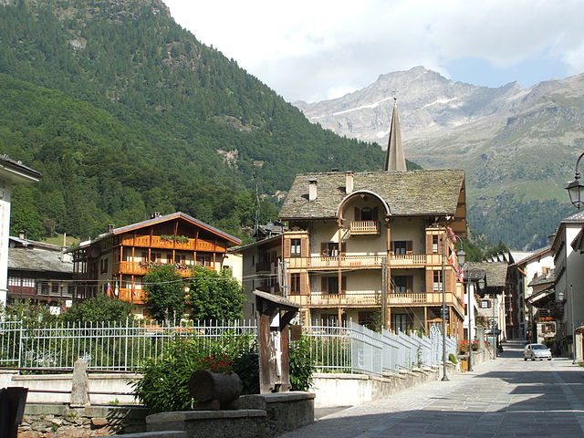
Gressoney-La-Trinité (Gressoney-La-Trinité)
.svg)
- Italian comune
 Hiking in Gressoney-La-Trinité
Gressoney-La-Trinité is a charming village located in the Aosta Valley region of Italy, known for its stunning alpine scenery and a rich mix of Italian and Walser culture. It serves as a perfect base for hiking enthusiasts, offering a variety of trails suitable for different skill levels, from easy walks to more challenging hikes.
Hiking Trails
-
Lago di Gabiet: A relatively easy hike that leads to a beautiful alpine lake. The trail begins at the Gabiet lift station and offers breathtaking views of the surrounding mountains, making it suitable for families.
-
Monte Rosa: For more experienced hikers, trails leading towards Monte Rosa provide challenging terrain and stunning vistas. These routes can take you to higher altitudes, allowing for panoramic views of the mountain range.
-
Valle di Mascognaz: This is a picturesque valley offering several trails. You can enjoy the serene landscape, wildflowers, and possibly observe local wildlife. The trek is moderate and suitable for intermediate hikers.
-
Colle del Lys: A more demanding hike that rewards hikers with spectacular views. The path climbs toward the Colle del Lys, offering opportunities to see various mountain lakes and awe-inspiring vistas.
Tips for Hiking in Gressoney-La-Trinité
- Season: The best time for hiking is typically from late June to early October when the trails are clear of snow. Always check local conditions before heading out.
- Gear: Wear appropriate hiking boots, and don’t forget your trekking poles if you're tackling more challenging trails. Packing layers and waterproof gear is essential, as alpine weather can change quickly.
- Navigation: While many trails are well-marked, it's advisable to have a map or GPS device, particularly for longer or less-traveled routes.
- Safety: Always inform someone about your planned route and expected return. Carry a first aid kit, enough water, and snacks.
- Local Guides: Consider hiring a local guide if you’re unfamiliar with the terrain or looking for insights into the local flora, fauna, and culture.
Local Culture and Amenities
Gressoney-La-Trinité is also known for its rich Walser heritage, which you can explore while hiking. You may find small chapels, traditional farms, and cultural landmarks along certain trails. After a day of hiking, enjoy local cuisine in one of the village's restaurants, featuring dishes influenced by both Italian and Alpine traditions.
Whether you’re looking for a leisurely hike or a more adventurous trek, Gressoney-La-Trinité offers a captivating blend of natural beauty and cultural experiences, making it an excellent destination for all types of hikers.
- Country:

- Postal Code: 11020
- Local Dialing Code: 0125
- Licence Plate Code: AO
- Coordinates: 45° 50' 0" N, 7° 50' 0" E


- GPS tracks (wikiloc): [Link]
- AboveSeaLevel: 1635 м m
- Area: 66.52 sq km
- Population: 300
- Web site: http://www.comune.gressoneylatrinite.ao.it/
- Wikipedia en: wiki(en)
- Wikipedia: wiki(it)
- Wikidata storage: Wikidata: Q35077
- Wikipedia Commons Gallery: [Link]
- Wikipedia Commons Category: [Link]
- Wikipedia Commons Maps Category: [Link]
- Freebase ID: [/m/0ft0cp]
- GeoNames ID: Alt: [6535873]
- VIAF ID: Alt: [132724215]
- OSM relation ID: [2528]
- GND ID: Alt: [4022030-8]
- Library of Congress authority ID: Alt: [n2003035809]
- Treccani ID: [gressoney-la-trinite]
- ISTAT ID: 007032
- Italian cadastre code: E167
Shares border with regions:
Alagna Valsesia
- Italian comune
Hiking in Alagna Valsesia
Alagna Valsesia, located in the Valsesia valley in the Piedmont region of Italy, is a fantastic destination for hiking enthusiasts. Nestled in the foothills of the Monte Rosa massif, it offers breathtaking landscapes, diverse trails, and a wealth of natural beauty....
- Country:
- Postal Code: 13021
- Local Dialing Code: 0163
- Licence Plate Code: VC
- Coordinates: 45° 51' 14" N, 7° 56' 14" E
- GPS tracks (wikiloc): [Link]
- AboveSeaLevel: 1154 м m
- Area: 133.17 sq km
- Population: 430
- Web site: [Link]


Zermatt
- municipality in Visp district, canton of Valais, Switzerland
Hiking in Zermatt
Zermatt, located in the Swiss Alps, is a stunning destination for hiking enthusiasts. This charming car-free village, nestled at the foot of the iconic Matterhorn, offers a range of hiking trails for all skill levels, providing breathtaking views and a chance to explore the unique Alpine landscape....
- Country:

- Postal Code: 3920
- Local Dialing Code: 027
- Licence Plate Code: VS
- Coordinates: 45° 59' 23" N, 7° 45' 10" E
- GPS tracks (wikiloc): [Link]
- AboveSeaLevel: 2621 м m
- Area: 242.67 sq km
- Population: 5643
- Web site: [Link]


Ayas, Aosta Valley
- Italian comune
Hiking in Ayas, Aosta Valley
Ayas, located in the Aosta Valley region of Italy, is a stunning area known for its picturesque landscapes, charming alpine villages, and a variety of hiking trails that cater to different experience levels. Here are some highlights and recommendations for hiking in Ayas:...
- Country:
- Postal Code: 11020
- Local Dialing Code: 0125
- Licence Plate Code: AO
- Coordinates: 45° 48' 41" N, 7° 41' 12" E
- GPS tracks (wikiloc): [Link]
- AboveSeaLevel: 1698 м m
- Area: 129.42 sq km
- Population: 1377
- Web site: [Link]


Gressoney-Saint-Jean
- Italian comune
Hiking in Gressoney-Saint-Jean
Gressoney-Saint-Jean, located in the Aosta Valley of Italy, is a beautiful mountain village that offers excellent hiking opportunities in the scenic backdrop of the Alps. The area is particularly known for its stunning landscapes, featuring majestic peaks, lush valleys, and picturesque forests....
- Country:
- Postal Code: 11025
- Local Dialing Code: 0125
- Licence Plate Code: AO
- Coordinates: 45° 47' 0" N, 7° 49' 0" E
- GPS tracks (wikiloc): [Link]
- AboveSeaLevel: 1385 м m
- Area: 69.65 sq km
- Population: 818
- Web site: [Link]