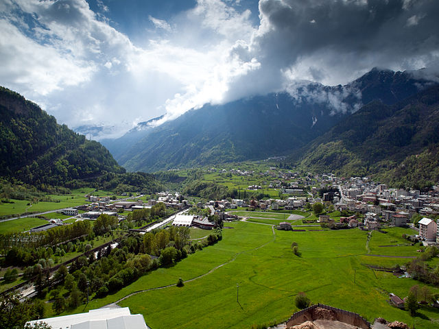
Grosio (Grosio)
.svg)
- Italian comune
 Hiking in Grosio
Grosio, located in the Valtellina valley of northern Italy, is a wonderful destination for hiking enthusiasts. Surrounded by the stunning Rhaetian Alps, the area offers a variety of trails that cater to different skill levels, from casual walkers to experienced hikers.
Highlights of Hiking in Grosio:
-
Diverse Terrain: The region features diverse landscapes, including lush forests, rocky terrains, and breathtaking alpine views. This diversity can make for stimulating hiking experiences.
-
Historical Significance: Along the trails, hikers can discover historical sites such as the ancient rock engravings in the area. The "Parco Nazionale dello Stelvio," which is in proximity, can also be explored for a glimpse into the region's history.
-
Recommended Trails:
- The Trail to Parco delle Incisioni Rupestri: This moderate trail leads to the incredible rock engravings that date back thousands of years.
- Bivacco Alpe Foppa: This route offers a moderate challenge with beautiful views of the surrounding mountains and valleys.
- Sentiero dei Contrabbandieri: A more challenging hike that follows a historical smuggler’s path with breathtaking vistas.
-
Flora and Fauna: The region is rich in wildlife and plant species. You might encounter a variety of birds and possibly deer or ibex in higher elevations.
-
Accessibility: Grosio is well-connected by public transportation, making it relatively easy to reach for day hikes. There are also local guides and organizations that can assist with trail recommendations and guided hikes.
-
Best Time to Hike: The ideal months for hiking are late spring to early fall (May to September), when the weather is generally favorable and the trails are clear of snow.
Tips for Hiking in Grosio:
- Preparation: Always check the weather forecast before heading out and choose trails suitable for your fitness level. Carry enough water, snacks, and a fully charged phone.
- Footwear: Wear sturdy hiking boots to support your feet on rocky or uneven terrain.
- Local Guidelines: Be aware of local guidelines regarding wildlife and trail etiquette to preserve the natural beauty of the area.
Whether you're looking for a peaceful walk in nature or a challenging adventure, Grosio has a lot to offer every hiker!
- Country:

- Postal Code: 23033
- Local Dialing Code: 0342
- Licence Plate Code: SO
- Coordinates: 46° 18' 0" N, 10° 17' 0" E


- GPS tracks (wikiloc): [Link]
- AboveSeaLevel: 656 м m
- Area: 126.92 sq km
- Population: 4431
- Web site: http://www.comune.grosio.so.it
- Wikipedia en: wiki(en)
- Wikipedia: wiki(it)
- Wikidata storage: Wikidata: Q40653
- Wikipedia Commons Category: [Link]
- Freebase ID: [/m/0gj34s]
- GeoNames ID: Alt: [6539473]
- VIAF ID: Alt: [130617177]
- OSM relation ID: [47094]
- GND ID: Alt: [4254706-4]
- archINFORM location ID: [45546]
- WOEID: [716426]
- ISTAT ID: 014033
- Italian cadastre code: E200
Shares border with regions:

Monno
- Italian comune
Hiking in Monno
Monno, located in the province of Brescia in Italy, is an excellent destination for hiking enthusiasts. Nestled in the beautiful landscape of the Lombardy region, it offers a variety of trails suitable for different skill levels, from leisurely walks to more challenging hikes....
- Country:
- Postal Code: 25040
- Local Dialing Code: 0364
- Licence Plate Code: BS
- Coordinates: 46° 12' 48" N, 10° 20' 26" E
- GPS tracks (wikiloc): [Link]
- AboveSeaLevel: 1066 м m
- Area: 31.03 sq km
- Population: 540
- Web site: [Link]


Valdidentro
- Italian comune
Hiking in Valdidentro
Valdidentro is a beautiful valley located in the Lombardy region of northern Italy, within the larger Valtellina area. It's an excellent spot for hiking enthusiasts, offering a variety of trails that cater to different experience levels, stunning scenery, and opportunities to explore the rich natural and cultural heritage of the region....
- Country:
- Postal Code: 23038
- Local Dialing Code: 0342
- Licence Plate Code: SO
- Coordinates: 46° 29' 0" N, 10° 18' 0" E
- GPS tracks (wikiloc): [Link]
- AboveSeaLevel: 1345 м m
- Area: 226.73 sq km
- Population: 4131
- Web site: [Link]

Sondalo
- Italian comune
Hiking in Sondalo
Sondalo is a charming town located in the Valtellina Valley in northern Italy, surrounded by stunning natural landscapes that make it an excellent destination for hiking enthusiasts. The area is characterized by its dramatic mountains, lush forests, and rich biodiversity....
- Country:
- Postal Code: 23035
- Local Dialing Code: 0342
- Licence Plate Code: SO
- Coordinates: 46° 20' 0" N, 10° 20' 0" E
- GPS tracks (wikiloc): [Link]
- AboveSeaLevel: 900 м m
- Area: 95.45 sq km
- Population: 4114
- Web site: [Link]
Valdisotto
- Italian comune
Hiking in Valdisotto
Valdisotto is a beautiful destination located in the Valtellina region of Lombardy, Italy, known for its stunning landscapes, rich natural heritage, and excellent hiking opportunities. Nestled in the Alps, Valdisotto offers a range of trails that cater to hikers of all skill levels, from easy walks to challenging alpine routes....
- Country:
- Postal Code: 23030
- Local Dialing Code: 0342
- Licence Plate Code: SO
- Coordinates: 46° 25' 0" N, 10° 21' 0" E
- GPS tracks (wikiloc): [Link]
- AboveSeaLevel: 1141 м m
- Area: 89.57 sq km
- Population: 3601
- Web site: [Link]
Grosotto
- Italian comune
Hiking in Grosotto
Grosotto, located in the Valtellina valley of northern Italy, is a fantastic destination for hiking enthusiasts. Surrounded by stunning landscapes, this area offers a variety of trails that cater to all levels of hikers, from beginners to experienced mountaineers....
- Country:
- Postal Code: 23034
- Local Dialing Code: 0342
- Licence Plate Code: SO
- Coordinates: 46° 17' 0" N, 10° 16' 0" E
- GPS tracks (wikiloc): [Link]
- AboveSeaLevel: 610 м m
- Area: 53.12 sq km
- Population: 1624
- Web site: [Link]
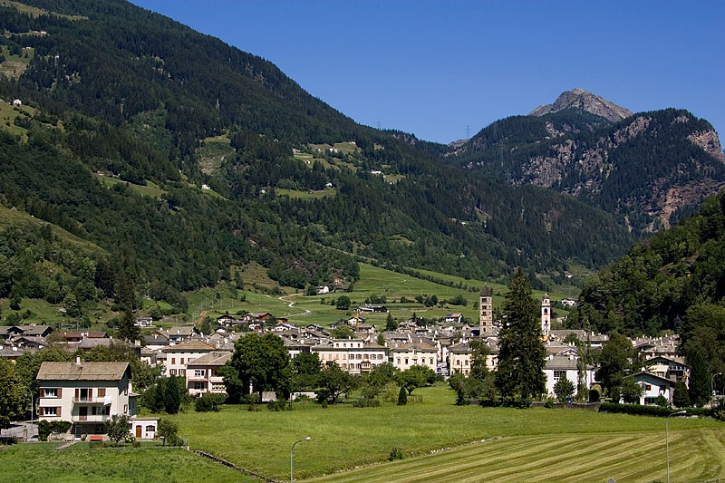
Poschiavo
- municipality in Switzerland
Hiking in Poschiavo
Poschiavo is a picturesque valley located in the eastern part of Switzerland, with stunning landscapes that make it an excellent destination for hiking enthusiasts. The valley is part of the canton of Graubünden and is known for its blend of Swiss and Italian cultures, reflected in its charming villages and local cuisine....
- Country:

- Postal Code: 7742; 7746; 7741; 7710; 7745
- Local Dialing Code: 081
- Licence Plate Code: GR
- Coordinates: 46° 20' 0" N, 10° 2' 59" E
- GPS tracks (wikiloc): [Link]
- AboveSeaLevel: 1014 м m
- Area: 191.01 sq km
- Population: 3516
- Web site: [Link]

Vezza d'Oglio
- Italian comune
Hiking in Vezza d'Oglio
Vezza d'Oglio is a charming town located in the Camonica Valley in the Lombardy region of northern Italy. It serves as a gateway to numerous hiking opportunities in the surrounding areas. Here are some highlights and tips for hiking around Vezza d'Oglio:...
- Country:
- Postal Code: 25059
- Local Dialing Code: 0364
- Licence Plate Code: BS
- Coordinates: 46° 14' 20" N, 10° 23' 53" E
- GPS tracks (wikiloc): [Link]
- AboveSeaLevel: 1080 м m
- Area: 54.15 sq km
- Population: 1443
- Web site: [Link]