Valdidentro (Valdidentro)
.svg)
- Italian comune
 Hiking in Valdidentro
Valdidentro is a beautiful valley located in the Lombardy region of northern Italy, within the larger Valtellina area. It's an excellent spot for hiking enthusiasts, offering a variety of trails that cater to different experience levels, stunning scenery, and opportunities to explore the rich natural and cultural heritage of the region.
Hiking Trails
-
Sentiero dei Fiori: This is a relatively easy trail that introduces hikers to the diverse flora of the area. It’s a great choice for families or those looking for a leisurely hike.
-
Valdidentro Panorama Trail: This moderate trail provides breathtaking views of the surrounding mountains and valleys. Perfect for moderate hikers, it allows for a closer connection with the local landscape.
-
Forni Glacier Route: For those seeking a more challenging adventure, this trail leads towards the Forni Glacier. It's a longer hike that involves gaining some elevation, but the views from the glacier are worth the effort.
-
Cima Piazzi Hike: This is a high-altitude hike that offers panoramic views of the Alps. Experienced hikers will appreciate the challenge of this trek.
Best Time to Hike
- Summer (June to September): The trails are usually clear of snow, and the weather is mild and pleasant, making it a great time for hiking.
- Autumn (October): The colors of the changing leaves can create stunning views, though do prepare for cooler temperatures.
Preparation and Gear
- Footwear: Good hiking boots are essential, preferably waterproof and with good ankle support.
- Clothing: Dress in layers. Weather can change rapidly in the mountains, so be prepared for various conditions.
- Navigation Tools: A map or GPS device is recommended, especially for less marked trails.
Safety Tips
- Always let someone know your hiking plans.
- Carry enough water and snacks.
- Be aware of your own limits and turn back if necessary.
- Check the weather forecast before heading out, and be prepared for sudden changes.
Local Highlights
- Wildlife: Keep an eye out for local wildlife such as deer, marmots, and various bird species.
- Cultural Sites: The area is rich in history; explore local villages and churches that reflect the traditional architecture and culture of the region.
Valdidentro provides a wonderful opportunity to enjoy the great outdoors while experiencing the natural beauty of the Italian Alps. Remember to tread lightly and respect the environment as you explore these stunning trails!
- Country:

- Postal Code: 23038
- Local Dialing Code: 0342
- Licence Plate Code: SO
- Coordinates: 46° 29' 0" N, 10° 18' 0" E


- GPS tracks (wikiloc): [Link]
- AboveSeaLevel: 1345 м m
- Area: 226.73 sq km
- Population: 4131
- Web site: http://www.comune.valdidentro.so.it/
- Wikipedia en: wiki(en)
- Wikipedia: wiki(it)
- Wikidata storage: Wikidata: Q40106
- Wikipedia Commons Category: [Link]
- Freebase ID: [/m/0gj40w]
- GeoNames ID: Alt: [3164854]
- OSM relation ID: [47189]
- ISTAT ID: 014071
- Italian cadastre code: L557
Shares border with regions:
Valdisotto
- Italian comune
Hiking in Valdisotto
Valdisotto is a beautiful destination located in the Valtellina region of Lombardy, Italy, known for its stunning landscapes, rich natural heritage, and excellent hiking opportunities. Nestled in the Alps, Valdisotto offers a range of trails that cater to hikers of all skill levels, from easy walks to challenging alpine routes....
- Country:
- Postal Code: 23030
- Local Dialing Code: 0342
- Licence Plate Code: SO
- Coordinates: 46° 25' 0" N, 10° 21' 0" E
- GPS tracks (wikiloc): [Link]
- AboveSeaLevel: 1141 м m
- Area: 89.57 sq km
- Population: 3601
- Web site: [Link]


Bormio
- Italian comune
Hiking in Bormio
Bormio is a beautiful town located in the Italian Alps, specifically within the Lombardy region. It's well known for its stunning landscapes, rich history, and access to a variety of outdoor activities, including hiking. Here’s an overview of what to expect when hiking in Bormio:...
- Country:
- Postal Code: 23032
- Local Dialing Code: 0342
- Licence Plate Code: SO
- Coordinates: 46° 28' 0" N, 10° 22' 0" E
- GPS tracks (wikiloc): [Link]
- AboveSeaLevel: 1225 м m
- Area: 41.44 sq km
- Population: 4194
- Web site: [Link]


Grosio
- Italian comune
Hiking in Grosio
Grosio, located in the Valtellina valley of northern Italy, is a wonderful destination for hiking enthusiasts. Surrounded by the stunning Rhaetian Alps, the area offers a variety of trails that cater to different skill levels, from casual walkers to experienced hikers....
- Country:
- Postal Code: 23033
- Local Dialing Code: 0342
- Licence Plate Code: SO
- Coordinates: 46° 18' 0" N, 10° 17' 0" E
- GPS tracks (wikiloc): [Link]
- AboveSeaLevel: 656 м m
- Area: 126.92 sq km
- Population: 4431
- Web site: [Link]


Livigno
- Italian comune
Hiking in Livigno
Livigno, located in the Italian Alps near the Swiss border, is a fantastic destination for hiking enthusiasts. This charming alpine resort is surrounded by stunning scenery, with lush valleys, high peaks, and pristine landscapes....
- Country:
- Postal Code: 23030
- Local Dialing Code: 0342
- Licence Plate Code: SO
- Coordinates: 46° 32' 0" N, 10° 8' 0" E
- GPS tracks (wikiloc): [Link]
- AboveSeaLevel: 1816 м m
- Area: 227.3 sq km
- Population: 6550
- Web site: [Link]

Zernez
- municipality in Switzerland
Hiking in Zernez
Zernez is a beautiful village located in the Swiss National Park in the Engadin Valley, known for its stunning natural landscapes, diverse ecosystems, and a variety of hiking trails that cater to different skill levels. Here are some highlights and tips for hiking in Zernez:...
- Country:

- Postal Code: 7530
- Local Dialing Code: 081
- Licence Plate Code: GR
- Coordinates: 46° 41' 59" N, 10° 5' 59" E
- GPS tracks (wikiloc): [Link]
- AboveSeaLevel: 2216 м m
- Area: 344.04 sq km
- Population: 1532
- Web site: [Link]
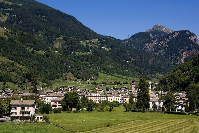
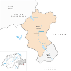
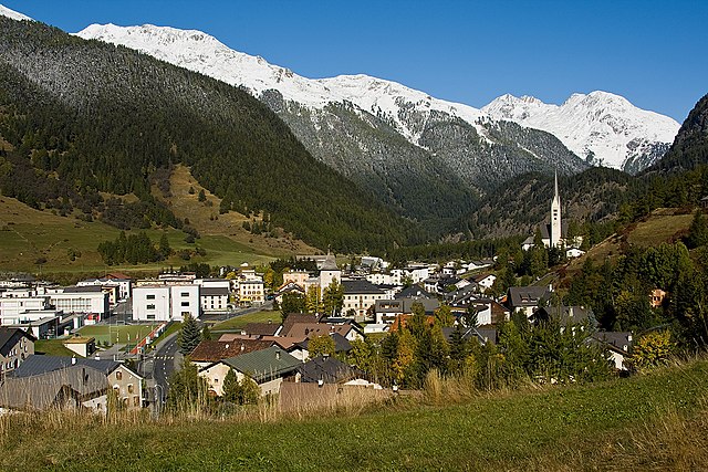
Poschiavo
- municipality in Switzerland
Hiking in Poschiavo
Poschiavo is a picturesque valley located in the eastern part of Switzerland, with stunning landscapes that make it an excellent destination for hiking enthusiasts. The valley is part of the canton of Graubünden and is known for its blend of Swiss and Italian cultures, reflected in its charming villages and local cuisine....
- Country:
- Postal Code: 7742; 7746; 7741; 7710; 7745
- Local Dialing Code: 081
- Licence Plate Code: GR
- Coordinates: 46° 20' 0" N, 10° 2' 59" E
- GPS tracks (wikiloc): [Link]
- AboveSeaLevel: 1014 м m
- Area: 191.01 sq km
- Population: 3516
- Web site: [Link]