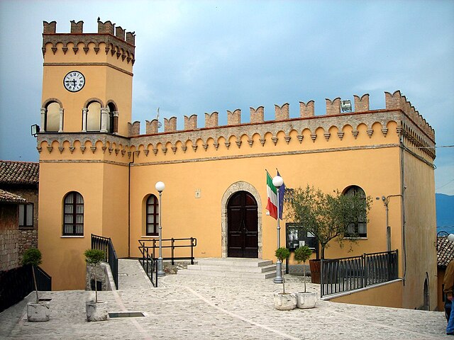
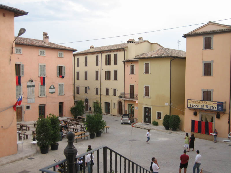
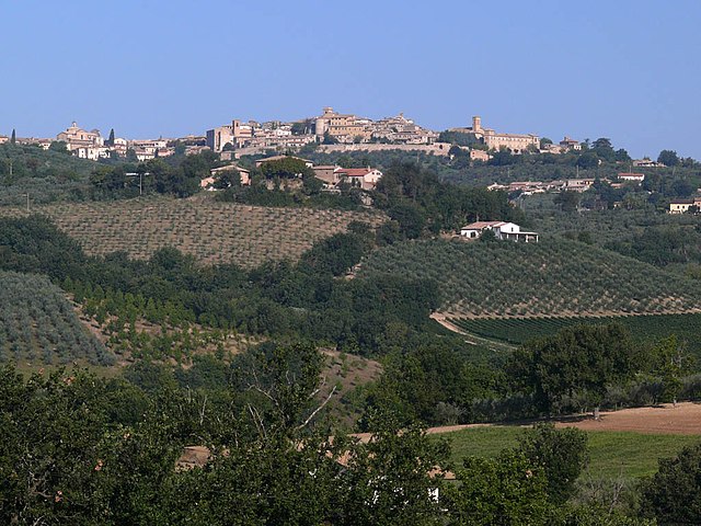
Gualdo Cattaneo (Gualdo Cattaneo)
.svg)
- Italian comune
 Hiking in Gualdo Cattaneo
Gualdo Cattaneo, a charming hilltop town in the Umbria region of Italy, offers several hiking opportunities that showcase its beautiful landscapes, rich history, and serene countryside. The area is characterized by rolling hills, vineyards, olive groves, and picturesque views, making it a great destination for outdoor enthusiasts.
Popular Hiking Routes
-
Sentiero della Valle: This trail takes you through lush valleys and offers stunning views of the surrounding hills. It's a moderately challenging hike, suitable for those looking to explore the natural beauty of the region.
-
Monte Castello di Vibio Loop: A hiking loop that leads you to the nearby village of Monte Castello di Vibio, known for its historical significance and charming architecture. The trail offers gentle inclines and beautiful panoramas, making it accessible for various skill levels.
-
Wine and Olive Oil Trails: Gualdo Cattaneo is located in an area renowned for its wineries and olive oil producers. Some trails wind through vineyards and olive groves, allowing hikers to enjoy tastings and learn about local production.
Tips for Hiking in Gualdo Cattaneo
-
Stay Hydrated: Always carry enough water, especially during the warmer months, as some trails may not have accessible water sources.
-
Footwear: Wear sturdy, comfortable hiking boots or shoes with good grip, as some paths can be steep or uneven.
-
Weather Check: Mountain weather can change quickly. Check the weather forecast and be prepared for varying conditions.
-
Local Guides: Consider hiring a local guide or joining a guided tour to enhance your experience and learn more about the area’s history and ecology.
-
Respect Nature: Follow Leave No Trace principles. Stay on marked trails and respect local wildlife.
Hiking in Gualdo Cattaneo offers not only physical activity but also a cultural experience, with opportunities to explore the delightful Umbrian countryside, historical landmarks, and perhaps even culinary delights that the region is famous for. Enjoy your hike!
- Country:

- Postal Code: 06035
- Local Dialing Code: 0742
- Licence Plate Code: PG
- Coordinates: 42° 55' 0" N, 12° 33' 0" E


- GPS tracks (wikiloc): [Link]
- AboveSeaLevel: 446 м m
- Area: 96.63 sq km
- Population: 5965
- Web site: http://www.comune.gualdocattaneo.pg.it
- Wikipedia en: wiki(en)
- Wikipedia: wiki(it)
- Wikidata storage: Wikidata: Q20453
- Wikipedia Commons Gallery: [Link]
- Wikipedia Commons Category: [Link]
- Freebase ID: [/m/0gm245]
- GeoNames ID: Alt: [6541886]
- VIAF ID: Alt: [125524123]
- OSM relation ID: [42198]
- GND ID: Alt: [4444191-5]
- Library of Congress authority ID: Alt: [n83041470]
- WOEID: [716477]
- UN/LOCODE: [ITGCT]
- ISTAT ID: 054022
- Italian cadastre code: E229
Shares border with regions:


Bettona
- Italian comune
Hiking in Bettona
Bettona, a charming medieval town located in the Umbria region of Italy, is not only known for its historic architecture and panoramic views but also offers wonderful hiking opportunities. The surrounding landscape provides a mix of rolling hills, vineyards, olive groves, and woods, making it a great destination for outdoor enthusiasts....
- Country:
- Postal Code: 06084
- Local Dialing Code: 075
- Licence Plate Code: PG
- Coordinates: 43° 1' 0" N, 12° 29' 0" E
- GPS tracks (wikiloc): [Link]
- AboveSeaLevel: 353 м m
- Area: 45.08 sq km
- Population: 4357
- Web site: [Link]


Bevagna
- Italian comune
Hiking in Bevagna
Bevagna is a charming medieval village located in the Umbria region of Italy, known for its rich history, picturesque landscapes, and beautiful rolling hills. While Bevagna itself may not be a well-known hiking destination like some of its neighboring areas (like Assisi or the Sibillini Mountains), it does offer opportunities for hiking and exploring the breathtaking countryside....
- Country:
- Postal Code: 06031
- Local Dialing Code: 0742
- Licence Plate Code: PG
- Coordinates: 42° 56' 0" N, 12° 37' 0" E
- GPS tracks (wikiloc): [Link]
- AboveSeaLevel: 210 м m
- Area: 56.22 sq km
- Population: 5013
- Web site: [Link]


Cannara
- Italian comune
Hiking in Cannara
Cannara is a charming town located in the Umbria region of Italy, surrounded by beautiful landscapes that offer a variety of hiking opportunities. Here’s an overview of what you can expect when hiking in and around Cannara:...
- Country:
- Postal Code: 06033
- Local Dialing Code: 0742
- Licence Plate Code: PG
- Coordinates: 43° 0' 0" N, 12° 35' 0" E
- GPS tracks (wikiloc): [Link]
- AboveSeaLevel: 197 м m
- Area: 32.81 sq km
- Population: 4337
- Web site: [Link]


Collazzone
- Italian comune
Hiking in Collazzone
Collazzone, located in the Umbria region of Italy, offers a beautiful setting for hiking enthusiasts. Nestled in the Italian countryside, this charming hilltop village is surrounded by lush landscapes, vineyards, and olive groves, providing a picturesque backdrop for various outdoor activities....
- Country:
- Postal Code: 06050
- Local Dialing Code: 075
- Licence Plate Code: PG
- Coordinates: 42° 54' 0" N, 12° 26' 0" E
- GPS tracks (wikiloc): [Link]
- AboveSeaLevel: 469 м m
- Area: 55.68 sq km
- Population: 3448
- Web site: [Link]

Giano dell'Umbria
- Italian comune
Hiking in Giano dell'Umbria
Giano dell'Umbria, located in the heart of Umbria, Italy, is a picturesque destination that offers a unique blend of hiking opportunities and breathtaking landscapes. Here’s an overview of what you can expect when hiking in this charming area:...
- Country:
- Postal Code: 06030
- Local Dialing Code: 0742
- Licence Plate Code: PG
- Coordinates: 42° 50' 0" N, 12° 35' 0" E
- GPS tracks (wikiloc): [Link]
- AboveSeaLevel: 547 м m
- Area: 44.48 sq km
- Population: 3893
- Web site: [Link]

Massa Martana
- Italian comune
Hiking in Massa Martana
Massa Martana, located in the province of Terni in Italy's Umbria region, is a beautiful destination for hiking enthusiasts. The area is characterized by its lush landscapes, rolling hills, and rich historical significance, which makes it an excellent spot for outdoor adventures....
- Country:
- Postal Code: 06056
- Local Dialing Code: 075
- Licence Plate Code: PG
- Coordinates: 42° 47' 0" N, 12° 31' 0" E
- GPS tracks (wikiloc): [Link]
- AboveSeaLevel: 351 м m
- Area: 78.41 sq km
- Population: 3742
- Web site: [Link]

Montefalco
- Italian comune
Hiking in Montefalco
Montefalco, often referred to as the "Balcony of Umbria," is a beautiful hilltop town in central Italy known for its stunning panoramic views, rich history, and excellent wine, particularly the Sagrantino. Hiking in and around Montefalco offers a unique combination of natural beauty, cultural experiences, and culinary delights....
- Country:
- Postal Code: 06036
- Local Dialing Code: 0742
- Licence Plate Code: PG
- Coordinates: 42° 53' 27" N, 12° 38' 54" E
- GPS tracks (wikiloc): [Link]
- AboveSeaLevel: 473 м m
- Area: 69.51 sq km
- Population: 5577
- Web site: [Link]


Todi
- Italian comune
Hiking in Todi
Todi, a picturesque medieval town in the Umbria region of Italy, offers a range of hiking opportunities that allow you to explore its stunning natural landscapes and rich cultural heritage. Here are some key points to consider if you're planning to hike in Todi:...
- Country:
- Postal Code: 06059
- Local Dialing Code: 075
- Licence Plate Code: PG
- Coordinates: 42° 47' 0" N, 12° 25' 0" E
- GPS tracks (wikiloc): [Link]
- AboveSeaLevel: 410 м m
- Area: 222.86 sq km
- Population: 16606
- Web site: [Link]