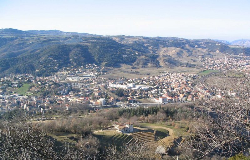
Guilherand-Granges (Guilherand-Granges)
- commune in Ardèche, France
 Hiking in Guilherand-Granges
Guilherand-Granges, located in the Auvergne-Rhône-Alpes region of France, offers some beautiful hiking opportunities, especially considering its proximity to the Rhône River and the stunning landscapes of the Ardèche department. Here are some highlights of hiking in and around Guilherand-Granges:
Trails and Scenery
-
River Trails: The banks of the Rhône River feature various walking paths that provide picturesque views. You can enjoy easy hikes along the water, perfect for beginners and families.
-
Nature Parks: Nearby nature reserves and parks like the Parc Naturel Régional des Monts d'Ardèche offer more challenging hikes with rugged terrain, diverse flora and fauna, and panoramic views.
-
Vineyard Routes: The region is also known for its vineyards, and you can find trails that take you through beautiful vineyards and orchards, offering a chance to taste local wines.
-
Historic Sites: Some trails may lead to historical sites, such as castles and old villages, providing cultural enrichment along with the natural beauty.
Hiking Tips
- Trail Maps: It's advisable to have a detailed map of the trails. Local tourist information centers can provide maps and additional resources.
- Weather Considerations: Check the weather conditions before you head out, as it can change rapidly in the mountains.
- Gear Up: Wear sturdy hiking boots and appropriate clothing, especially if you plan on exploring rugged or uneven terrain.
- Stay Hydrated: Carry enough water and snacks, particularly on longer trails.
Accessibility
Guilherand-Granges is well-connected, making it accessible for both local and visiting hikers. If you're traveling from other parts of France, it's possible to drive or take public transport to reach this charming town and its surrounding hiking areas.
Local Recommendations
- Engage with local hiking clubs or groups for guided hikes or additional recommendations.
- After a day of hiking, explore local restaurants to enjoy some regional cuisine.
Whether you're looking for a leisurely stroll by the river or an adventurous trek in the mountains, Guilherand-Granges can provide a satisfying hiking experience for everyone!
- Country:

- Postal Code: 07500
- Coordinates: 44° 56' 4" N, 4° 52' 29" E


- GPS tracks (wikiloc): [Link]
- AboveSeaLevel: 123 м m
- Area: 6.55 sq km
- Population: 10862
- Web site: http://www.ville-guilherand-granges.fr/
- Wikipedia en: wiki(en)
- Wikipedia: wiki(fr)
- Wikidata storage: Wikidata: Q274292
- Wikipedia Commons Category: [Link]
- Freebase ID: [/m/03ckrpx]
- GeoNames ID: Alt: [6615764]
- SIREN number: [210701025]
- VIAF ID: Alt: [146746186]
- GND ID: Alt: [16061082-5]
- PACTOLS thesaurus ID: [pcrt9jYOqkfon2]
- Twitter username: Alt: [villedeGGranges]
- INSEE municipality code: 07102
Shares border with regions:
Saint-Péray
- commune in Ardèche, France
Hiking in Saint-Péray
Saint-Péray, located in the Auvergne-Rhône-Alpes region of France, is a charming destination for hiking enthusiasts. Nestled near the Rhône River and surrounded by picturesque vineyards and rolling hills, it offers a variety of trails that cater to different skill levels....
- Country:
- Postal Code: 07130
- Coordinates: 44° 56' 55" N, 4° 50' 42" E
- GPS tracks (wikiloc): [Link]
- AboveSeaLevel: 128 м m
- Area: 24.05 sq km
- Population: 7572
- Web site: [Link]


Bourg-lès-Valence
- commune in Drôme, France
Hiking in Bourg-lès-Valence
Bourg-lès-Valence is a charming town located in the Auvergne-Rhône-Alpes region of France, situated near the banks of the Rhône River. While it may not be a major hiking destination in itself, its proximity to the surrounding natural landscapes makes it a great starting point for various hiking opportunities....
- Country:
- Postal Code: 26500
- Coordinates: 44° 56' 51" N, 4° 53' 43" E
- GPS tracks (wikiloc): [Link]
- Area: 20.3 sq km
- Population: 20074
- Web site: [Link]
Soyons
- commune in Ardèche, France
Hiking in Soyons
Soyons is a charming village located in the Auvergne-Rhône-Alpes region of France, near the city of Valence. It offers a variety of scenic landscapes ideal for hiking enthusiasts. Here are some features and suggestions for hiking in and around Soyons:...
- Country:
- Postal Code: 07130
- Coordinates: 44° 53' 21" N, 4° 51' 1" E
- GPS tracks (wikiloc): [Link]
- Area: 7.9 sq km
- Population: 2211
- Web site: [Link]

Toulaud
- commune in Ardèche, France
Hiking in Toulaud
Toulaud is a picturesque commune located in the Auvergne-Rhône-Alpes region of France, specifically in the Ardèche department. It's known for its beautiful landscapes, rolling hills, and natural beauty, making it a great destination for hiking enthusiasts....
- Country:
- Postal Code: 07130
- Coordinates: 44° 53' 52" N, 4° 48' 59" E
- GPS tracks (wikiloc): [Link]
- Area: 34.73 sq km
- Population: 1674


Valence
- commune in Drôme, France
Hiking in Valence
Valence, located in the Rhône-Alpes region of France, offers a wonderful base for hiking enthusiasts. While the city itself is more urban, it is surrounded by natural attractions and landscapes perfect for hiking....
- Country:
- Postal Code: 26000
- Coordinates: 44° 55' 57" N, 4° 53' 27" E
- GPS tracks (wikiloc): [Link]
- Area: 36.69 sq km
- Population: 62479
- Web site: [Link]