Höxter (Kreis Höxter)

- German district in North Rhine-Westphalia
 Hiking in Höxter
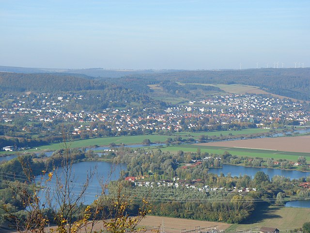
Höxter is a picturesque district located in North Rhine-Westphalia, Germany, known for its stunning landscapes, historical sites, and outdoor activities, making it an excellent destination for hiking enthusiasts. Here’s a comprehensive overview of hiking in the Höxter district:
Terrain and Scenery
Höxter features diverse terrain, including rolling hills, forests, and valleys. The region is characterized by the scenic landscapes along the Weser River, as well as the nearby Solling-Vogler Nature Park, which offers a variety of trails ranging from easy walks to more challenging hikes.
Popular Hiking Trails
-
Weserbergland Hiking Trail: This long-distance hike runs along the Weser River and through the surrounding hills. It offers breathtaking views, charming villages, and opportunities to explore local history and culture.
-
Solling-Höhenweg: This trail traverses the Solling region, showcasing the beautiful beech forests and offering panoramic views of the surrounding areas. It’s well-marked and varies in difficulty.
-
Biosphärenreservat Teutoburger Wald/Eggegebirge: This biosphere reserve includes several scenic trails that highlight the unique flora and fauna of the region. The landscape is perfect for nature lovers and those interested in biodiversity.
Attractions Along the Trails
While hiking in Höxter, you’ll encounter various points of interest, including:
- Historical Castles: Such as the Jagdschloss Dörnberg, which offers a glimpse into the region’s past.
- Towns and Villages: The medieval town of Höxter, with its half-timbered houses and historical architecture, is perfect for a rest stop.
- Cultural Sites: Visit local museums or art galleries that reflect the area’s rich history and culture.
Access and Facilities
- Wayfinding: Most trails are well-marked with signs and maps available at local tourist information centers.
- Accommodations: There are various lodging options, from hotels to guesthouses, catering to hikers seeking both comfort and convenience.
- Transport: The district is accessible by train and bus, making it easy to start your hike from various points.
Tips for Hiking in Höxter
- Seasonal Considerations: Spring and fall are ideal for hiking due to moderate weather and beautiful foliage. Summer is lovely too, but bring plenty of water.
- Gear: Standard hiking gear is advisable, including sturdy footwear, weather-appropriate clothing, and a daypack with essentials.
- Safety: Stay on marked trails, and carry a map or GPS device. Inform someone of your hiking plans for safety.
Conclusion
Hiking in the Höxter district offers a perfect blend of natural beauty, outdoor adventure, and cultural exploration. Whether you’re a seasoned hiker or someone looking to enjoy a leisurely walk in nature, Höxter has something to offer all adventurers. Enjoy your hike!
- Country:

- Capital: Höxter
- Licence Plate Code: HX
- Coordinates: 51° 40' 0" N, 9° 15' 0" E


- GPS tracks (wikiloc): [Link]
- AboveSeaLevel: 193 м m
- Web site: http://www.kreis-hoexter.de
- Wikipedia en: wiki(en)
- Wikipedia: wiki(de)
- Wikidata storage: Wikidata: Q6228
- Wikipedia Commons Gallery: [Link]
- Wikipedia Commons Category: [Link]
- Wikipedia Commons Maps Category: [Link]
- Freebase ID: [/m/01bf5x]
- GeoNames ID: Alt: [3231882]
- VIAF ID: Alt: [124972676]
- OSM relation ID: [62524]
- GND ID: Alt: [4025452-5]
- archINFORM location ID: [2461]
- Library of Congress authority ID: Alt: [n83059624]
- National Library of Israel ID: [000999702]
- NUTS code: [DEA44]
- German district key: 05762
Includes regions:
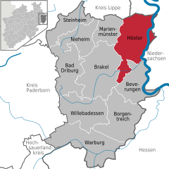
Höxter
- town in North Rhine-Westphalia, Germany, seat of the district of Höxter
Hiking in Höxter
Höxter is a charming town located in North Rhine-Westphalia, Germany, situated along the banks of the Weser River. It's surrounded by beautiful landscapes, making it an excellent destination for hiking enthusiasts. Here are some highlights about hiking in Höxter:...
- Country:
- Postal Code: 37671
- Local Dialing Code: 05531; 05278; 05277; 05275; 05271
- Licence Plate Code: HX
- Coordinates: 51° 46' 0" N, 9° 22' 0" E
- GPS tracks (wikiloc): [Link]
- AboveSeaLevel: 96 м m
- Area: 158.16 sq km
- Population: 29112
- Web site: [Link]

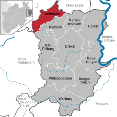
Steinheim
- municipality of Germany
Hiking in Steinheim
Steinheim, located in North Rhine-Westphalia, Germany, offers a charming backdrop for hiking enthusiasts. Nestled near the Teutoburg Forest and the surrounding countryside, the area is characterized by beautiful landscapes, diverse flora and fauna, and a mix of flat trails and hilly terrains....
- Country:
- Postal Code: 32839
- Local Dialing Code: 05284; 05238; 05233
- Licence Plate Code: HX
- Coordinates: 51° 51' 57" N, 9° 5' 40" E
- GPS tracks (wikiloc): [Link]
- AboveSeaLevel: 141 м m
- Area: 75.69 sq km
- Population: 12760
- Web site: [Link]

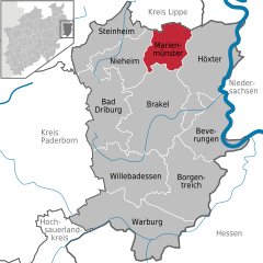
Marienmünster
- municipality of Germany
Hiking in Marienmünster
Marienmünster, located in Germany, is an excellent destination for hiking enthusiasts. Nestled in the picturesque Landschaftsverband Westfalen-Lippe region, it offers a variety of trails that cater to hikers of different skill levels and interests....
- Country:
- Postal Code: 37696
- Local Dialing Code: 05276
- Licence Plate Code: HX
- Coordinates: 51° 49' 0" N, 9° 10' 59" E
- GPS tracks (wikiloc): [Link]
- AboveSeaLevel: 257 м m
- Area: 64.35 sq km
- Population: 5012
- Web site: [Link]


Nieheim
- municipality of Germany
Hiking in Nieheim
Nieheim, located in North Rhine-Westphalia, Germany, offers a charming setting for hiking enthusiasts. Nestled in the Teutoburg Forest, it's surrounded by beautiful landscapes, including wooded hills, rolling fields, and picturesque villages. Here are some key points about hiking in Nieheim:...
- Country:
- Postal Code: 33039
- Local Dialing Code: 05284; 05276; 05274; 05238; 05233
- Licence Plate Code: HX
- Coordinates: 51° 47' 59" N, 9° 6' 35" E
- GPS tracks (wikiloc): [Link]
- AboveSeaLevel: 243 м m
- Area: 79.79 sq km
- Population: 6177
- Web site: [Link]

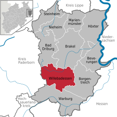
Willebadessen
- municipality of Germany
Hiking in Willebadessen
Willebadessen, located in North Rhine-Westphalia, Germany, is surrounded by beautiful landscapes ideal for hiking enthusiasts. Here are some highlights you might find interesting about hiking in the area:...
- Country:
- Postal Code: 34439; 34437; 34435
- Local Dialing Code: 05646; 05644; 05642
- Licence Plate Code: HX
- Coordinates: 51° 37' 59" N, 9° 1' 59" E
- GPS tracks (wikiloc): [Link]
- AboveSeaLevel: 295 м m
- Area: 128.41 sq km
- Population: 8227
- Web site: [Link]


Borgentreich
- municipality of Germany
Hiking in Borgentreich
Borgentreich, located in North Rhine-Westphalia, Germany, is a charming area for hiking enthusiasts. The region boasts diverse landscapes, including lush forests, rolling hills, and the scenic Naturpark Teutoburger Wald/Eggegebirge nearby. Here are some highlights and recommendations for hiking in Borgentreich:...
- Country:
- Postal Code: 34434
- Local Dialing Code: 05645; 05644; 05643
- Licence Plate Code: HX
- Coordinates: 51° 34' 9" N, 9° 14' 28" E
- GPS tracks (wikiloc): [Link]
- AboveSeaLevel: 205 м m
- Area: 138.94 sq km
- Population: 8669
- Web site: [Link]

Beverungen
- municipality of Germany
Hiking in Beverungen
Beverungen, located in North Rhine-Westphalia, Germany, offers a variety of hiking opportunities for outdoor enthusiasts. The region is characterized by its scenic landscapes, including rolling hills, wooded areas, and the nearby Weser River, making it a beautiful area to explore....
- Country:
- Postal Code: 37688
- Local Dialing Code: 05273
- Licence Plate Code: HX
- Coordinates: 51° 39' 46" N, 9° 22' 21" E
- GPS tracks (wikiloc): [Link]
- AboveSeaLevel: 100 м m
- Area: 97.84 sq km
- Population: 13176
- Web site: [Link]


Brakel
- city in Germany
Hiking in Brakel
Brakel, located in North Rhine-Westphalia, Germany, is a charming town surrounded by beautiful landscapes, making it an excellent destination for hiking enthusiasts. The area offers a variety of trails that cater to different skill levels and interests....
- Country:
- Postal Code: 33034
- Local Dialing Code: 05645; 05276; 05648; 05272
- Licence Plate Code: HX
- Coordinates: 51° 43' 0" N, 9° 11' 0" E
- GPS tracks (wikiloc): [Link]
- AboveSeaLevel: 135 м m
- Area: 173.74 sq km
- Population: 16374
- Web site: [Link]


Bad Driburg
- municipality of Germany
Hiking in Bad Driburg
Bad Driburg, located in North Rhine-Westphalia, Germany, offers a delightful hiking experience with its scenic landscapes and well-marked trails. The area is characterized by rolling hills, lush forests, and picturesque views that appeal to both casual walkers and seasoned hikers....
- Country:
- Postal Code: 33014
- Local Dialing Code: 05259; 05253; 05238
- Licence Plate Code: HX
- Coordinates: 51° 44' 0" N, 9° 1' 0" E
- GPS tracks (wikiloc): [Link]
- AboveSeaLevel: 220 м m
- Area: 115.3 sq km
- Population: 18930
- Web site: [Link]


Warburg
- town in North Rhine-Westphalia, Germany
Hiking in Warburg
Warburg, located in North Rhine-Westphalia, Germany, is a charming town that offers a variety of hiking opportunities, primarily in the surrounding natural landscapes such as the Teutoburg Forest and the diverse countryside of the region. Here are some highlights for hikers in and around Warburg:...
- Country:
- Postal Code: 34414
- Local Dialing Code: 05642; 05641
- Licence Plate Code: HX
- Coordinates: 51° 29' 17" N, 9° 8' 24" E
- GPS tracks (wikiloc): [Link]
- AboveSeaLevel: 230 м m
- Area: 168.84 sq km
- Population: 23128
- Web site: [Link]
Shares border with regions:
Hochsauerlandkreis
- district in North Rhine-Westphalia, Germany
Hiking in Hochsauerlandkreis
Hochsauerlandkreis, located in North Rhine-Westphalia, Germany, is known for its stunning natural landscapes and well-marked hiking trails. The area is characterized by rolling hills, dense forests, and picturesque villages, making it a great destination for hikers of all experience levels....
- Country:
- Licence Plate Code: HSK
- Coordinates: 51° 17' 57" N, 8° 20' 33" E
- GPS tracks (wikiloc): [Link]
- AboveSeaLevel: 577 м m
- Area: 1958.78 sq km
- Population: 268851
- Web site: [Link]


Holzminden
- district in Lower Saxony, Germany
Hiking in Holzminden
Holzminden is a picturesque district in Lower Saxony, Germany, characterized by its stunning landscapes, lush forests, and scenic river valleys. It’s an excellent destination for hiking enthusiasts of all levels. Here are some highlights about hiking in Holzminden:...
- Country:
- Licence Plate Code: HOL
- Coordinates: 51° 49' 48" N, 9° 30' 0" E
- GPS tracks (wikiloc): [Link]
- AboveSeaLevel: 177 м m
- Area: 692.00 sq km
- Population: 71510
- Web site: [Link]


Northeim
- district in Lower Saxony, Germany
Hiking in Northeim
Northeim is a lovely district located in Lower Saxony, Germany, known for its scenic landscapes and variety of hiking opportunities. The region is characterized by a mix of forests, hills, and rivers, making it a great destination for outdoor enthusiasts....
- Country:
- Licence Plate Code: NOM; GAN; EIN
- Coordinates: 51° 45' 0" N, 9° 49' 48" E
- GPS tracks (wikiloc): [Link]
- AboveSeaLevel: 149 м m
- Area: 1267.00 sq km
- Population: 133610
- Web site: [Link]
Paderborn
- German district of North Rhine-Westphalia
Hiking in Paderborn
Paderborn, located in North Rhine-Westphalia, Germany, offers a variety of hiking opportunities, combining natural beauty with cultural landmarks. The region is characterized by its mix of forests, parks, and scenic countryside, making it a pleasant destination for both casual walkers and more experienced hikers....
- Country:
- Licence Plate Code: PB
- Coordinates: 51° 42' 36" N, 8° 44' 24" E
- GPS tracks (wikiloc): [Link]
- AboveSeaLevel: 221 м m
- Area: 1246.8 sq km
- Web site: [Link]


Lippe
- German district in North Rhine-Westphalia
Hiking in Lippe
Lippe, located in North Rhine-Westphalia, Germany, is known for its picturesque landscapes, historical sites, and diverse hiking opportunities. Here are some key points to consider if you’re planning a hiking trip in the Lippe district:...
- Country:
- Licence Plate Code: LIP
- Coordinates: 52° 0' 0" N, 8° 55' 0" E
- GPS tracks (wikiloc): [Link]
- AboveSeaLevel: 129 м m
- Web site: [Link]