Northeim (Landkreis Northeim)
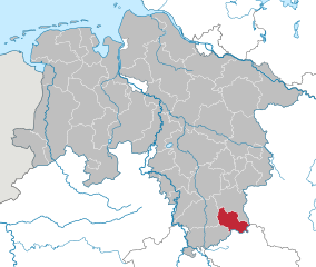
- district in Lower Saxony, Germany
Northeim is a lovely district located in Lower Saxony, Germany, known for its scenic landscapes and variety of hiking opportunities. The region is characterized by a mix of forests, hills, and rivers, making it a great destination for outdoor enthusiasts.
Hiking Trails
-
Harz National Park: While not entirely within the Northeim district, the nearby Harz National Park offers a wealth of hiking trails suited for all levels of experience. The park, known for its rugged terrain and dense forests, features trails like the Brocken summit trail, which is a must for hiking enthusiasts.
-
Sülzberg and the surrounding area: The hills around Northeim offer several well-maintained trails that provide beautiful views and a chance to explore the local flora and fauna. You can find trails that vary in length and difficulty, making it a great place for both casual walkers and experienced hikers.
-
Leine River Trail: This is a scenic long-distance trail that follows the Leine River and passes through Northeim. It's a fantastic choice for those who prefer a more relaxed trek along the water, with opportunities to stop and enjoy the landscapes.
Scenic Highlights
- Natural Beauty: The region boasts picturesque views of rolling hills and lush forests, especially in the autumn when the foliage changes color.
- Historic Towns: Along the hiking paths, you'll encounter charming towns with historical buildings, such as Northeim itself, which offers quaint streets and local culture.
Tips for Hiking in Northeim
- Trail Maps: Make sure to obtain a good trail map or use a hiking app to help navigate the area.
- Weather: Check the weather forecast before you head out, particularly during the rainy season, as paths can become muddy.
- Gear: Wear appropriate hiking gear, including sturdy shoes and layers, as temperatures can fluctuate.
- Local Regulations: Be mindful of any local regulations regarding trail usage and wildlife protection.
Conclusion
Hiking in Northeim offers an excellent way to experience the natural beauty and tranquility of Lower Saxony. Whether you're tackling the rugged trails of the Harz or enjoying a leisurely walk along the Leine River, there's something for everyone in this stunning region.
- Country:

- Licence Plate Code: NOM; GAN; EIN
- Coordinates: 51° 45' 0" N, 9° 49' 48" E


- GPS tracks (wikiloc): [Link]
- AboveSeaLevel: 149 м m
- Area: 1267.00 sq km
- Population: 133610
- Web site: http://www.landkreis-northeim.de/
- Wikipedia en: wiki(en)
- Wikipedia: wiki(de)
- Wikidata storage: Wikidata: Q6018
- Wikipedia Commons Gallery: [Link]
- Wikipedia Commons Category: [Link]
- Wikipedia Commons Maps Category: [Link]
- Freebase ID: [/m/014lwc]
- Freebase ID: [/m/014lwc]
- GeoNames ID: Alt: [3221015]
- GeoNames ID: Alt: [3221015]
- VIAF ID: Alt: [126866479]
- VIAF ID: Alt: [126866479]
- OSM relation ID: [62613]
- OSM relation ID: [62613]
- GND ID: Alt: [4042634-8]
- GND ID: Alt: [4042634-8]
- archINFORM location ID: [11040]
- archINFORM location ID: [11040]
- Library of Congress authority ID: Alt: [n2003054511]
- Library of Congress authority ID: Alt: [n2003054511]
- TGN ID: [7077046]
- TGN ID: [7077046]
- National Library of Israel ID: [001068261]
- National Library of Israel ID: [001068261]
- NUTS code: [DE918]
- NUTS code: [DE918]
- BabelNet ID: [00793799n]
- BabelNet ID: [00793799n]
- German district key: 03155
- German district key: 03155
Includes regions:


Northeim
- city in Lower Saxony, Germany
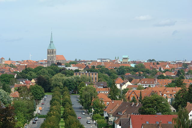
Northeim, located in Lower Saxony, Germany, offers a range of beautiful hiking opportunities set amidst scenic landscapes. The region is characterized by rolling hills, lush forests, and the picturesque scenery of the Harz foothills, making it ideal for outdoor adventures....
- Country:

- Postal Code: 37154
- Local Dialing Code: 05554; 05553; 05551; 05503
- Licence Plate Code: NOM
- Coordinates: 51° 42' 24" N, 10° 0' 4" E


- GPS tracks (wikiloc): [Link]
- AboveSeaLevel: 120 м m
- Area: 145.67 sq km
- Population: 28966
- Web site: [Link]
Shares border with regions:


Holzminden
- district in Lower Saxony, Germany
Holzminden is a picturesque district in Lower Saxony, Germany, characterized by its stunning landscapes, lush forests, and scenic river valleys. It’s an excellent destination for hiking enthusiasts of all levels. Here are some highlights about hiking in Holzminden:...
- Country:

- Licence Plate Code: HOL
- Coordinates: 51° 49' 48" N, 9° 30' 0" E


- GPS tracks (wikiloc): [Link]
- AboveSeaLevel: 177 м m
- Area: 692.00 sq km
- Population: 71510
- Web site: [Link]


Hildesheim
- district in Lower Saxony, Germany
Hildesheim is a beautiful district in Lower Saxony, Germany, known for its rich cultural heritage and scenic landscapes. While it may not be as famous for hiking as some other regions in Germany, there are still several great options for hikers of various skill levels....
- Country:

- Capital: Hildesheim
- Licence Plate Code: HI; ALF
- Coordinates: 52° 4' 48" N, 9° 55' 12" E


- GPS tracks (wikiloc): [Link]
- AboveSeaLevel: 80 м m
- Area: 1206.00 sq km
- Population: 277300
- Web site: [Link]


Göttingen district
- district in Lower Saxony, Germany
Göttingen, located in Lower Saxony, Germany, is surrounded by a variety of beautiful landscapes that are perfect for hiking enthusiasts. The district offers a mix of wooded areas, rolling hills, and scenic vistas, making it an excellent destination for hikers of all levels. Here are some highlights of hiking in the Göttingen district:...
- Country:

- Capital: Göttingen
- Licence Plate Code: GÖ; OHA; HMÜ; DUD
- Coordinates: 51° 30' 0" N, 9° 55' 12" E


- GPS tracks (wikiloc): [Link]
- AboveSeaLevel: 155 м m
- Area: 1117.00 sq km
- Population: 327065
- Web site: [Link]


Osterode
- former district in Lower Saxony, Germany
Osterode, located in the Lower Saxony region of Germany, offers a variety of hiking opportunities, particularly given its picturesque landscapes and proximity to the Harz Mountains. Here are some key points to consider for hiking in the Osterode district:...
- Country:

- Licence Plate Code: OHA
- Coordinates: 51° 40' 12" N, 10° 19' 48" E


- GPS tracks (wikiloc): [Link]
- AboveSeaLevel: 505 м m
- Area: 636.00 sq km
- Population: 75245
- Web site: [Link]


Goslar
- district in Lower Saxony, Germany
Goslar, located in Lower Saxony, Germany, is a beautiful area that offers a variety of hiking opportunities, particularly due to its proximity to the Harz Mountains. The district is known for its picturesque landscapes, medieval architecture, and rich history. Here are some highlights and suggestions for hiking in the Goslar district:...
- Country:

- Capital: Goslar
- Licence Plate Code: GS; CLZ; BRL
- Coordinates: 51° 54' 38" N, 10° 25' 16" E


- GPS tracks (wikiloc): [Link]
- AboveSeaLevel: 263 м m
- Area: 965.07 sq km
- Population: 137979
- Web site: [Link]


Höxter
- German district in North Rhine-Westphalia
Höxter is a picturesque district located in North Rhine-Westphalia, Germany, known for its stunning landscapes, historical sites, and outdoor activities, making it an excellent destination for hiking enthusiasts. Here’s a comprehensive overview of hiking in the Höxter district:...
- Country:

- Capital: Höxter
- Licence Plate Code: HX
- Coordinates: 51° 40' 0" N, 9° 15' 0" E


- GPS tracks (wikiloc): [Link]
- AboveSeaLevel: 193 м m
- Web site: [Link]

Kassel
- district in Hesse, Germany
Kassel, located in the northern part of Hesse, Germany, offers a variety of hiking trails that immerse you in nature and the area's rich cultural heritage. Here are some highlights to consider when hiking in and around Kassel:...
- Country:

- Capital: Kassel
- Licence Plate Code: WOH; HOG; KS
- Coordinates: 51° 18' 40" N, 9° 29' 9" E


- GPS tracks (wikiloc): [Link]
- AboveSeaLevel: 273 м m
- Area: 1292.76 sq km
- Population: 234206
- Web site: [Link]

