Hochsauerlandkreis (Hochsauerlandkreis)

- district in North Rhine-Westphalia, Germany
 Hiking in Hochsauerlandkreis
Hochsauerlandkreis, located in North Rhine-Westphalia, Germany, is known for its stunning natural landscapes and well-marked hiking trails. The area is characterized by rolling hills, dense forests, and picturesque villages, making it a great destination for hikers of all experience levels.
Key Features:
-
Diverse Trail Options:
- The region offers a range of hiking trails, from easy strolls to challenging hikes. Popular routes include segments of the Sauerland Höhenflug, a long-distance trail that offers breathtaking views of the surrounding countryside.
- There are also shorter circular trails suitable for families and those looking for a more leisurely hike.
-
Natural Parks and Reserves:
- The Rothaargebirge Nature Park is a highlight within the Hochsauerlandkreis. It features pristine landscapes, rich biodiversity, and beautiful viewpoints.
- The area is also home to several lakes, such as Bigge Lake and Diemelsee, where you can enjoy scenic walks along the water.
-
Cultural Landmarks:
- Many trails will take you past historical sites, charming villages, and local attractions. Don’t miss visiting places like the town of Winterberg, known for its winter sports but equally charming in the warmer months for hiking.
-
Seasonal Beauty:
- Each season offers a unique experience. Spring features blooming wildflowers, summer provides lush green landscapes, autumn showcases vibrant foliage, and winter can transform the area into a snowy wonderland for winter hiking.
-
Facilities and Amenities:
- The region is well-equipped for hikers, with plenty of accommodations, from hotels to guesthouses, as well as restaurants and cafes where you can rest and refuel after your hike.
Tips for Hiking in Hochsauerlandkreis:
- Plan Your Route: Before heading out, familiarize yourself with the trail maps and choose a route that matches your fitness level and time constraints.
- Weather Check: The weather can change quickly, especially in mountainous areas, so check ahead and be prepared for varying conditions.
- Gear Up: Wear appropriate hiking shoes and clothing, and don’t forget a backpack with water, snacks, and a first aid kit.
- Respect Nature: Stay on marked paths to protect the environment and enjoy the wildlife.
Whether you're a seasoned hiker or a novice, Hochsauerlandkreis offers a great hiking experience with varying levels of difficulty and beautiful landscapes to enjoy.
- Country:

- Licence Plate Code: HSK
- Coordinates: 51° 17' 57" N, 8° 20' 33" E


- GPS tracks (wikiloc): [Link]
- AboveSeaLevel: 577 м m
- Area: 1958.78 sq km
- Population: 268851
- Web site: http://www.hochsauerlandkreis.de/
- Wikipedia en: wiki(en)
- Wikipedia: wiki(de)
- Wikidata storage: Wikidata: Q5946
- Wikipedia Commons Gallery: [Link]
- Wikipedia Commons Category: [Link]
- Wikipedia Commons Maps Category: [Link]
- Freebase ID: [/m/018y42]
- GeoNames ID: Alt: [3221121]
- VIAF ID: Alt: [156603866]
- OSM relation ID: [62402]
- GND ID: Alt: [4025221-8]
- archINFORM location ID: [5924]
- Library of Congress authority ID: Alt: [n79081653]
- TGN ID: [7076829]
- National Library of Israel ID: [000976150]
- NUTS code: [DEA57]
- GNS Unique Feature ID: 115805
- German district key: 05958
Shares border with regions:

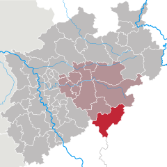
Märkischer Kreis
- district in central North Rhine-Westphalia, Germany
Hiking in Märkischer Kreis
Märkischer Kreis, located in North Rhine-Westphalia, Germany, is a beautiful region for hiking enthusiasts. It offers a blend of natural landscapes, charming small towns, and cultural heritage. Here are some highlights and things to know about hiking in this area:...
- Country:
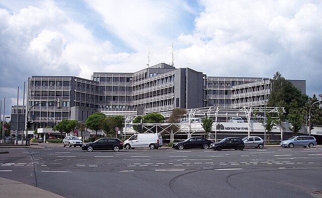
- Capital: Lüdenscheid
- Licence Plate Code: MK
- Coordinates: 51° 13' 30" N, 7° 36' 52" E
- GPS tracks (wikiloc): [Link]
- AboveSeaLevel: 186 м m
- Area: 1058.95 sq km
- Population: 416171
- Web site: [Link]
Olpe
- district in North Rhine-Westphalia, Germany
Hiking in Olpe
Olpe is a picturesque district located in the North Rhine-Westphalia region of Germany, known for its scenic landscapes, charming villages, and outdoor recreational opportunities, making it a great destination for hiking enthusiasts. Here are some key highlights about hiking in Olpe:...
- Country:
- Licence Plate Code: OE
- Coordinates: 51° 4' 48" N, 8° 0' 0" E
- GPS tracks (wikiloc): [Link]
- AboveSeaLevel: 334 м m
- Web site: [Link]
Soest
- district in North Rhine-Westphalia, Germany
Hiking in Soest
Soest is a district located in North Rhine-Westphalia, Germany, known for its scenic landscapes, historical sites, and outdoor recreational opportunities. Hiking in the Soest area can be a delightful experience due to its diverse terrain, including forests, hills, and waterways....
- Country:
- Licence Plate Code: SO
- Coordinates: 51° 34' 48" N, 8° 15' 0" E
- GPS tracks (wikiloc): [Link]
- AboveSeaLevel: 137 м m
- Web site: [Link]

Siegen-Wittgenstein
- district in North Rhine-Westphalia, Germany
Hiking in Siegen-Wittgenstein
Siegen-Wittgenstein is a beautiful region located in North Rhine-Westphalia, Germany, characterized by its lush landscapes, rolling hills, and dense forests. This area is perfect for hiking enthusiasts, offering a variety of trails suitable for all skill levels....
- Country:
- Licence Plate Code: BLB; SI
- Coordinates: 50° 55' 12" N, 8° 10' 12" E
- GPS tracks (wikiloc): [Link]
- AboveSeaLevel: 616 м m
- Area: 1132.89 sq km
- Population: 275909
- Web site: [Link]
Paderborn
- German district of North Rhine-Westphalia
Hiking in Paderborn
Paderborn, located in North Rhine-Westphalia, Germany, offers a variety of hiking opportunities, combining natural beauty with cultural landmarks. The region is characterized by its mix of forests, parks, and scenic countryside, making it a pleasant destination for both casual walkers and more experienced hikers....
- Country:
- Licence Plate Code: PB
- Coordinates: 51° 42' 36" N, 8° 44' 24" E
- GPS tracks (wikiloc): [Link]
- AboveSeaLevel: 221 м m
- Area: 1246.8 sq km
- Web site: [Link]

Höxter
- German district in North Rhine-Westphalia
Hiking in Höxter
Höxter is a picturesque district located in North Rhine-Westphalia, Germany, known for its stunning landscapes, historical sites, and outdoor activities, making it an excellent destination for hiking enthusiasts. Here’s a comprehensive overview of hiking in the Höxter district:...
- Country:
- Capital: Höxter
- Licence Plate Code: HX
- Coordinates: 51° 40' 0" N, 9° 15' 0" E
- GPS tracks (wikiloc): [Link]
- AboveSeaLevel: 193 м m
- Web site: [Link]