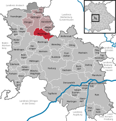
Hainsfarth (Hainsfarth)
- municipality of Germany
Hainsfarth, located in Bavaria, Germany, offers a charming setting for hiking enthusiasts. The region features picturesque landscapes, lush forests, and rolling hills that make for a great hiking experience. Here are some highlights and tips for hiking in Hainsfarth:
Trails
- Local Trails: Hainsfarth has several marked trails that vary in difficulty. You can find easy paths suitable for families and more challenging routes for experienced hikers.
- Scenic Views: Some trails offer beautiful views of the surrounding countryside, especially during the blooming season in spring and fall when colors are vibrant.
- Connecting Routes: Hainsfarth is often linked to larger hiking networks, giving you the opportunity to explore nearby areas.
Nature & Wildlife
- The region is rich in flora and fauna. Keep an eye out for local wildlife such as various bird species and small mammals.
- Autumn provides a particularly stunning backdrop as the leaves change color.
Equipment & Preparation
- Footwear: Ensure you have sturdy hiking boots with good grip, as some trails can be uneven or steep.
- Weather: Check the weather conditions before heading out, as they can change quickly in mountainous regions.
- Supplies: Carry plenty of water, snacks, and a map or a GPS device to help navigate the trails.
Local Amenities
- Hainsfarth is a small village, but nearby towns may offer accommodations, restaurants, and shops for supplies.
- Be sure to sample local Bavarian cuisine in nearby villages after your hike!
Safety Tips
- Always let someone know your hiking plans and estimated return time.
- Consider hiking with a companion, especially if you're unfamiliar with the trails.
- Follow local regulations and marked paths to preserve the natural environment.
Conclusion
Hiking in Hainsfarth is an excellent way to experience the beauty of the Bavarian countryside. With its variety of trails and stunning scenery, it's an inviting destination for both beginners and seasoned hikers. Enjoy your adventure!
- Country:

- Postal Code: 86744
- Local Dialing Code: 09082
- Licence Plate Code: DON
- Coordinates: 48° 58' 0" N, 10° 37' 0" E


- GPS tracks (wikiloc): [Link]
- AboveSeaLevel: 445 м m
- Area: 17.54 sq km
- Population: 1443
- Web site: http://www.hainsfarth.de/gemeinde/gemeinde.html
- Wikipedia en: wiki(en)
- Wikipedia: wiki(de)
- Wikidata storage: Wikidata: Q503773
- Wikipedia Commons Category: [Link]
- Freebase ID: [/m/02rbsn_]
- GeoNames ID: Alt: [6557281]
- VIAF ID: Alt: [132833911]
- OSM relation ID: [962604]
- GND ID: Alt: [4241452-0]
- Historical Gazetteer (GOV) ID: [HAIRT1JN58HX]
- Bavarikon ID: [ODB_A00000837]
- German municipality key: 09779154
Shares border with regions:
Megesheim
- municipality of Germany
Megesheim, located in Bavaria, Germany, is a charming village surrounded by beautiful natural landscapes, making it an ideal destination for hiking enthusiasts. The area offers a variety of trails that showcase the region's rolling hills, lush fields, and picturesque views....
- Country:

- Postal Code: 86750
- Local Dialing Code: 09082
- Licence Plate Code: DON
- Coordinates: 48° 56' 0" N, 10° 39' 0" E


- GPS tracks (wikiloc): [Link]
- AboveSeaLevel: 422 м m
- Area: 12.53 sq km
- Population: 753
- Web site: [Link]


Auhausen
- municipality of Germany
Auhausen, located in Germany, offers a picturesque setting for hiking enthusiasts. Nestled in the beautiful landscape of the Bavarian region, this area is characterized by rolling hills, lush forests, and scenic trails that cater to various skill levels....
- Country:

- Postal Code: 86736
- Local Dialing Code: 09832
- Licence Plate Code: DON
- Coordinates: 49° 1' 0" N, 10° 38' 0" E


- GPS tracks (wikiloc): [Link]
- AboveSeaLevel: 422 м m
- Area: 15.55 sq km
- Population: 992
- Web site: [Link]


Munningen
- municipality of Germany
Munningen is a small area located in the Bavarian region of Germany, near the Danube River. While it may not be as widely known as some larger hiking destinations, it offers beautiful landscapes and opportunities for outdoor activities, particularly for those who enjoy tranquility away from more crowded trails....
- Country:

- Postal Code: 86754
- Local Dialing Code: 0 90 82
- Licence Plate Code: DON
- Coordinates: 48° 55' 0" N, 10° 35' 0" E


- GPS tracks (wikiloc): [Link]
- AboveSeaLevel: 415 м m
- Area: 22.78 sq km
- Population: 1659
- Web site: [Link]


Westheim
- municipality of Germany
Westheim, located in Germany, is an area that typically offers a variety of outdoor activities including hiking. While it may not be as extensively covered as some of the more famous hiking regions in Germany, it possesses its own unique charm and natural beauty. Here are some aspects to consider if you're planning a hiking trip around Westheim:...
- Country:

- Postal Code: 91747
- Local Dialing Code: 09082
- Licence Plate Code: WUG
- Coordinates: 49° 0' 0" N, 10° 40' 0" E


- GPS tracks (wikiloc): [Link]
- AboveSeaLevel: 439 м m
- Area: 28.32 sq km
- Population: 1141
- Web site: [Link]


Oettingen in Bayern
- municipality of Germany
Oettingen in Bayern is a charming town located in the Swabian region of Bavaria, Germany. The area is characterized by its picturesque landscapes, rolling hills, and a rich historical backdrop, making it a great spot for hiking enthusiasts....
- Country:

- Postal Code: 86729–86732
- Local Dialing Code: 09082
- Licence Plate Code: DON
- Coordinates: 48° 57' 0" N, 10° 35' 0" E


- GPS tracks (wikiloc): [Link]
- AboveSeaLevel: 418 м m
- Area: 34.21 sq km
- Population: 4616
- Web site: [Link]

