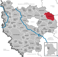
Heilsbronn (Heilsbronn)
- town in Germany
Heilsbronn, located in the region of Middle Franconia in Bavaria, Germany, offers a number of scenic hiking opportunities for outdoor enthusiasts. The area is known for its rolling hills, picturesque countryside, and historic sites, making it a great destination for both casual walkers and more experienced hikers. Here are some key points to consider when hiking in Heilsbronn:
Hiking Trails
-
Local Trails: Heilsbronn is surrounded by various hiking trails that showcase the natural beauty of the Franconian landscape. You can find well-marked paths that cater to different skill levels.
-
Franconian Switzerland: Located a bit further away, this region is famous for its unique sandstone formations, deep gorges, and rich flora and fauna, making it worth exploring while you're in the area.
-
Historical Trails: Some hikes in and around Heilsbronn lead to historical sites such as the Heilsbronn Monastery, which dates back to the 12th century. These routes provide a mix of nature and culture.
Preparation
-
Maps and Guides: It's a good idea to have a local hiking map or guidebook, as trail markings can vary. You might also consider downloading a hiking app that works offline.
-
Weather: Be sure to check the weather forecast before heading out, as conditions can change rapidly in this region. Dress in layers and be prepared for both sun and rain.
-
Footwear: Proper hiking boots or shoes are essential for navigating the trails comfortably and safely.
Safety Tips
- Always inform someone of your hiking plans, especially if venturing into less traveled areas.
- Carry enough water and snacks to stay hydrated and energized.
- Respect nature and stay on marked trails to protect the local wildlife.
Local Amenities
After a day of hiking, you can find charming cafes and restaurants in Heilsbronn to relax and enjoy some local Bavarian cuisine. It’s also a good idea to check for any local events or festivals that might be happening during your visit.
Hiking in Heilsbronn can be a rewarding experience, combining the beauty of nature with a touch of history. Enjoy your adventure!
- Country:

- Postal Code: 91560
- Local Dialing Code: 09872
- Licence Plate Code: AN
- Coordinates: 49° 20' 19" N, 10° 47' 27" E


- GPS tracks (wikiloc): [Link]
- AboveSeaLevel: 400 м m
- Area: 62.23 sq km
- Population: 7409
- Web site: http://www.heilsbronn.de
- Wikipedia en: wiki(en)
- Wikipedia: wiki(de)
- Wikidata storage: Wikidata: Q427153
- Wikipedia Commons Category: [Link]
- Freebase ID: [/m/07_2jw]
- GeoNames ID: Alt: [2907488]
- BnF ID: [144736080]
- VIAF ID: Alt: [158464339]
- OSM relation ID: [534382]
- GND ID: Alt: [4096113-8]
- archINFORM location ID: [13383]
- Library of Congress authority ID: Alt: [n2001065428]
- MusicBrainz area ID: [8e21e815-e0f8-4127-b8f2-16e3ac48d14f]
- WOEID: [658581]
- Historical Gazetteer (GOV) ID: [HEIONNJN59JH]
- Bavarikon ID: [ODB_A00000034]
- NKCR AUT ID: [ge894059]
- Catholic Encyclopedia ID: [07198b]
- German municipality key: 09571165
Shares border with regions:


Neuendettelsau
- municipality of Germany
Neuendettelsau is a charming village located in Bavaria, Germany, known for its picturesque landscapes and scenic hiking trails. The area offers a variety of hiking opportunities, suitable for different skill levels, from leisurely walks to more challenging treks....
- Country:

- Postal Code: 91564
- Local Dialing Code: 09874
- Licence Plate Code: AN
- Coordinates: 49° 16' 0" N, 10° 46' 0" E


- GPS tracks (wikiloc): [Link]
- AboveSeaLevel: 438 м m
- Area: 33.8 sq km
- Population: 6448
- Web site: [Link]


Dietenhofen
- municipality of Germany
Dietenhofen, located in Bavaria, Germany, is a great destination for hiking enthusiasts. The region boasts beautiful landscapes, charming villages, and a variety of trails suitable for different skill levels. Here are some key points to consider when hiking in and around Dietenhofen:...
- Country:

- Postal Code: 90599
- Local Dialing Code: 09824
- Licence Plate Code: AN
- Coordinates: 49° 24' 0" N, 10° 41' 24" E


- GPS tracks (wikiloc): [Link]
- AboveSeaLevel: 353 м m
- Area: 63.96 sq km
- Population: 4260
- Web site: [Link]


Petersaurach
- municipality of Germany
Petersaurach, located in Bavaria, Germany, is a charming area for hiking enthusiasts. The region is characterized by its beautiful landscapes, rolling hills, lush forests, and scenic trails that cater to various skill levels....
- Country:

- Postal Code: 91580
- Local Dialing Code: 0 98 72
- Licence Plate Code: AN
- Coordinates: 49° 17' 0" N, 10° 45' 0" E


- GPS tracks (wikiloc): [Link]
- AboveSeaLevel: 442 м m
- Area: 41.81 sq km
- Population: 3927
- Web site: [Link]

