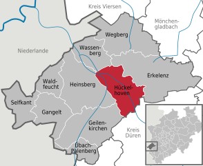
Heinsberg (Kreis Heinsberg)

- district in North Rhine-Westphalia, Germany
 Hiking in Heinsberg
Heinsberg, located in the northwestern part of North Rhine-Westphalia, Germany, offers a variety of hiking opportunities that cater to different skill levels and interests. The district is characterized by its picturesque landscape, which includes rolling hills, woodlands, and agricultural fields. Here are some key points to consider when hiking in Heinsberg:
Hiking Trails
-
Rurtal Hiking Trail: This scenic trail runs along the Rur River and provides beautiful views of the river landscapes and surrounding nature. It's suitable for both casual walkers and more experienced hikers.
-
Local Nature Trails: Heinsberg district features several well-marked local hiking paths that meander through forests, pastures, and small villages. These routes often provide insight into the local ecology and can be perfect for family hikes.
-
Heinsberg Circular Trails: There are specific circular trails that allow hikers to enjoy various landscapes within a manageable distance. These trails often range from 5 to 15 kilometers, making them ideal for day hikes.
Natural Attractions
- Birkenfeld Park: This area offers nice routes for leisurely hiking, with the added benefit of park facilities for relaxation.
- Nature Reserves: The district is home to several nature reserves where hikers can explore diverse flora and fauna, particularly in the wetlands and forested areas.
Seasonal Considerations
- Spring and Autumn: These seasons are especially beautiful for hiking in Heinsberg, as flora is vibrant in spring and the autumn colors can be stunning.
- Summer: Always ensure to carry enough water, as it's essential during warmer months when hiking for extended periods.
Preparation Tips
- Map and Apps: Consider bringing a map or using a hiking app to keep track of your route. Many local trails are well documented online.
- Gear: Proper footwear and weather-appropriate clothing are essential. Always check the local weather before heading out.
- Safety: Inform someone about your hiking plans, especially if you are hiking alone or on less-traveled paths.
Access and Amenities
- Public Transport: Heinsberg is accessible by public transport, so you can easily reach different trailheads.
- Facilities: Look for small villages along the routes where you can find cafés or restaurants for refreshments.
Overall, Heinsberg offers a delightful backdrop for hiking enthusiasts looking to explore the natural beauty of the region. Whether you prefer short leisurely walks or longer, more challenging hikes, you can find something that suits your experience level and interests.
- Country:

- Licence Plate Code: HS
- Coordinates: 51° 0' 0" N, 6° 10' 12" E


- GPS tracks (wikiloc): [Link]
- AboveSeaLevel: 38 м m
- Web site: http://www.kreis-heinsberg.de/
- Wikipedia en: wiki(en)
- Wikipedia: wiki(de)
- Wikidata storage: Wikidata: Q6264
- Wikipedia Commons Gallery: [Link]
- Wikipedia Commons Category: [Link]
- Wikipedia Commons Maps Category: [Link]
- Freebase ID: [/m/019gfb]
- GeoNames ID: Alt: [3247455]
- VIAF ID: Alt: [156584417]
- OSM relation ID: [62767]
- GND ID: Alt: [4024226-2]
- archINFORM location ID: [3365]
- Quora topic ID: [Heinsberg]
- Historical Gazetteer (GOV) ID: [adm_135370]
- ISNI: Alt: [0000 0004 0565 4484]
- NUTS code: [DEA29]
- Ringgold ID: [40185]
- German district key: 05370
Includes regions:


Heinsberg
- town in North Rhine-Westphalia, Germany
Hiking in Heinsberg
Heinsberg, located in North Rhine-Westphalia, Germany, is not traditionally known as a major hiking destination, but it does offer some pleasant walking and hiking opportunities amidst its scenic countryside. Here are some aspects of hiking in the Heinsberg area:...
- Country:
- Postal Code: 52525
- Local Dialing Code: 02453; 02452
- Coordinates: 51° 3' 47" N, 6° 5' 47" E
- GPS tracks (wikiloc): [Link]
- AboveSeaLevel: 76 м m
- Area: 92.14 sq km
- Population: 41673
- Web site: [Link]

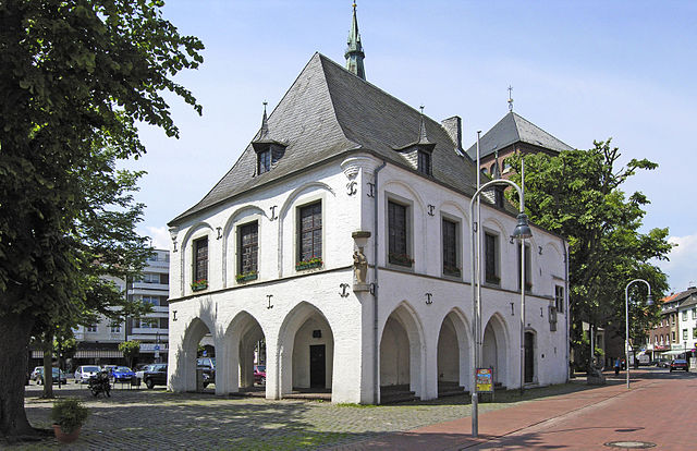
Hückelhoven
- town in the district Heinsberg, in North Rhine-Westphalia, Germany
Hiking in Hückelhoven
Hückelhoven is located in North Rhine-Westphalia, Germany, and is surrounded by scenic landscapes that offer some enjoyable hiking opportunities. While Hückelhoven itself is a small town, its proximity to natural areas makes it a good starting point for exploring the surrounding regions....
- Country:
- Postal Code: 41836
- Local Dialing Code: 02433
- Licence Plate Code: HS
- Coordinates: 51° 3' 39" N, 6° 13' 11" E
- GPS tracks (wikiloc): [Link]
- AboveSeaLevel: 75 м m
- Area: 61.27 sq km
- Population: 39585
- Web site: [Link]


Waldfeucht
- municipality of Germany
Hiking in Waldfeucht
Waldfeucht, a charming village situated in North Rhine-Westphalia, Germany, offers a variety of hiking opportunities through its picturesque landscapes, including forests, fields, and scenic views of the countryside. Here are some aspects to consider when hiking in Waldfeucht:...
- Country:
- Postal Code: 52525
- Local Dialing Code: 02455; 02452
- Coordinates: 51° 3' 58" N, 5° 59' 17" E
- GPS tracks (wikiloc): [Link]
- AboveSeaLevel: 50 м m
- Area: 30.27 sq km
- Population: 8745
- Web site: [Link]


Selfkant
- municipality of Germany
Hiking in Selfkant
Selfkant, a picturesque municipality in the state of North Rhine-Westphalia, Germany, offers a variety of hiking opportunities that allow visitors to explore its rich natural beauty and cultural heritage. Nestled near the borders with the Netherlands and Belgium, Selfkant is characterized by scenic landscapes, charming villages, and a backdrop of rolling hills....
- Country:
- Postal Code: 52538
- Local Dialing Code: 02456
- Licence Plate Code: HS
- Coordinates: 51° 1' 0" N, 5° 55' 0" E
- GPS tracks (wikiloc): [Link]
- AboveSeaLevel: 69 м m
- Area: 42.08 sq km
- Population: 10075
- Web site: [Link]


Gangelt
- municipality of Germany
Hiking in Gangelt
Gangelt, located in North Rhine-Westphalia, Germany, offers a scenic and serene environment for hiking enthusiasts. While it may not be as famous as some other hiking destinations in Germany, it boasts charming landscapes, lush fields, and surrounding woodlands that create an excellent backdrop for outdoor activities....
- Country:
- Postal Code: 52538
- Local Dialing Code: 02454
- Licence Plate Code: HS
- Coordinates: 50° 58' 59" N, 6° 0' 0" E
- GPS tracks (wikiloc): [Link]
- AboveSeaLevel: 60 м m
- Area: 48.73 sq km
- Population: 12383
- Web site: [Link]


Wegberg
- town in North Rhine-Westphalia, Germany
Hiking in Wegberg
Wegberg, a picturesque town in North Rhine-Westphalia, Germany, offers several opportunities for hiking enthusiasts. The region is characterized by its lush green landscapes, forests, and the scenic paths that wind through the countryside. Here are some key highlights for hiking in Wegberg:...
- Country:
- Postal Code: 41844
- Local Dialing Code: 02436; 02434; 02432; 02431; 02161
- Licence Plate Code: HS
- Coordinates: 51° 8' 0" N, 6° 16' 0" E
- GPS tracks (wikiloc): [Link]
- AboveSeaLevel: 61 м m
- Area: 84 sq km
- Population: 27921
- Web site: [Link]


Wassenberg
- municipality of Germany
Hiking in Wassenberg
Wassenberg, located in North Rhine-Westphalia, Germany, is not only celebrated for its historical charm but also for its scenic trails and natural beauty, making it a great destination for hiking enthusiasts....
- Country:
- Postal Code: 41849
- Local Dialing Code: 02432
- Coordinates: 51° 6' 0" N, 6° 9' 0" E
- GPS tracks (wikiloc): [Link]
- AboveSeaLevel: 50 м m
- Area: 42.41 sq km
- Population: 18143
- Web site: [Link]


Übach-Palenberg
- town in Germany
Hiking in Übach-Palenberg
Ubach-Palenberg, located in North Rhine-Westphalia, Germany, is not as widely known for hiking as some other regions, but it still offers some opportunities for outdoor enthusiasts. The area showcases beautiful landscapes, typical of the German countryside, with a mix of forests, fields, and small hills....
- Country:
- Postal Code: 52531
- Local Dialing Code: 02451
- Coordinates: 50° 55' 11" N, 6° 7' 10" E
- GPS tracks (wikiloc): [Link]
- AboveSeaLevel: 110 м m
- Area: 26.11 sq km
- Population: 24083
- Web site: [Link]


Geilenkirchen
- municipality of Germany
Hiking in Geilenkirchen
Geilenkirchen, located in the North Rhine-Westphalia region of Germany, is surrounded by beautiful landscapes that are perfect for hiking enthusiasts. Although it may not be as renowned as some larger hiking areas in Germany, it still offers a variety of trails that cater to different skill levels....
- Country:
- Postal Code: 52511
- Local Dialing Code: 02462; 02453; 02451
- Coordinates: 50° 57' 55" N, 6° 7' 10" E
- GPS tracks (wikiloc): [Link]
- AboveSeaLevel: 95 м m
- Area: 83 sq km
- Population: 27106
- Web site: [Link]

Erkelenz
- town in the Rhineland in western Germany
Hiking in Erkelenz
Erkelenz, located in North Rhine-Westphalia, Germany, is not widely known as a hiking destination, but it offers some pleasant trails and natural beauty for outdoor enthusiasts. Here are some key points about hiking in and around Erkelenz:...
- Country:
- Postal Code: 41812
- Local Dialing Code: 02433; 02435; 02432; 02164; 02431
- Coordinates: 51° 4' 48" N, 6° 18' 56" E
- GPS tracks (wikiloc): [Link]
- AboveSeaLevel: 92 м m
- Area: 117.35 sq km
- Population: 43392
- Web site: [Link]
Shares border with regions:


Viersen
- district in North Rhine-Westphalia, Germany
Hiking in Viersen
Viersen, located in North Rhine-Westphalia, Germany, is a charming district that offers a variety of outdoor activities, including hiking. The area is characterized by its scenic landscapes, lush forests, and well-maintained trails, making it a great destination for both novice and experienced hikers....
- Country:
- Licence Plate Code: VIE
- Coordinates: 51° 16' 12" N, 6° 24' 0" E
- GPS tracks (wikiloc): [Link]
- AboveSeaLevel: 92 м m
- Web site: [Link]
Rhein-Kreis Neuss
- district in North Rhine-Westphalia, Germany
Hiking in Rhein-Kreis Neuss
Rhein-Kreis Neuss, located in North Rhine-Westphalia, Germany, offers a variety of hiking opportunities that showcase its natural beauty and cultural heritage. The region is characterized by scenic landscapes, rolling hills, forests, and rivers, making it an ideal destination for hikers of all levels. Here are some key features and trails you might consider:...
- Country:
- Licence Plate Code: NE
- Coordinates: 51° 9' 55" N, 6° 39' 14" E
- GPS tracks (wikiloc): [Link]
- AboveSeaLevel: 48 м m
- Area: 576.52 sq km
- Web site: [Link]


Aachen cities region
- German district of North Rhine-Westphalia
Hiking in Aachen cities region
Aachen, located in western Germany, is surrounded by beautiful landscapes that are ideal for hiking enthusiasts. The district offers a variety of trails that cater to different skill levels, providing opportunities to explore both natural and historical sites. Here are some highlights and tips for hiking in the Aachen district:...
- Country:
- Capital: Aachen
- Licence Plate Code: MON; AC
- Coordinates: 50° 46' 7" N, 6° 5' 49" E
- GPS tracks (wikiloc): [Link]
- AboveSeaLevel: 168 м m
- Area: 707.15 sq km
- Population: 545067
- Web site: [Link]


Düren
- German district of North Rhine-Westphalia
Hiking in Düren
Düren district, located in North Rhine-Westphalia, Germany, offers a variety of hiking opportunities that cater to different skill levels and preferences. The region is characterized by its lush landscapes, rolling hills, and scenic views, making it an excellent destination for outdoor enthusiasts....
- Country:
- Licence Plate Code: DN
- Coordinates: 50° 49' 48" N, 6° 30' 0" E
- GPS tracks (wikiloc): [Link]
- AboveSeaLevel: 118 м m
- Web site: [Link]