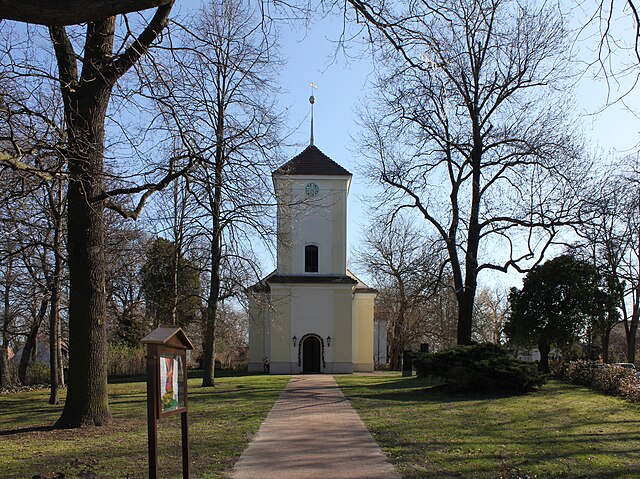
Hermsdorf (Hermsdorf)

- locality of Berlin
 Hiking in Hermsdorf
Hermsdorf is a charming district located in the northern part of Berlin, surrounded by lush green spaces and natural beauty, making it a great destination for hiking and outdoor activities. While it may not have extensive hiking trails like some larger nature reserves or national parks, there are still various routes and parks nearby that cater to hikers.
Nearby Hiking Areas
-
Tegel Forest (Tegeler Forst): Just a short distance from Hermsdorf, Tegel Forest offers numerous walking and hiking paths winding through dense woodlands. Trails range from easy to moderate difficulty, making it suitable for families and more experienced hikers alike.
-
Grunewald Forest: Located a bit further to the southwest, Grunewald is one of Berlin’s most popular outdoor areas. It features a variety of hiking trails, including paths leading to the famous Teufelsberg, which offers scenic views of the city.
-
Berlin’s Green Spaces: Hermsdorf itself has several parks and green areas such as the Volkspark Rehberge and local parks that are perfect for leisurely walks or short hikes. Exploring these areas can give you a taste of nature without venturing far from the city.
Hiking Tips
-
Prepare for Varied Terrain: While many of the trails are well-maintained, some areas might have uneven ground or roots. Sturdy hiking shoes are recommended.
-
Check Weather Conditions: As with any hike, be sure to check the weather forecast ahead of time. Berlin can have variable weather, and it's wise to dress in layers.
-
Stay Hydrated and Snack Ready: Bring enough water and some snacks to keep your energy up during your hike.
-
Follow Local Guidelines: Always respect nature and follow local guidelines regarding trails, especially in protected areas.
Accessibility
Hermsdorf is well-connected by public transport, making it easy to reach various hiking spots. You can use the U-Bahn or bus services to access larger forest parks and trails.
Conclusion
While Hermsdorf may not be a hiking hotspot per se, its proximity to larger natural areas like Tegel Forest and Grunewald makes it a suitable starting point for day hikes. With its scenic landscapes and tranquil surroundings, hikers can enjoy both short walks and longer trails in the vicinity.
- Country:

- Postal Code: 13467
- Coordinates: 52° 37' 0" N, 13° 19' 0" E


- GPS tracks (wikiloc): [Link]
- AboveSeaLevel: 37 м m
- Area: 6.1 sq km
- Population: 15440
- Wikipedia en: wiki(en)
- Wikipedia: wiki(de)
- Wikidata storage: Wikidata: Q565018
- Wikipedia Commons Gallery: [Link]
- Wikipedia Commons Category: [Link]
- Wikipedia Commons Maps Category: [Link]
- Freebase ID: [/m/0dc872]
- GeoNames ID: Alt: [2905904]
- VIAF ID: Alt: [149262448]
- GND ID: Alt: [4356299-1]
- archINFORM location ID: [43222]
- Library of Congress authority ID: Alt: [no2002068303]
Shares border with regions:
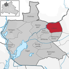
Lübars
- locality of Berlin
Hiking in Lübars
Lübars, located in the northern part of Berlin, Germany, is a charming district that offers beautiful green spaces and opportunities for hiking and outdoor activities. While it may not be as well-known as other hiking destinations, it provides a delightful escape into nature within the city....
- Country:
- Coordinates: 52° 37' 0" N, 13° 22' 0" E
- GPS tracks (wikiloc): [Link]
- AboveSeaLevel: 53 м m
- Area: 5 sq km
- Population: 4969


Frohnau
- locality of Berlin
Hiking in Frohnau
Frohnau is a district of the city of Annaberg-Buchholz in the Erzgebirge (Ore Mountains) region of Germany, known for its stunning natural landscapes and rich history. When hiking in Frohnau, you'll have the opportunity to explore beautiful trails, lush forests, and picturesque views....
- Country:
- Postal Code: 13465
- Coordinates: 52° 38' 0" N, 13° 18' 0" E
- GPS tracks (wikiloc): [Link]
- AboveSeaLevel: 55 м m
- Area: 7.8 sq km
- Population: 16782


Waidmannslust
- locality of Berlin
Hiking in Waidmannslust
Waidmannslust is a neighborhood located in the northeastern part of Berlin, Germany. While it is primarily a residential area and doesn’t have extensive hiking trails in the traditional sense, there are several nearby locations that offer green spaces and opportunities for walking and light hiking. Here are some options for exploring the area:...
- Country:
- Coordinates: 52° 36' 24" N, 13° 19' 15" E
- GPS tracks (wikiloc): [Link]
- AboveSeaLevel: 47 м m
- Area: 2.3 sq km