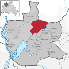
Lübars (Lübars)

- locality of Berlin
 Hiking in Lübars
Lübars, located in the northern part of Berlin, Germany, is a charming district that offers beautiful green spaces and opportunities for hiking and outdoor activities. While it may not be as well-known as other hiking destinations, it provides a delightful escape into nature within the city.
Hiking Trails and Routes
-
Lübars Forest:
- The area features dense forests and meadows, offering several trails suitable for hiking. The shaded paths in Lübars Forest can provide a pleasant experience, especially during warmer months.
-
Tegeler Fließ:
- Nearby is the Tegeler Fließ area, a natural reserve with many walking and hiking routes through wetlands and along streams. This region is great for those who want to immerse themselves in nature while observing local wildlife.
-
Berlin Wall Trail:
- Some routes in Lübars connect with the Berlin Wall Trail, where you can hike along the historic remnants of the Berlin Wall, combining history with nature.
Scenic Spots
- Lübars Farm: This working farm allows visitors to take a break and enjoy some local produce. It's a great spot to rest before continuing your hike.
- Hiking through Parks: Lübars is surrounded by various parks that are ideal for short hikes or leisurely walks, allowing for scenic views and picnicking opportunities.
Accessibility
Lübars is accessible via public transport, making it easy to reach for a day of hiking. The area is relatively flat, making it suitable for hikers of all experience levels, including families with children.
Tips for Hiking in Lübars
- Dress Appropriately: Wear comfortable hiking shoes and dress in layers, as the weather can change quickly.
- Stay Hydrated: Bring plenty of water, especially during longer hikes.
- Respect Nature: Follow local guidelines to preserve the natural environment, such as sticking to marked trails and taking your litter with you.
- Wildlife Awareness: Be mindful of the local wildlife, and maintain a safe distance.
Overall, while Lübars may not be a mountainous hiking destination, it offers a serene and picturesque environment for nature walks and light hiking in an urban setting. Enjoy your hike!
- Country:

- Coordinates: 52° 37' 0" N, 13° 22' 0" E


- GPS tracks (wikiloc): [Link]
- AboveSeaLevel: 53 м m
- Area: 5 sq km
- Population: 4969
- Wikipedia en: wiki(en)
- Wikipedia: wiki(de)
- Wikidata storage: Wikidata: Q563664
- Wikipedia Commons Gallery: [Link]
- Wikipedia Commons Category: [Link]
- Freebase ID: [/m/0bwkr4r]
- GeoNames ID: Alt: [2875631]
- VIAF ID: Alt: [131004812]
- GND ID: Alt: [4479855-6]
- archINFORM location ID: [43351]
- Library of Congress authority ID: Alt: [n2006053744]
Shares border with regions:

Hermsdorf
- locality of Berlin
Hiking in Hermsdorf
Hermsdorf is a charming district located in the northern part of Berlin, surrounded by lush green spaces and natural beauty, making it a great destination for hiking and outdoor activities. While it may not have extensive hiking trails like some larger nature reserves or national parks, there are still various routes and parks nearby that cater to hikers....
- Country:
- Postal Code: 13467
- Coordinates: 52° 37' 0" N, 13° 19' 0" E
- GPS tracks (wikiloc): [Link]
- AboveSeaLevel: 37 м m
- Area: 6.1 sq km
- Population: 15440


Waidmannslust
- locality of Berlin
Hiking in Waidmannslust
Waidmannslust is a neighborhood located in the northeastern part of Berlin, Germany. While it is primarily a residential area and doesn’t have extensive hiking trails in the traditional sense, there are several nearby locations that offer green spaces and opportunities for walking and light hiking. Here are some options for exploring the area:...
- Country:
- Coordinates: 52° 36' 24" N, 13° 19' 15" E
- GPS tracks (wikiloc): [Link]
- AboveSeaLevel: 47 м m
- Area: 2.3 sq km
Blankenfelde
- locality of Berlin
Hiking in Blankenfelde
Blankenfelde, located in the state of Brandenburg, Germany, offers a variety of hiking opportunities amidst its picturesque landscapes, including forests, fields, and small lakes. Here are some highlights of hiking in the area:...
- Country:
- Coordinates: 52° 37' 7" N, 13° 23' 26" E
- GPS tracks (wikiloc): [Link]
- AboveSeaLevel: 53 м m
- Area: 13.4 sq km