Huisseau-sur-Mauves (Huisseau-sur-Mauves)

- commune in Loiret, France
- Country:

- Postal Code: 45130
- Coordinates: 47° 53' 35" N, 1° 42' 11" E


- GPS tracks (wikiloc): [Link]
- Area: 37.16 sq km
- Population: 1672
- Web site: http://www.huisseausurmauves.fr
- Wikipedia en: wiki(en)
- Wikipedia: wiki(fr)
- Wikidata storage: Wikidata: Q978725
- Wikipedia Commons Category: [Link]
- Freebase ID: [/m/03nwgy7]
- GeoNames ID: Alt: [6434617]
- SIREN number: [214501678]
- BnF ID: [15260559g]
- VIAF ID: Alt: [234293169]
- PACTOLS thesaurus ID: [pcrtwMTVqzb894]
- SUDOC authorities ID: [180923706]
- INSEE municipality code: 45167
Shares border with regions:

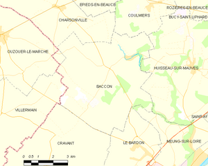
Baccon
- commune in Loiret, France
- Country:
- Postal Code: 45130
- Coordinates: 47° 53' 28" N, 1° 37' 43" E
- GPS tracks (wikiloc): [Link]
- Area: 33.02 sq km
- Population: 706


Chaingy
- commune in Loiret, France
- Country:
- Postal Code: 45380
- Coordinates: 47° 53' 1" N, 1° 46' 23" E
- GPS tracks (wikiloc): [Link]
- Area: 21.69 sq km
- Population: 3617
- Web site: [Link]

Coulmiers
- commune in Loiret, France
- Country:
- Postal Code: 45130
- Coordinates: 47° 55' 53" N, 1° 39' 49" E
- GPS tracks (wikiloc): [Link]
- Area: 14.28 sq km
- Population: 552
- Web site: [Link]


Saint-Ay
- commune in Loiret, France
- Country:
- Postal Code: 45130
- Coordinates: 47° 51' 29" N, 1° 45' 14" E
- GPS tracks (wikiloc): [Link]
- Area: 10.07 sq km
- Population: 3317
- Web site: [Link]


Rozières-en-Beauce
- commune in Loiret, France
- Country:
- Postal Code: 45130
- Coordinates: 47° 56' 31" N, 1° 42' 6" E
- GPS tracks (wikiloc): [Link]
- Area: 9.17 sq km
- Population: 205


Bucy-Saint-Liphard
- commune in Loiret, France
- Country:
- Postal Code: 45140
- Coordinates: 47° 56' 9" N, 1° 45' 54" E
- GPS tracks (wikiloc): [Link]
- Area: 17.84 sq km
- Population: 200


Meung-sur-Loire
- commune in Loiret, France
- Country:
- Postal Code: 45130
- Coordinates: 47° 49' 43" N, 1° 41' 54" E
- GPS tracks (wikiloc): [Link]
- Area: 20.35 sq km
- Population: 6267
- Web site: [Link]