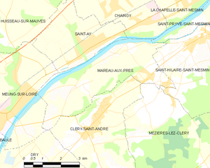
Meung-sur-Loire (Meung-sur-Loire)

- commune in Loiret, France
- Country:

- Postal Code: 45130
- Coordinates: 47° 49' 43" N, 1° 41' 54" E


- GPS tracks (wikiloc): [Link]
- Area: 20.35 sq km
- Population: 6267
- Web site: http://www.ville-meung-sur-loire.fr
- Wikipedia en: wiki(en)
- Wikipedia: wiki(fr)
- Wikidata storage: Wikidata: Q658776
- Wikipedia Commons Category: [Link]
- Freebase ID: [/m/07y1v_]
- GeoNames ID: Alt: [2994126]
- SIREN number: [214502031]
- BnF ID: [15260595b]
- VIAF ID: Alt: [137970101]
- GND ID: Alt: [4302562-6]
- Library of Congress authority ID: Alt: [no2017005202]
- PACTOLS thesaurus ID: [pcrtHxwct3UyJe]
- MusicBrainz area ID: [5f6558ed-7e73-4961-a7ea-f42bf1862279]
- EMLO location ID: [536facfd-dfe5-4d8e-94f7-120e48f87108]
- INSEE municipality code: 45203
Shares border with regions:


Le Bardon
- commune in Loiret, France
- Country:
- Postal Code: 45130
- Coordinates: 47° 50' 39" N, 1° 39' 5" E
- GPS tracks (wikiloc): [Link]
- Area: 12.23 sq km
- Population: 1060

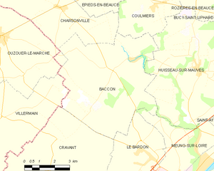
Baccon
- commune in Loiret, France
- Country:
- Postal Code: 45130
- Coordinates: 47° 53' 28" N, 1° 37' 43" E
- GPS tracks (wikiloc): [Link]
- Area: 33.02 sq km
- Population: 706

Baule
- commune in Loiret, France
- Country:
- Postal Code: 45130
- Coordinates: 47° 48' 39" N, 1° 40' 15" E
- GPS tracks (wikiloc): [Link]
- Area: 12.11 sq km
- Population: 2072
- Web site: [Link]


Saint-Ay
- commune in Loiret, France
- Country:
- Postal Code: 45130
- Coordinates: 47° 51' 29" N, 1° 45' 14" E
- GPS tracks (wikiloc): [Link]
- Area: 10.07 sq km
- Population: 3317
- Web site: [Link]


Dry
- commune in Loiret, France
- Country:
- Postal Code: 45370
- Coordinates: 47° 47' 48" N, 1° 42' 50" E
- GPS tracks (wikiloc): [Link]
- Area: 22.64 sq km
- Population: 1398
Mareau-aux-Prés
- commune in Loiret, France
- Country:
- Postal Code: 45370
- Coordinates: 47° 50' 50" N, 1° 47' 58" E
- GPS tracks (wikiloc): [Link]
- Area: 13.34 sq km
- Population: 1250
- Web site: [Link]


Huisseau-sur-Mauves
- commune in Loiret, France
- Country:
- Postal Code: 45130
- Coordinates: 47° 53' 35" N, 1° 42' 11" E
- GPS tracks (wikiloc): [Link]
- Area: 37.16 sq km
- Population: 1672
- Web site: [Link]