
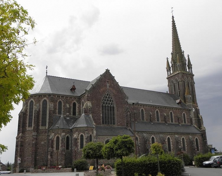
Iffendic (Iffendic)

- commune in Ille-et-Vilaine, France
- Country:

- Postal Code: 35750
- Coordinates: 48° 7' 47" N, 2° 2' 5" E


- GPS tracks (wikiloc): [Link]
- Area: 73.66 sq km
- Population: 4456
- Web site: http://www.iffendic.com
- Wikipedia en: wiki(en)
- Wikipedia: wiki(fr)
- Wikidata storage: Wikidata: Q533891
- Wikipedia Commons Category: [Link]
- Freebase ID: [/m/03h3d_y]
- Freebase ID: [/m/03h3d_y]
- GeoNames ID: Alt: [3012905]
- GeoNames ID: Alt: [3012905]
- SIREN number: [213501331]
- SIREN number: [213501331]
- BnF ID: [15257077h]
- BnF ID: [15257077h]
- OSM relation ID: [149719]
- OSM relation ID: [149719]
- PACTOLS thesaurus ID: [pcrtvXmghZ1ylA]
- PACTOLS thesaurus ID: [pcrtvXmghZ1ylA]
- MusicBrainz area ID: [fb015441-33aa-4c09-b16e-511e0b96dfbf]
- MusicBrainz area ID: [fb015441-33aa-4c09-b16e-511e0b96dfbf]
- INSEE municipality code: 35133
- INSEE municipality code: 35133
Shares border with regions:


Saint-Malon-sur-Mel
- commune in Ille-et-Vilaine, France
- Country:
- Postal Code: 35750
- Coordinates: 48° 5' 35" N, 2° 5' 56" E
- GPS tracks (wikiloc): [Link]
- AboveSeaLevel: 96 м m
- Area: 16.07 sq km
- Population: 591
- Web site: [Link]


Paimpont
- commune in Ille-et-Vilaine, France
- Country:
- Postal Code: 35380
- Coordinates: 48° 1' 5" N, 2° 10' 16" E
- GPS tracks (wikiloc): [Link]
- Area: 110.28 sq km
- Population: 1672
- Web site: [Link]


Montauban-de-Bretagne
- commune in Ille-et-Vilaine, France
- Country:
- Postal Code: 35360
- Coordinates: 48° 11' 57" N, 2° 2' 53" E
- GPS tracks (wikiloc): [Link]
- Area: 45.42 sq km
- Population: 5747
- Web site: [Link]


Saint-Maugan
- commune in Ille-et-Vilaine, France
- Country:
- Postal Code: 35750
- Coordinates: 48° 8' 6" N, 2° 5' 1" E
- GPS tracks (wikiloc): [Link]
- Area: 8.43 sq km
- Population: 559


Saint-Péran
- commune in Ille-et-Vilaine, France
- Country:
- Postal Code: 35380
- Coordinates: 48° 3' 18" N, 2° 3' 22" E
- GPS tracks (wikiloc): [Link]
- Area: 9.37 sq km
- Population: 401
- Web site: [Link]


Saint-Uniac
- commune in Ille-et-Vilaine, France
- Country:
- Postal Code: 35360
- Coordinates: 48° 10' 23" N, 2° 1' 43" E
- GPS tracks (wikiloc): [Link]
- Area: 6.89 sq km
- Population: 527

Bédée
- commune in Ille-et-Vilaine, France
- Country:
- Postal Code: 35137
- Coordinates: 48° 10' 46" N, 1° 56' 39" E
- GPS tracks (wikiloc): [Link]
- Area: 38.95 sq km
- Population: 4200
- Web site: [Link]

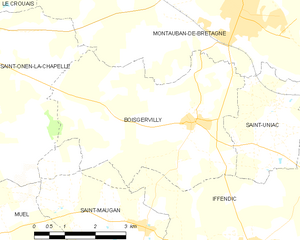
Boisgervilly
- commune in Ille-et-Vilaine, France
- Country:
- Postal Code: 35360
- Coordinates: 48° 10' 1" N, 2° 3' 50" E
- GPS tracks (wikiloc): [Link]
- Area: 19.95 sq km
- Population: 1625


La Nouaye
- commune in Ille-et-Vilaine, France
- Country:
- Postal Code: 35137
- Coordinates: 48° 9' 45" N, 1° 58' 45" E
- GPS tracks (wikiloc): [Link]
- Area: 2.77 sq km
- Population: 366


Saint-Onen-la-Chapelle
- commune in Ille-et-Vilaine, France
- Country:
- Postal Code: 35290
- Coordinates: 48° 10' 37" N, 2° 10' 22" E
- GPS tracks (wikiloc): [Link]
- Area: 24.66 sq km
- Population: 1191
- Web site: [Link]

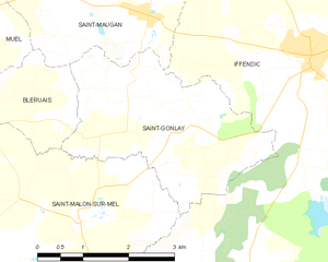
Saint-Gonlay
- commune in Ille-et-Vilaine, France
- Country:
- Postal Code: 35750
- Coordinates: 48° 6' 47" N, 2° 3' 57" E
- GPS tracks (wikiloc): [Link]
- Area: 9.26 sq km
- Population: 341


Monterfil
- commune in Ille-et-Vilaine, France
- Country:
- Postal Code: 35160
- Coordinates: 48° 3' 57" N, 1° 58' 43" E
- GPS tracks (wikiloc): [Link]
- Area: 16.94 sq km
- Population: 1305
- Web site: [Link]

Talensac
- commune in Ille-et-Vilaine, France
- Country:
- Postal Code: 35160
- Coordinates: 48° 6' 30" N, 1° 55' 42" E
- GPS tracks (wikiloc): [Link]
- Area: 21.61 sq km
- Population: 2486
- Web site: [Link]


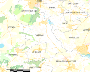
Montfort-sur-Meu
- commune in Ille-et-Vilaine, France
- Country:
- Postal Code: 35160
- Coordinates: 48° 8' 17" N, 1° 57' 21" E
- GPS tracks (wikiloc): [Link]
- Area: 14.02 sq km
- Population: 6556
- Web site: [Link]