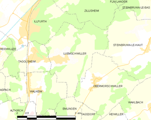
Illfurth (Illfurth)

- commune in Haut-Rhin, France
 Hiking in Illfurth
Illfurth is a picturesque village located in the Alsace region of France, near the border with Germany. While it may not be as widely known as some other hiking destinations, it offers access to serene landscapes and scenic trails that are perfect for nature lovers and hiking enthusiasts.
Hiking Opportunities in Illfurth
-
Local Trails: The area surrounding Illfurth has a network of local trails that can take you through charming countryside, rolling hills, and woodlands. These trails are often marked and vary in difficulty, making them suitable for different skill levels.
-
Nearby Nature Reserves: The nearby Parc Naturel Régional des Ballons des Vosges and other natural reserves offer more extensive hiking options. You can explore various terrains, including forests, slopes, and panoramic views of the Vosges Mountains.
-
Historical and Cultural Sites: Hiking in this region often allows you to explore local cultural and historical sites, including traditional Alsatian architecture and small villages, enhancing the hiking experience with a glimpse into the local heritage.
-
Scenic Views: Many trails in the region reward hikers with stunning views of the countryside and Alsace’s vineyards. Be sure to bring your camera!
-
Wildlife and Flora: As you hike in and around Illfurth, you may encounter a variety of wildlife and unique plant species native to the region, especially if you explore less trafficked paths.
Tips for Hiking in Illfurth
- Check Trail Maps: Before heading out, ensure you have a good map or download a hiking app that helps you navigate the trails in the area.
- Seasonal Considerations: The best times for hiking in Illfurth are typically spring and fall when the weather is mild and the scenery is breathtaking. Summer can also be enjoyable, but it may be hotter and busier.
- Gear Up Properly: Wear appropriate hiking shoes and clothing suited for the weather conditions. Always bring water, snacks, and a first-aid kit for safety.
- Respect Nature: Follow Leave No Trace principles to help preserve the natural beauty of the area for future hikers.
Conclusion
Hiking in Illfurth offers a wonderful opportunity to explore the natural beauty and charm of the Alsatian countryside. Whether you're a seasoned hiker or just looking for a pleasant walk, the area has something to offer for everyone. Enjoy your outdoor adventure!
- Country:

- Postal Code: 68720
- Coordinates: 47° 40' 21" N, 7° 15' 54" E


- GPS tracks (wikiloc): [Link]
- Area: 9.16 sq km
- Population: 2486
- Web site: http://www.illfurth.fr
- Wikipedia en: wiki(en)
- Wikipedia: wiki(fr)
- Wikidata storage: Wikidata: Q83413
- Wikipedia Commons Category: [Link]
- Freebase ID: [/m/03nsszk]
- Freebase ID: [/m/03nsszk]
- GeoNames ID: Alt: [6441482]
- GeoNames ID: Alt: [6441482]
- SIREN number: [216801522]
- SIREN number: [216801522]
- BnF ID: [152718541]
- BnF ID: [152718541]
- VIAF ID: Alt: [243890433]
- VIAF ID: Alt: [243890433]
- PACTOLS thesaurus ID: [pcrtDsSnRugEbc]
- PACTOLS thesaurus ID: [pcrtDsSnRugEbc]
- INSEE municipality code: 68152
- INSEE municipality code: 68152
Shares border with regions:

Luemschwiller
- commune in Haut-Rhin, France
Hiking in Luemschwiller
Luemschwiller is a picturesque village located in the Alsace region of France, close to the border with Switzerland. This area is known for its charming landscapes, gentle hills, and scenic views, making it an attractive destination for hiking enthusiasts....
- Country:
- Postal Code: 68720
- Coordinates: 47° 39' 19" N, 7° 17' 21" E
- GPS tracks (wikiloc): [Link]
- Area: 7.27 sq km
- Population: 768


Zillisheim
- commune in Haut-Rhin, France
Hiking in Zillisheim
Zillisheim is a quaint village located in the Alsace region of France, not far from the city of Mulhouse. The area is characterized by its beautiful landscapes, rolling hills, and scenic views, making it a great destination for hiking enthusiasts....
- Country:
- Postal Code: 68720
- Coordinates: 47° 41' 43" N, 7° 17' 44" E
- GPS tracks (wikiloc): [Link]
- Area: 8.22 sq km
- Population: 2607


Spechbach
- commune in Haut-Rhin, France
Hiking in Spechbach
Spechbach, situated in the Haut-Rhin department of Alsace, France, offers a serene and picturesque setting for hiking enthusiasts. The region is characterized by its lush landscapes, rolling hills, and proximity to the Vosges Mountains, making it an excellent destination for outdoor activities....
- Country:
- Postal Code: 68720
- Coordinates: 47° 40' 16" N, 7° 13' 45" E
- GPS tracks (wikiloc): [Link]
- Area: 8.06 sq km


Heidwiller
- commune in Haut-Rhin, France
Hiking in Heidwiller
Heidwiller is a small commune located in the Alsace region of France, near the border with Switzerland. While it may not be a widely recognized hiking destination compared to larger national parks or mountainous areas, there are still opportunities for hiking enthusiasts to explore the surrounding countryside and enjoy the natural beauty of the region....
- Country:
- Postal Code: 68720
- Coordinates: 47° 39' 40" N, 7° 14' 38" E
- GPS tracks (wikiloc): [Link]
- Area: 4.48 sq km
- Population: 591


Hochstatt
- commune in Haut-Rhin, France
Hiking in Hochstatt
Hochstatt is a small town in Germany that may not be widely known for its hiking trails, but the surrounding regions offer some beautiful landscapes and outdoor opportunities. While the immediate area may have limited dedicated hiking paths, there are several nearby locations that are worth exploring for hiking enthusiasts....
- Country:
- Postal Code: 68720
- Coordinates: 47° 42' 7" N, 7° 16' 33" E
- GPS tracks (wikiloc): [Link]
- Area: 8.55 sq km
- Population: 2095


Galfingue
- commune in Haut-Rhin, France
Hiking in Galfingue
Galfingue is a small commune in the Haut-Rhin department in the Alsace region of France, located near the city of Mulhouse. While it might not be as widely known for hiking as some other regions in France, it offers opportunities for outdoor activities and exploration....
- Country:
- Postal Code: 68990
- Coordinates: 47° 42' 19" N, 7° 13' 27" E
- GPS tracks (wikiloc): [Link]
- Area: 5.36 sq km
- Population: 804


Frœningen
- commune in Haut-Rhin, France
Hiking in Frœningen
Frœningen is a picturesque location in the Swiss Alps, known for its stunning landscapes and diverse hiking opportunities. It is situated near the charming village of Frœningen, which serves as a great base for outdoor enthusiasts. When hiking in this area, you can expect beautiful mountain vistas, lush meadows, and clear alpine lakes....
- Country:
- Postal Code: 68720
- Coordinates: 47° 41' 27" N, 7° 16' 11" E
- GPS tracks (wikiloc): [Link]
- Area: 4.44 sq km
- Population: 695


Spechbach-le-Bas
- former commune in Haut-Rhin, France
Hiking in Spechbach-le-Bas
Spechbach-le-Bas is a charming village located in the Alsace region of France, close to the Vosges Mountains, which provides a beautiful backdrop for hiking enthusiasts. The area is known for its picturesque landscapes, diverse flora and fauna, and well-marked trails that cater to various skill levels....
- Country:
- Postal Code: 68720
- Coordinates: 47° 40' 13" N, 7° 13' 42" E
- GPS tracks (wikiloc): [Link]
- Area: 4.14 sq km
- Population: 677
Spechbach-le-Haut
- former commune in Haut-Rhin, France
Hiking in Spechbach-le-Haut
Spechbach-le-Haut is a charming commune located in the Alsace region of France. While not as widely known as some of the major hiking destinations in the area, it offers access to beautiful landscapes and hiking opportunities that can be enjoyed by both beginners and experienced hikers....
- Country:
- Postal Code: 68720
- Coordinates: 47° 40' 50" N, 7° 13' 0" E
- GPS tracks (wikiloc): [Link]
- Area: 3.92 sq km
- Population: 634


Tagolsheim
- commune in Haut-Rhin, France
Hiking in Tagolsheim
Tagolsheim is a small village located in the Alsace region of France, near the border with Germany. While it may not be as widely known as some hiking destinations, it is surrounded by beautiful countryside that offers opportunities for scenic walks and hiking....
- Country:
- Postal Code: 68720
- Coordinates: 47° 39' 20" N, 7° 16' 13" E
- GPS tracks (wikiloc): [Link]
- Area: 3.19 sq km
- Population: 871