Ingrandes (Ingrandes)

- commune in Indre, France
- Country:

- Postal Code: 36300
- Coordinates: 46° 35' 51" N, 0° 57' 48" E


- GPS tracks (wikiloc): [Link]
- Area: 11.12 sq km
- Population: 322
- Wikipedia en: wiki(en)
- Wikipedia: wiki(fr)
- Wikidata storage: Wikidata: Q1137609
- Wikipedia Commons Category: [Link]
- Freebase ID: [/m/03nv9kd]
- GeoNames ID: Alt: [6455075]
- SIREN number: [213600877]
- BnF ID: [15257391w]
- VIAF ID: Alt: [245385745]
- Digital Atlas of the Roman Empire ID: [7968]
- INSEE municipality code: 36087
Shares border with regions:


Concremiers
- commune in Indre, France
- Country:
- Postal Code: 36300
- Coordinates: 46° 35' 49" N, 1° 1' 0" E
- GPS tracks (wikiloc): [Link]
- Area: 28.11 sq km
- Population: 651


Saint-Aigny
- commune in Indre, France
- Country:
- Postal Code: 36300
- Coordinates: 46° 38' 45" N, 1° 1' 31" E
- GPS tracks (wikiloc): [Link]
- Area: 14.86 sq km
- Population: 290


Béthines
- commune in Vienne, France
- Country:
- Postal Code: 86310
- Coordinates: 46° 32' 49" N, 0° 58' 33" E
- GPS tracks (wikiloc): [Link]
- Area: 37.02 sq km
- Population: 475

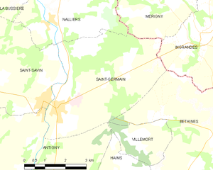
Saint-Germain
- commune in Vienne, France
- Country:
- Postal Code: 86310
- Coordinates: 46° 33' 49" N, 0° 52' 26" E
- GPS tracks (wikiloc): [Link]
- Area: 20.23 sq km
- Population: 941

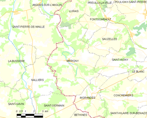
Mérigny
- commune in Indre, France
- Country:
- Postal Code: 36220
- Coordinates: 46° 37' 52" N, 0° 55' 33" E
- GPS tracks (wikiloc): [Link]
- Area: 31.77 sq km
- Population: 533
- Web site: [Link]