Mérigny (Mérigny)

- commune in Indre, France
- Country:

- Postal Code: 36220
- Coordinates: 46° 37' 52" N, 0° 55' 33" E


- GPS tracks (wikiloc): [Link]
- Area: 31.77 sq km
- Population: 533
- Web site: http://pagesperso-orange.fr/merigny/
- Wikipedia en: wiki(en)
- Wikipedia: wiki(fr)
- Wikidata storage: Wikidata: Q522062
- Wikipedia Commons Category: [Link]
- Freebase ID: [/m/03nvbxq]
- GeoNames ID: Alt: [2994384]
- SIREN number: [213601198]
- BnF ID: [15257423p]
- VIAF ID: Alt: [140885300]
- Library of Congress authority ID: Alt: [n96015631]
- EMLO location ID: [183e1b87-855e-4242-931b-5c15959d6502]
- INSEE municipality code: 36119
Shares border with regions:


Sauzelles
- commune in Indre, France
- Country:
- Postal Code: 36220
- Coordinates: 46° 39' 51" N, 1° 0' 9" E
- GPS tracks (wikiloc): [Link]
- Area: 12.86 sq km
- Population: 241


Saint-Aigny
- commune in Indre, France
- Country:
- Postal Code: 36300
- Coordinates: 46° 38' 45" N, 1° 1' 31" E
- GPS tracks (wikiloc): [Link]
- Area: 14.86 sq km
- Population: 290


Lurais
- commune in Indre, France
- Country:
- Postal Code: 36220
- Coordinates: 46° 42' 16" N, 0° 57' 2" E
- GPS tracks (wikiloc): [Link]
- Area: 13.61 sq km
- Population: 247
- Web site: [Link]

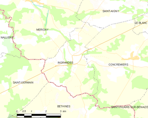
Ingrandes
- commune in Indre, France
- Country:
- Postal Code: 36300
- Coordinates: 46° 35' 51" N, 0° 57' 48" E
- GPS tracks (wikiloc): [Link]
- Area: 11.12 sq km
- Population: 322


Saint-Pierre-de-Maillé
- commune in Vienne, France
- Country:
- Postal Code: 86260
- Coordinates: 46° 40' 44" N, 0° 50' 37" E
- GPS tracks (wikiloc): [Link]
- Area: 74.89 sq km
- Population: 883

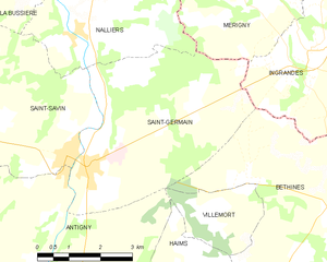
Saint-Germain
- commune in Vienne, France
- Country:
- Postal Code: 86310
- Coordinates: 46° 33' 49" N, 0° 52' 26" E
- GPS tracks (wikiloc): [Link]
- Area: 20.23 sq km
- Population: 941
Nalliers
- commune in Vienne, France
- Country:
- Postal Code: 86310
- Coordinates: 46° 36' 7" N, 0° 51' 59" E
- GPS tracks (wikiloc): [Link]
- Area: 16.03 sq km
- Population: 315

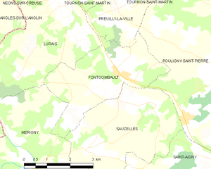
Fontgombault
- commune in Indre, France
- Country:
- Postal Code: 36220
- Coordinates: 46° 40' 27" N, 0° 59' 6" E
- GPS tracks (wikiloc): [Link]
- Area: 10.58 sq km
- Population: 247
- Web site: [Link]