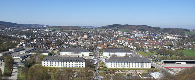
Iserlohn (Iserlohn)
- German city in the Märkischer Kreis district of North Rhine-Westphalia
Iserlohn is a picturesque town located in North Rhine-Westphalia, Germany, and offers a variety of excellent hiking opportunities for outdoor enthusiasts. The surrounding landscape is characterized by beautiful forests, hills, and the scenic Lenne River, making it an inviting destination for hiking.
Key Hiking Areas and Trails:
-
Hagen Hills (Hagener Bergland): Just south of Iserlohn, this area offers diverse trails with varying levels of difficulty. The region is known for its lush landscapes and panoramic views, making it a great choice for day hikes.
-
Lake Hohenheide (Hohenheider See): A popular area for both hiking and walking, the trails around this picturesque lake provide a relaxing environment, perfect for casual strolls or longer hikes.
-
Lenne Valley (Lenne-Tal): The paths along the Lenne River allow for gentle hikes that are suitable for families. The trails are often lined with beautiful vegetation and offer opportunities for birdwatching.
-
Schmalegger Forest (Schmalegger Wald): This forested area features well-marked trails that are excellent for those seeking a more rugged hiking experience. The tranquility of the forest can be a refreshing escape.
-
The Sauerland Region: Just a short distance from Iserlohn, the Sauerland offers a vast network of hiking trails. The Sauerland Höhenflug Trail is one of the most prominent, providing stunning views and a more adventurous hiking experience.
Tips for Hiking in Iserlohn:
- Trail Maps: It’s advisable to have a detailed map or a GPS app on your phone, as some trails might not be well-marked.
- Weather: Be aware of the weather conditions before you head out, as they can change rapidly, especially in forested areas.
- Footwear: Wear sturdy, comfortable hiking shoes or boots, as some trails can be uneven or muddy.
- Leave No Trace: Respect nature by following Leave No Trace principles—take your waste with you and avoid disturbing wildlife.
- Local Regulations: Always check for any local regulations or permits that may be required for specific trails or areas.
With its beautiful landscapes and well-maintained trails, Iserlohn is a fantastic destination for hikers of all levels, whether you're looking for a leisurely walk or a more challenging trek.
- Country:

- Postal Code: 58636–58644
- Local Dialing Code: 02371
- Licence Plate Code: MK
- Coordinates: 51° 23' 0" N, 7° 40' 0" E


- GPS tracks (wikiloc): [Link]
- AboveSeaLevel: 253 м m
- Area: 125.49 sq km
- Population: 92928
- Web site: https://www.iserlohn.de/
- Wikipedia en: wiki(en)
- Wikipedia: wiki(de)
- Wikidata storage: Wikidata: Q1130
- Wikipedia Commons Gallery: [Link]
- Wikipedia Commons Category: [Link]
- Wikipedia Commons Maps Category: [Link]
- Freebase ID: [/m/018z3k]
- GeoNames ID: Alt: [2895669]
- VIAF ID: Alt: [246048901]
- OSM relation ID: [1800165]
- GND ID: Alt: [4027734-3]
- archINFORM location ID: [5491]
- Library of Congress authority ID: Alt: [n80040323]
- MusicBrainz area ID: [443f1ab1-cbf2-4ec9-81de-e7ecb1e8dc83]
- Encyclopædia Britannica Online ID: [place/Iserlohn]
- Facebook Places ID: [111985898827147]
- National Library of Israel ID: [000978941]
- BabelNet ID: [01067040n]
- German municipality key: 05962024
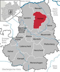
Shares border with regions:


Hemer
- German town in the Märkischer Kreis district of North Rhine-Westphalia
Hemer, located in the North Rhine-Westphalia region of Germany, offers several beautiful hiking opportunities that showcase its natural landscapes and scenic views. Here are some highlights and tips for hiking in this area:...
- Country:

- Postal Code: 58675; 5870
- Local Dialing Code: 02372
- Licence Plate Code: MK
- Coordinates: 51° 23' 0" N, 7° 46' 0" E


- GPS tracks (wikiloc): [Link]
- AboveSeaLevel: 546 м m
- Area: 67.66 sq km
- Population: 33535
- Web site: [Link]

