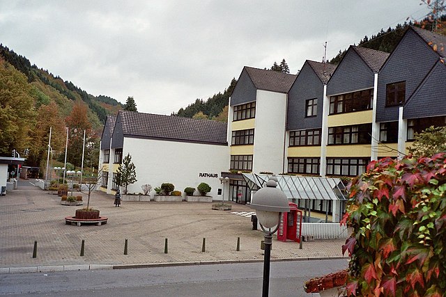
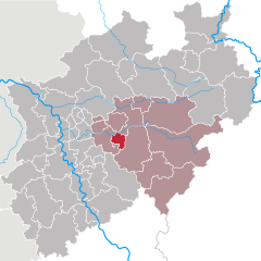
Märkischer Kreis (Märkischer Kreis)


- district in central North Rhine-Westphalia, Germany
 Hiking in Märkischer Kreis
Märkischer Kreis, located in North Rhine-Westphalia, Germany, is a beautiful region for hiking enthusiasts. It offers a blend of natural landscapes, charming small towns, and cultural heritage. Here are some highlights and things to know about hiking in this area:
Trails and Nature
-
Diverse Hiking Paths: The Märkischer Kreis boasts a variety of trails ranging from easy walks to more strenuous hikes. Many paths offer scenic views of the rolling hills, forests, and rivers characteristic of the region.
-
Nature Parks: The area includes parts of the Sauerland region, known for its rich biodiversity, with lush forests and diverse wildlife. The Sauerland-Rothaargebirge Nature Park is nearby and offers extensive hiking routes.
-
Hiking Regions:
- The Lenne Valley: Known for its picturesque landscape, the Lenne River runs through this area, providing beautiful river valley views.
- The Sauerland Ridgeway: This long-distance hiking trail connects various towns through stunning landscapes and is well-marked.
Historical and Cultural Sites
-
Ruins and Castles: Along the hiking routes, you might encounter historical ruins and castles, such as the ruins of the Altena Castle, which add a cultural depth to your outdoor experience.
-
Local Villages: The quaint towns, like Altena, Lüdenscheid, and Iserlohn, offer a glimpse into the region’s history and culture, with opportunities to rest and enjoy local cuisine.
Practical Information
-
Trail Marking: Most trails are well-marked with signs and maps available at tourist information centers or online. It's advisable to carry a physical map or download a hiking app for navigation.
-
Weather Considerations: The weather can change quickly, so it's essential to check forecasts before setting out. Be prepared for rain and varying temperatures, especially in the spring and autumn.
-
Safety: Always let someone know your hiking plans, especially if you're going on remote trails. Carry enough water, snacks, and a first-aid kit.
-
Respect Nature: Follow the Leave No Trace principles to preserve the natural beauty and wildlife of the area.
Best Time to Hike
Spring (April to June) and autumn (September to October) are particularly nice for hiking, with mild temperatures and fewer crowds. Summer can be warm but is also a fantastic time to explore, while winter hiking offers a unique beauty, especially in snowy conditions.
Overall, hiking in Märkischer Kreis can be a fulfilling experience, combining physical activity with the opportunity to immerse yourself in nature and local culture. Enjoy your adventure!
- Country:

- Capital: Lüdenscheid
- Licence Plate Code: MK
- Coordinates: 51° 13' 30" N, 7° 36' 52" E


- GPS tracks (wikiloc): [Link]
- AboveSeaLevel: 186 м m
- Area: 1058.95 sq km
- Population: 416171
- Web site: http://www.maerkischer-kreis.de
- Wikipedia en: wiki(en)
- Wikipedia: wiki(de)
- Wikidata storage: Wikidata: Q5937
- Wikipedia Commons Gallery: [Link]
- Wikipedia Commons Category: [Link]
- Wikipedia Commons Maps Category: [Link]
- Freebase ID: [/m/018vdg]
- GeoNames ID: Alt: [2803460]
- VIAF ID: Alt: [131327747]
- OSM relation ID: [1831015]
- GND ID: Alt: [4036913-4]
- archINFORM location ID: [2514]
- Library of Congress authority ID: Alt: [n78038947]
- WOEID: [12596725]
- TGN ID: [7077536]
- National Library of Israel ID: [000972919]
- NUTS code: [DEA58]
- GNS Unique Feature ID: -1893784
- German district key: 05962
Includes regions:
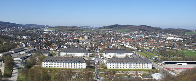
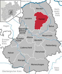
Hemer
- German town in the Märkischer Kreis district of North Rhine-Westphalia
Hiking in Hemer
Hemer, located in the North Rhine-Westphalia region of Germany, offers several beautiful hiking opportunities that showcase its natural landscapes and scenic views. Here are some highlights and tips for hiking in this area:...
- Country:
- Postal Code: 58675; 5870
- Local Dialing Code: 02372
- Licence Plate Code: MK
- Coordinates: 51° 23' 0" N, 7° 46' 0" E
- GPS tracks (wikiloc): [Link]
- AboveSeaLevel: 546 м m
- Area: 67.66 sq km
- Population: 33535
- Web site: [Link]


Iserlohn
- German city in the Märkischer Kreis district of North Rhine-Westphalia
Hiking in Iserlohn
Iserlohn is a picturesque town located in North Rhine-Westphalia, Germany, and offers a variety of excellent hiking opportunities for outdoor enthusiasts. The surrounding landscape is characterized by beautiful forests, hills, and the scenic Lenne River, making it an inviting destination for hiking....
- Country:
- Postal Code: 58636–58644
- Local Dialing Code: 02371
- Licence Plate Code: MK
- Coordinates: 51° 23' 0" N, 7° 40' 0" E
- GPS tracks (wikiloc): [Link]
- AboveSeaLevel: 253 м m
- Area: 125.49 sq km
- Population: 92928
- Web site: [Link]


Lüdenscheid
- city in North Rhine-Westphalia, Germany
Hiking in Lüdenscheid
Lüdenscheid, located in North Rhine-Westphalia, Germany, is surrounded by beautiful landscapes that make it an appealing destination for hiking enthusiasts. The region is part of the Sauerland, known for its rolling hills, forests, and serene lakes. Here are some highlights and considerations for hiking in and around Lüdenscheid:...
- Country:
- Postal Code: 58507–58515
- Local Dialing Code: 02351
- Licence Plate Code: MK
- Coordinates: 51° 13' 11" N, 7° 37' 38" E
- GPS tracks (wikiloc): [Link]
- AboveSeaLevel: 423 м m
- Area: 86.73 sq km
- Population: 72894
- Web site: [Link]

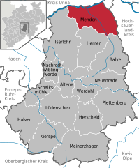
Menden (Sauerland)
- town in the district Märkischer Kreis, in North Rhine-Westphalia, Germany
Hiking in Menden (Sauerland)
Menden, located in North Rhine-Westphalia, Germany, offers several hiking opportunities that take advantage of the area's natural beauty and rich landscapes. The region features a mix of forested areas, hills, and rivers, making it suitable for hikers of various skill levels....
- Country:
- Postal Code: 58706–58710
- Local Dialing Code: 02373
- Licence Plate Code: MK
- Coordinates: 51° 26' 0" N, 7° 48' 0" E
- GPS tracks (wikiloc): [Link]
- AboveSeaLevel: 150 м m
- Area: 86.08 sq km
- Population: 53046
- Web site: [Link]

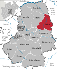
Balve
- town in the Märkischer Kreis district, North Rhine-Westphalia, Germany
Hiking in Balve
Balve is a charming town located in the Sauerland region of Germany, surrounded by picturesque landscapes and a variety of hiking opportunities. The area is known for its natural beauty, including forests, hills, and valleys, making it an excellent destination for outdoor enthusiasts....
- Country:
- Postal Code: 58802
- Local Dialing Code: 02375
- Licence Plate Code: MK
- Coordinates: 51° 20' 0" N, 7° 52' 0" E
- GPS tracks (wikiloc): [Link]
- AboveSeaLevel: 250 м m
- Area: 74.76 sq km
- Population: 11449
- Web site: [Link]


Altena
- town in the district of Märkischer Kreis, North Rhine-Westphalia, Germany
Hiking in Altena
Hiking in Altena, a picturesque town in North Rhine-Westphalia, Germany, offers a delightful experience for outdoor enthusiasts. Surrounded by lush forests, beautiful valleys, and scenic landscapes, the area is ideal for both novice and experienced hikers. Here are some highlights and tips for hiking in Altena:...
- Country:
- Postal Code: 58741–58762
- Local Dialing Code: 02352
- Coordinates: 51° 18' 0" N, 7° 40' 0" E
- GPS tracks (wikiloc): [Link]
- AboveSeaLevel: 190 м m
- Area: 44.29 sq km
- Population: 17081
- Web site: [Link]


Nachrodt-Wiblingwerde
- municipality in the Märkischer Kreis, North Rhine-Westphalia, Germany
Hiking in Nachrodt-Wiblingwerde
Nachrodt-Wiblingwerde is a picturesque municipality located in the Märkischer Kreis district of North Rhine-Westphalia, Germany. It offers beautiful landscapes and is surrounded by the scenic nature of the Sauerland region, which is well-known for its hiking opportunities....
- Country:
- Postal Code: 58769
- Local Dialing Code: 02352; 02334
- Licence Plate Code: MK
- Coordinates: 51° 19' 0" N, 7° 39' 0" E
- GPS tracks (wikiloc): [Link]
- AboveSeaLevel: 305 м m
- Area: 29.03 sq km
- Population: 6575
- Web site: [Link]

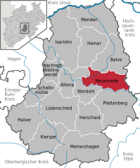
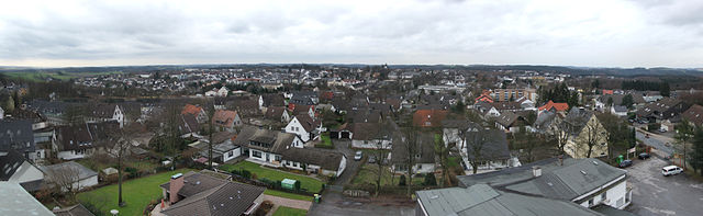
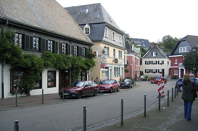
Neuenrade
- town in North Rhine-Westphalia, Germany
Hiking in Neuenrade
Neuenrade, located in North Rhine-Westphalia, Germany, offers some charming hiking opportunities amidst beautiful natural landscapes. The region is characterized by its rolling hills, woodlands, and picturesque valleys, making it an attractive destination for nature lovers and hikers. Here are some highlights of hiking in the Neuenrade area:...
- Country:
- Postal Code: 58809
- Local Dialing Code: 02394; 02392
- Licence Plate Code: MK
- Coordinates: 51° 17' 2" N, 7° 46' 48" E
- GPS tracks (wikiloc): [Link]
- AboveSeaLevel: 320 м m
- Area: 54.1 sq km
- Population: 11963
- Web site: [Link]


Plettenberg
- town in the Märkischer Kreis, in North Rhine-Westphalia, Germany
Hiking in Plettenberg
Plettenberg Bay, located along South Africa's stunning Garden Route, offers a fantastic variety of hiking opportunities in a beautiful natural setting. Here are some highlights and options for hiking in and around Plettenberg Bay:...
- Country:
- Postal Code: 58840
- Local Dialing Code: 02391
- Licence Plate Code: MK
- Coordinates: 51° 13' 0" N, 7° 53' 0" E
- GPS tracks (wikiloc): [Link]
- AboveSeaLevel: 240 м m
- Area: 96.75 sq km
- Population: 25414
- Web site: [Link]

Halver
- town in the Märkischer Kreis district, North Rhine-Westphalia, Germany
Hiking in Halver
Halver, a charming town in North Rhine-Westphalia, Germany, offers a variety of hiking opportunities that showcase the natural beauty of the region. Whether you're an experienced hiker or a beginner, there are trails suited for all levels. Here are some highlights of hiking in Halver:...
- Country:
- Postal Code: 58553
- Local Dialing Code: 02353
- Licence Plate Code: MK
- Coordinates: 51° 11' 0" N, 7° 28' 0" E
- GPS tracks (wikiloc): [Link]
- AboveSeaLevel: 414 м m
- Area: 77.23 sq km
- Population: 16128
- Web site: [Link]


Kierspe
- town in the district Märkischer Kreis, in North Rhine-Westphalia, Germany
Hiking in Kierspe
Kierspe is a charming town located in the North Rhine-Westphalia region of Germany, nestled in the beautiful Sauerland area. The region is known for its scenic landscapes, lush forests, and rolling hills, making it an excellent destination for hiking enthusiasts....
- Country:
- Postal Code: 58566
- Local Dialing Code: 02359
- Licence Plate Code: MK
- Coordinates: 51° 8' 0" N, 7° 34' 0" E
- GPS tracks (wikiloc): [Link]
- AboveSeaLevel: 431 м m
- Area: 71.91 sq km
- Population: 16210
- Web site: [Link]
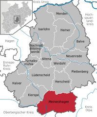
Meinerzhagen
- town in the Märkischer Kreis, North Rhine-Westphalia, Germany
Hiking in Meinerzhagen
Meinerzhagen, located in North Rhine-Westphalia, Germany, is a charming town surrounded by scenic landscapes, making it a great destination for hiking enthusiasts. The area offers various trails that cater to different skill levels, from easy walks suitable for families to more challenging hikes for experienced trekkers....
- Country:
- Postal Code: 58540
- Local Dialing Code: 02763; 02358; 02357; 02354
- Licence Plate Code: MK
- Coordinates: 51° 7' 0" N, 7° 38' 0" E
- GPS tracks (wikiloc): [Link]
- AboveSeaLevel: 399 м m
- Area: 115.18 sq km
- Population: 20406
- Web site: [Link]


Werdohl
- town in the district Märkischer Kreis, in North Rhine-Westphalia, Germany
Hiking in Werdohl
Werdohl, located in North Rhine-Westphalia, Germany, is surrounded by picturesque landscapes, making it an excellent spot for hiking enthusiasts. Here are some highlights and tips for hiking in the area:...
- Country:
- Postal Code: 58791
- Local Dialing Code: 02392
- Licence Plate Code: MK
- Coordinates: 51° 16' 0" N, 7° 46' 0" E
- GPS tracks (wikiloc): [Link]
- AboveSeaLevel: 210 м m
- Area: 33.38 sq km
- Population: 17833
- Web site: [Link]


Herscheid
- municipality in Märkischer Kreis, in North Rhine-Westphalia, Germany
Hiking in Herscheid
Herscheid is a beautiful town located in the Sauerland region of Germany, known for its stunning landscapes, rolling hills, and lush forests, making it an excellent destination for hiking enthusiasts. Here are some highlights and tips for hiking in and around Herscheid:...
- Country:
- Postal Code: 58849
- Local Dialing Code: 02357
- Licence Plate Code: MK
- Coordinates: 51° 10' 38" N, 7° 44' 45" E
- GPS tracks (wikiloc): [Link]
- AboveSeaLevel: 430 м m
- Area: 58.92 sq km
- Population: 7052
- Web site: [Link]

Schalksmühle
- Municipality in North-Rhine Westfalia, Germany
Hiking in Schalksmühle
Schalksmühle is a scenic municipality located in North Rhine-Westphalia, Germany, known for its beautiful natural landscapes and outdoor activities, including hiking. Here are some highlights and tips for hiking in Schalksmühle:...
- Country:
- Postal Code: 58579
- Local Dialing Code: 02355; 02351; 02337
- Licence Plate Code: MK
- Coordinates: 51° 14' 0" N, 7° 32' 0" E
- GPS tracks (wikiloc): [Link]
- AboveSeaLevel: 250 м m
- Area: 38.2 sq km
- Population: 10388
- Web site: [Link]
Shares border with regions:


Ennepe-Ruhr-Kreis
- district in North Rhine-Westphalia, Germany
Hiking in Ennepe-Ruhr-Kreis
Ennepe-Ruhr-Kreis, located in North Rhine-Westphalia, Germany, is an excellent destination for hiking enthusiasts. The region is characterized by its diverse landscapes, which include forests, hills, and scenic views of the Ruhr area. Here are some key points to consider when hiking in this region:...
- Country:
- Capital: Schwelm
- Licence Plate Code: WIT; EN
- Coordinates: 51° 21' 5" N, 7° 18' 26" E
- GPS tracks (wikiloc): [Link]
- AboveSeaLevel: 226 м m
- Area: 408.44 sq km
- Population: 322731
- Web site: [Link]

Hagen
- German city in North Rhine-Westphalia
Hiking in Hagen
Hagen, located in North Rhine-Westphalia, Germany, offers a variety of hiking opportunities that showcase the area's natural beauty and diverse landscapes. Here are some highlights and tips for hiking in and around Hagen:...
- Country:
- Postal Code: 58000–58135
- Local Dialing Code: 02331; 02304; 02337; 02334
- Licence Plate Code: HA
- Coordinates: 51° 21' 34" N, 7° 28' 30" E
- GPS tracks (wikiloc): [Link]
- AboveSeaLevel: 106 м m
- Area: 160.45 sq km
- Population: 188266
- Web site: [Link]
Hochsauerlandkreis
- district in North Rhine-Westphalia, Germany
Hiking in Hochsauerlandkreis
Hochsauerlandkreis, located in North Rhine-Westphalia, Germany, is known for its stunning natural landscapes and well-marked hiking trails. The area is characterized by rolling hills, dense forests, and picturesque villages, making it a great destination for hikers of all experience levels....
- Country:
- Licence Plate Code: HSK
- Coordinates: 51° 17' 57" N, 8° 20' 33" E
- GPS tracks (wikiloc): [Link]
- AboveSeaLevel: 577 м m
- Area: 1958.78 sq km
- Population: 268851
- Web site: [Link]
Olpe
- district in North Rhine-Westphalia, Germany
Hiking in Olpe
Olpe is a picturesque district located in the North Rhine-Westphalia region of Germany, known for its scenic landscapes, charming villages, and outdoor recreational opportunities, making it a great destination for hiking enthusiasts. Here are some key highlights about hiking in Olpe:...
- Country:
- Licence Plate Code: OE
- Coordinates: 51° 4' 48" N, 8° 0' 0" E
- GPS tracks (wikiloc): [Link]
- AboveSeaLevel: 334 м m
- Web site: [Link]
Soest
- district in North Rhine-Westphalia, Germany
Hiking in Soest
Soest is a district located in North Rhine-Westphalia, Germany, known for its scenic landscapes, historical sites, and outdoor recreational opportunities. Hiking in the Soest area can be a delightful experience due to its diverse terrain, including forests, hills, and waterways....
- Country:
- Licence Plate Code: SO
- Coordinates: 51° 34' 48" N, 8° 15' 0" E
- GPS tracks (wikiloc): [Link]
- AboveSeaLevel: 137 м m
- Web site: [Link]


Unna
- district in North Rhine-Westphalia, Germany
Hiking in Unna
Unna is a district located in North Rhine-Westphalia, Germany, known for its beautiful landscapes and diverse recreational opportunities, including hiking. The region attracts outdoors enthusiasts due to its varied terrains, which can range from gentle hills to river valleys and forests....
- Country:
- Capital: Unna
- Licence Plate Code: UN
- Coordinates: 51° 34' 48" N, 7° 40' 12" E
- GPS tracks (wikiloc): [Link]
- AboveSeaLevel: 70 м m
- Web site: [Link]