Arnsberg Government Region (Regierungsbezirk Arnsberg)

- government region of North Rhine-Westphalia, Germany
 Hiking in Arnsberg Government Region
Arnsberg, a charming region located in North Rhine-Westphalia, Germany, offers a wealth of opportunities for hiking enthusiasts. Nestled in the heart of the Sauerland, the area boasts varied landscapes, including dense forests, rolling hills, and picturesque valleys.
Key Features of Hiking in Arnsberg:
-
Diverse Trails: The region is home to numerous well-marked trails suitable for all levels of hikers, from beginners to experienced trekkers. Popular trails include the Rothaarsteig, a long-distance hiking path stretching across the Sauerland, and circular routes that explore the scenic beauty of the region.
-
Natural Beauty: Hikers can enjoy stunning views of the surrounding landscapes, including the unique rock formations and lush greenery. The region is part of the Arnsberger Wald, which is a vast forest area providing a peaceful atmosphere and a chance to encounter local wildlife.
-
Cultural Heritage: Along the trails, you may discover historical landmarks, such as old castles, ruins, and charming villages that showcase the rich history and culture of the area. The town of Arnsberg itself has a medieval old town with well-preserved buildings.
-
Accessibility: Many trails are easily accessible from the town center or surrounding areas, making it convenient for day hikes. Public transport options can also help hikers reach various starting points.
-
Seasonal Opportunities: Each season presents a different hiking experience; spring brings blooming flowers, summer offers lush greenery, autumn showcases vibrant foliage, and winter can transform the landscape into a magical wonderland.
-
Guided Tours: For those who prefer a guided experience, various local organizations offer guided hiking tours that can provide insights into the region’s flora, fauna, and history.
Tips for Hiking in Arnsberg:
- Equipment: Ensure you have proper hiking gear, including sturdy shoes, weather-appropriate clothing, and enough water and snacks.
- Maps and Apps: Use a good hiking map or mobile app to navigate the trails, as some areas may not have cell service.
- Weather Check: Always check the weather forecast before heading out, as conditions can change quickly.
- Respect Nature: Follow Leave No Trace principles to preserve the natural beauty of the area, including respecting wildlife and staying on marked trails.
Whether you're looking for a leisurely stroll or a more challenging hike, Arnsberg offers a wonderful destination for outdoor activities amidst beautiful landscapes and rich cultural history. Happy hiking!
- Country:

- Coordinates: 51° 19' 47" N, 8° 0' 26" E


- GPS tracks (wikiloc): [Link]
- AboveSeaLevel: 252 м m
- Web site: https://www.bezreg-arnsberg.nrw.de/
- Wikipedia en: wiki(en)
- Wikipedia: wiki(de)
- Wikidata storage: Wikidata: Q7924
- Wikipedia Commons Category: [Link]
- Wikipedia Commons Maps Category: [Link]
- Freebase ID: [/m/0199d4]
- GeoNames ID: Alt: [2955470]
- VIAF ID: Alt: [151281956]
- OSM relation ID: [73340]
- GND ID: Alt: [4003008-8]
- Twitter username: Alt: [BezRegArnsberg]
- NUTS code: [DEA5]
- GNS Unique Feature ID: -1741105
Includes regions:


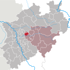
Ennepe-Ruhr-Kreis
- district in North Rhine-Westphalia, Germany
Hiking in Ennepe-Ruhr-Kreis
Ennepe-Ruhr-Kreis, located in North Rhine-Westphalia, Germany, is an excellent destination for hiking enthusiasts. The region is characterized by its diverse landscapes, which include forests, hills, and scenic views of the Ruhr area. Here are some key points to consider when hiking in this region:...
- Country:
- Capital: Schwelm
- Licence Plate Code: WIT; EN
- Coordinates: 51° 21' 5" N, 7° 18' 26" E
- GPS tracks (wikiloc): [Link]
- AboveSeaLevel: 226 м m
- Area: 408.44 sq km
- Population: 322731
- Web site: [Link]


Dortmund
- town in North Rhine-Westphalia, Germany
Hiking in Dortmund
Dortmund, located in the North Rhine-Westphalia region of Germany, is not only known for its industrial heritage but also offers various opportunities for hiking and enjoying nature. Here are some highlights and tips for hiking in Dortmund:...
- Country:
- Postal Code: 44135–44388
- Local Dialing Code: 02304; 0231
- Licence Plate Code: DO
- Coordinates: 51° 30' 50" N, 7° 27' 55" E
- GPS tracks (wikiloc): [Link]
- AboveSeaLevel: 86 м m
- Area: 280.71 sq km
- Population: 585813
- Web site: [Link]

Bochum
- city in North Rhine-Westphalia, Germany
Hiking in Bochum
Bochum, located in the North Rhine-Westphalia region of Germany, is not traditionally known as a hiking destination, but it offers some interesting opportunities for outdoor enthusiasts. Here are a few highlights for hiking in and around Bochum:...
- Country:
- Postal Code: 44701–44894
- Local Dialing Code: 02327; 0234
- Licence Plate Code: BO
- Coordinates: 51° 29' 0" N, 7° 13' 0" E
- GPS tracks (wikiloc): [Link]
- AboveSeaLevel: 100 м m
- Area: 145.66 sq km
- Population: 364920
- Web site: [Link]

Hagen
- German city in North Rhine-Westphalia
Hiking in Hagen
Hagen, located in North Rhine-Westphalia, Germany, offers a variety of hiking opportunities that showcase the area's natural beauty and diverse landscapes. Here are some highlights and tips for hiking in and around Hagen:...
- Country:
- Postal Code: 58000–58135
- Local Dialing Code: 02331; 02304; 02337; 02334
- Licence Plate Code: HA
- Coordinates: 51° 21' 34" N, 7° 28' 30" E
- GPS tracks (wikiloc): [Link]
- AboveSeaLevel: 106 м m
- Area: 160.45 sq km
- Population: 188266
- Web site: [Link]


Hamm
- town in North Rhine-Westphalia, Germany
Hiking in Hamm
Hamm, located in the North Rhine-Westphalia region of Germany, offers a variety of hiking opportunities that cater to different skill levels and interests. While it may not be as famous for hiking as some other regions in Germany, it features several trails that allow hikers to enjoy the natural beauty and cultural landscapes of the area....
- Country:
- Postal Code: 59001–59077
- Local Dialing Code: 02389; 02388; 02307
- Licence Plate Code: HAM
- Coordinates: 51° 40' 19" N, 7° 49' 30" E
- GPS tracks (wikiloc): [Link]
- AboveSeaLevel: 63 м m
- Area: 226.43 sq km
- Population: 179571
- Web site: [Link]


Herne
- town in North Rhine-Westphalia, Germany
Hiking in Herne
Herne, located in North Rhine-Westphalia, Germany, may not be the first destination that comes to mind for hiking, but it offers several opportunities for outdoor enthusiasts to enjoy nature and explore the surrounding landscapes. Here’s what you need to know about hiking in and around Herne:...
- Country:
- Postal Code: 44601–44653
- Local Dialing Code: 02323; 02325
- Licence Plate Code: WAN; HER
- Coordinates: 51° 32' 33" N, 7° 13' 8" E
- GPS tracks (wikiloc): [Link]
- AboveSeaLevel: 65 м m
- Area: 51.42 sq km
- Population: 156774
- Web site: [Link]
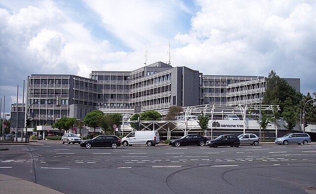

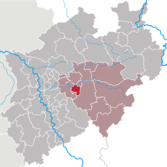
Märkischer Kreis
- district in central North Rhine-Westphalia, Germany
Hiking in Märkischer Kreis
Märkischer Kreis, located in North Rhine-Westphalia, Germany, is a beautiful region for hiking enthusiasts. It offers a blend of natural landscapes, charming small towns, and cultural heritage. Here are some highlights and things to know about hiking in this area:...
- Country:
- Capital: Lüdenscheid
- Licence Plate Code: MK
- Coordinates: 51° 13' 30" N, 7° 36' 52" E
- GPS tracks (wikiloc): [Link]
- AboveSeaLevel: 186 м m
- Area: 1058.95 sq km
- Population: 416171
- Web site: [Link]
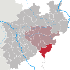
Hochsauerlandkreis
- district in North Rhine-Westphalia, Germany
Hiking in Hochsauerlandkreis
Hochsauerlandkreis, located in North Rhine-Westphalia, Germany, is known for its stunning natural landscapes and well-marked hiking trails. The area is characterized by rolling hills, dense forests, and picturesque villages, making it a great destination for hikers of all experience levels....
- Country:
- Licence Plate Code: HSK
- Coordinates: 51° 17' 57" N, 8° 20' 33" E
- GPS tracks (wikiloc): [Link]
- AboveSeaLevel: 577 м m
- Area: 1958.78 sq km
- Population: 268851
- Web site: [Link]
Olpe
- district in North Rhine-Westphalia, Germany
Hiking in Olpe
Olpe is a picturesque district located in the North Rhine-Westphalia region of Germany, known for its scenic landscapes, charming villages, and outdoor recreational opportunities, making it a great destination for hiking enthusiasts. Here are some key highlights about hiking in Olpe:...
- Country:
- Licence Plate Code: OE
- Coordinates: 51° 4' 48" N, 8° 0' 0" E
- GPS tracks (wikiloc): [Link]
- AboveSeaLevel: 334 м m
- Web site: [Link]
Soest
- district in North Rhine-Westphalia, Germany
Hiking in Soest
Soest is a district located in North Rhine-Westphalia, Germany, known for its scenic landscapes, historical sites, and outdoor recreational opportunities. Hiking in the Soest area can be a delightful experience due to its diverse terrain, including forests, hills, and waterways....
- Country:
- Licence Plate Code: SO
- Coordinates: 51° 34' 48" N, 8° 15' 0" E
- GPS tracks (wikiloc): [Link]
- AboveSeaLevel: 137 м m
- Web site: [Link]

Siegen-Wittgenstein
- district in North Rhine-Westphalia, Germany
Hiking in Siegen-Wittgenstein
Siegen-Wittgenstein is a beautiful region located in North Rhine-Westphalia, Germany, characterized by its lush landscapes, rolling hills, and dense forests. This area is perfect for hiking enthusiasts, offering a variety of trails suitable for all skill levels....
- Country:
- Licence Plate Code: BLB; SI
- Coordinates: 50° 55' 12" N, 8° 10' 12" E
- GPS tracks (wikiloc): [Link]
- AboveSeaLevel: 616 м m
- Area: 1132.89 sq km
- Population: 275909
- Web site: [Link]


Unna
- district in North Rhine-Westphalia, Germany
Hiking in Unna
Unna is a district located in North Rhine-Westphalia, Germany, known for its beautiful landscapes and diverse recreational opportunities, including hiking. The region attracts outdoors enthusiasts due to its varied terrains, which can range from gentle hills to river valleys and forests....
- Country:
- Capital: Unna
- Licence Plate Code: UN
- Coordinates: 51° 34' 48" N, 7° 40' 12" E
- GPS tracks (wikiloc): [Link]
- AboveSeaLevel: 70 м m
- Web site: [Link]