Saint-Cernin (Saint-Cernin)

- commune in Cantal, France
- Country:

- Postal Code: 15310
- Coordinates: 45° 3' 31" N, 2° 25' 15" E


- GPS tracks (wikiloc): [Link]
- Area: 46.75 sq km
- Population: 1087
- Web site: http://Saint-Cernin.fr
- Wikipedia en: wiki(en)
- Wikipedia: wiki(fr)
- Wikidata storage: Wikidata: Q664037
- Wikipedia Commons Category: [Link]
- Freebase ID: [/m/03mb9r7]
- GeoNames ID: Alt: [6427625]
- SIREN number: [211501754]
- BnF ID: [15248345r]
- INSEE municipality code: 15175
Shares border with regions:
Freix-Anglards
- commune in Cantal, France
- Country:
- Postal Code: 15310
- Coordinates: 45° 1' 17" N, 2° 23' 10" E
- GPS tracks (wikiloc): [Link]
- AboveSeaLevel: 800 м m
- Area: 17.69 sq km
- Population: 210


Saint-Illide
- commune in Cantal, France
- Country:
- Postal Code: 15310
- Coordinates: 45° 3' 42" N, 2° 18' 54" E
- GPS tracks (wikiloc): [Link]
- Area: 39.71 sq km
- Population: 656
- Web site: [Link]


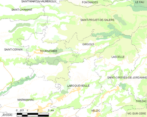
Tournemire
- commune in Cantal, France
- Country:
- Postal Code: 15310
- Coordinates: 45° 3' 16" N, 2° 28' 56" E
- GPS tracks (wikiloc): [Link]
- Area: 9.68 sq km
- Population: 123

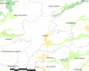
Jussac
- commune in Cantal, France
- Country:
- Postal Code: 15250
- Coordinates: 44° 59' 15" N, 2° 25' 23" E
- GPS tracks (wikiloc): [Link]
- Area: 18.43 sq km
- Population: 2015
- Web site: [Link]


Marmanhac
- commune in Cantal, France
- Country:
- Postal Code: 15250
- Coordinates: 45° 0' 13" N, 2° 28' 56" E
- GPS tracks (wikiloc): [Link]
- Area: 24.24 sq km
- Population: 712

Girgols
- commune in Cantal, France
- Country:
- Postal Code: 15310
- Coordinates: 45° 2' 18" N, 2° 28' 53" E
- GPS tracks (wikiloc): [Link]
- Area: 12.62 sq km
- Population: 77


Saint-Chamant
- commune in Cantal, France
- Country:
- Postal Code: 15140
- Coordinates: 45° 5' 27" N, 2° 26' 21" E
- GPS tracks (wikiloc): [Link]
- Area: 13.72 sq km
- Population: 234
Saint-Cirgues-de-Malbert
- commune in Cantal, France
- Country:
- Postal Code: 15140
- Coordinates: 45° 5' 54" N, 2° 23' 36" E
- GPS tracks (wikiloc): [Link]
- Area: 16.21 sq km
- Population: 249

Saint-Projet-de-Salers
- commune in Cantal, France
- Country:
- Postal Code: 15140
- Coordinates: 45° 5' 8" N, 2° 31' 36" E
- GPS tracks (wikiloc): [Link]
- Area: 36.32 sq km
- Population: 138