Katsdorf (Katsdorf)
- municipality in Austria
Katsdorf, located in the Upper Austria region, offers several charming hiking opportunities. The area is characterized by beautiful countryside, rolling hills, and scenic views, making it ideal for both beginners and experienced hikers.
Here are a few highlights to keep in mind when hiking in Katsdorf:
-
Varied Trails: There are different trails ranging from easy walks suitable for families to more challenging hikes that can take you through forests and over hills. Make sure to check local maps or apps for the best routes.
-
Natural Beauty: The region is abundant in natural beauty, including lush green fields, wooded areas, and picturesque landscapes. This is perfect for photography enthusiasts or those looking to enjoy peaceful surroundings.
-
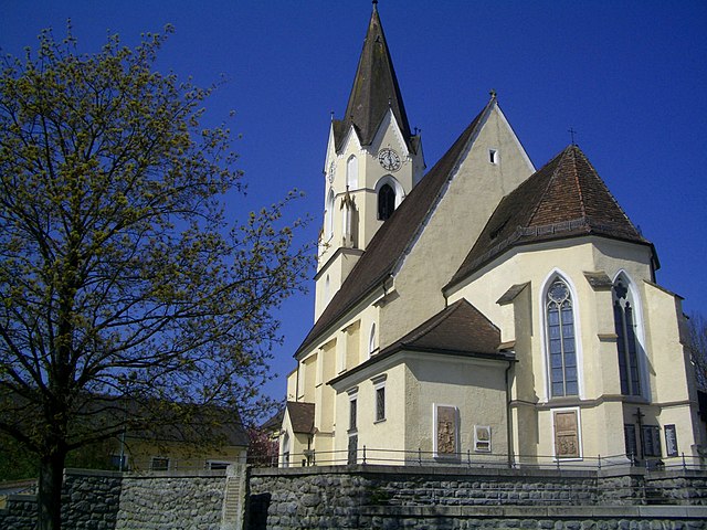
Cultural Sites: While hiking, you may encounter local cultural sites, including churches and historical monuments, which can add an educational aspect to your hike.
-
Accessibility: The trails around Katsdorf are generally well-marked and accessible, making it easy to navigate whether you're on a day hike or a longer trek.
-
Weather Considerations: As with any hiking location, it's important to check the weather forecast before you head out. Conditions can change rapidly, especially in mountainous areas, so be prepared with appropriate clothing and equipment.
-
Local Wildlife: Keep an eye out for local wildlife. The area is home to various species of birds and other wildlife that you might spot along the way.
-
Safety First: Always let someone know your hiking plans, especially if you plan to go solo. Bring sufficient water, snacks, and a first aid kit, and consider hiking with a buddy for added safety.
Overall, hiking in Katsdorf can be a rewarding experience with its combination of natural beauty and cultural richness. Be sure to explore and enjoy the great outdoors!
- Country:

- Postal Code: 4223
- Local Dialing Code: 07235
- Licence Plate Code: PE
- Coordinates: 48° 19' 1" N, 14° 28' 27" E


- GPS tracks (wikiloc): [Link]
- AboveSeaLevel: 306 м m
- Area: 14.66 sq km
- Population: 3086
- Web site: http://www.katsdorf.at/
- Wikipedia en: wiki(en)
- Wikipedia: wiki(de)
- Wikidata storage: Wikidata: Q677247
- Wikipedia Commons Category: [Link]
- Wikipedia Commons Maps Category: [Link]
- Freebase ID: [/m/03gv79g]
- GeoNames ID: Alt: [7872065]
- VIAF ID: Alt: [235696563]
- GND ID: Alt: [4811168-5]
- Austrian municipality key: [41106]
Shares border with regions:

Sankt Georgen an der Gusen
- municipality in Austria
 Hiking in Sankt Georgen an der Gusen
Sankt Georgen an der Gusen is a picturesque town located in Austria, known for its historical significance and beautiful landscapes. While it may not be as popular as some other hiking destinations in the region, it offers a variety of trails and outdoor activities for hiking enthusiasts....
- Country:

- Local Dialing Code: 07237
- Licence Plate Code: PE
- Coordinates: 48° 16' 18" N, 14° 26' 54" E


- GPS tracks (wikiloc): [Link]
- AboveSeaLevel: 262 м m
- Area: 7.12 sq km
- Population: 4119
- Web site: [Link]

Engerwitzdorf
- municipality in Austria
Engerwitzdorf, located in Austria, offers a variety of scenic hiking opportunities for both casual walkers and more experienced hikers. The region is characterized by its picturesque landscapes, lush forests, and rolling hills, making it an ideal destination for nature lovers....
- Country:

- Postal Code: 4209
- Local Dialing Code: 0 72 35
- Licence Plate Code: UU
- Coordinates: 48° 20' 23" N, 14° 25' 32" E


- GPS tracks (wikiloc): [Link]
- AboveSeaLevel: 333 м m
- Area: 41.09 sq km
- Population: 8790
- Web site: [Link]


Ried in der Riedmark
- municipality in Austria
 Hiking in Ried in der Riedmark
Ried in der Riedmark is a charming municipality located in Austria, nestled in the scenic landscape of Upper Austria. The area offers various hiking opportunities for both beginners and more experienced hikers, making it a great destination for outdoor enthusiasts....
- Country:

- Postal Code: 4312
- Local Dialing Code: 07238
- Licence Plate Code: PE
- Coordinates: 48° 16' 16" N, 14° 32' 44" E


- GPS tracks (wikiloc): [Link]
- AboveSeaLevel: 306 м m
- Area: 32.6 sq km
- Population: 4210
- Web site: [Link]

Wartberg ob der Aist
- municipality in Austria
 Hiking in Wartberg ob der Aist
Wartberg ob der Aist is a charming municipality located in the northern region of Upper Austria, surrounded by beautiful landscapes that make it an excellent destination for hiking enthusiasts. The area is characterized by scenic hills, lush forests, and tranquil rivers, providing a variety of hiking trails suitable for different skill levels....
- Country:

- Postal Code: 4224
- Local Dialing Code: 07236
- Licence Plate Code: FR
- Coordinates: 48° 20' 50" N, 14° 30' 30" E


- GPS tracks (wikiloc): [Link]
- AboveSeaLevel: 477 м m
- Area: 19.4 sq km
- Population: 4222
- Web site: [Link]