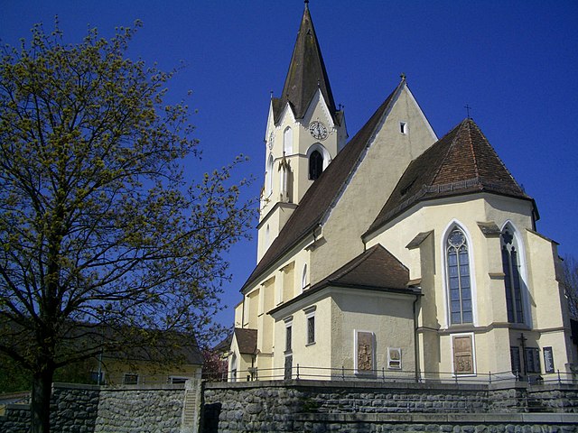
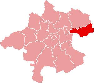
Wartberg ob der Aist (Wartberg ob der Aist)
- municipality in Austria
 Hiking in Wartberg ob der Aist
Wartberg ob der Aist is a charming municipality located in the northern region of Upper Austria, surrounded by beautiful landscapes that make it an excellent destination for hiking enthusiasts. The area is characterized by scenic hills, lush forests, and tranquil rivers, providing a variety of hiking trails suitable for different skill levels.
Hiking Options:
-
Trail Variety: There are several marked hiking trails in and around Wartberg ob der Aist. These include easy walks suitable for families as well as more challenging routes for experienced hikers. Trails often feature picturesque views of the Aist river valley and surrounding countryside.
-
Nature and Scenery: The region boasts a rich natural environment with diverse flora and fauna. Expect to see beautiful forests, fields, and possibly some wildlife along the trails. The changing seasons also offer stunning scenery, especially in autumn when the foliage is at its peak.
-
Trail Length: Most trails vary in length, allowing for short walks or longer hikes of several hours. Always check trail signs or local resources for estimated times and distances to gauge your ability and endurance.
-
Guided Tours: If you prefer expert guidance, there may be local hiking tours available that can provide insight into the area's ecology and history, enhancing your hiking experience.
-
Nearby Attractions: The region is not just about hiking. You can explore local cultural sites, such as historical buildings and villages, or enjoy a day in one of the nearby natural parks for a more rounded outdoor experience.
Tips for Hiking in Wartberg ob der Aist:
- Prepare Adequately: Depending on the length and remoteness of the trails, make sure to wear appropriate footwear, bring sufficient water, snacks, and a basic first aid kit.
- Check Weather Conditions: Weather can change quickly in mountainous areas, so it's always a good idea to check the forecast before heading out and be prepared for varying conditions.
- Leave No Trace: Respect the natural environment by following the Leave No Trace principles—take your trash with you, stay on marked trails, and avoid disturbing wildlife.
- Navigation: Although trails are marked, consider carrying a map or downloading offline maps on your mobile device as a precaution.
In summary, Wartberg ob der Aist offers a delightful experience for hikers, combining nature, exercise, and the opportunity to enjoy the great outdoors in the beautiful landscape of Upper Austria. Enjoy your hike!
- Country:

- Postal Code: 4224
- Local Dialing Code: 07236
- Licence Plate Code: FR
- Coordinates: 48° 20' 50" N, 14° 30' 30" E


- GPS tracks (wikiloc): [Link]
- AboveSeaLevel: 477 м m
- Area: 19.4 sq km
- Population: 4222
- Web site: http://www.wartberg-aist.at/
- Wikipedia en: wiki(en)
- Wikipedia: wiki(de)
- Wikidata storage: Wikidata: Q683270
- Wikipedia Commons Category: [Link]
- Freebase ID: [/m/03gv3pb]
- GeoNames ID: Alt: [2761877]
- VIAF ID: Alt: [234771945]
- Austrian municipality key: [40624]
Shares border with regions:


Hagenberg im Mühlkreis
- municipality in Austria
 Hiking in Hagenberg im Mühlkreis
Hagenberg im Mühlkreis is a charming village in Austria, located in the beautiful Mühlviertel region, which is known for its lush green landscapes, rolling hills, and picturesque views. Here’s what you can expect when hiking in this area:...
- Country:

- Postal Code: 4232
- Local Dialing Code: 07236
- Licence Plate Code: FR
- Coordinates: 48° 21' 50" N, 14° 31' 10" E


- GPS tracks (wikiloc): [Link]
- AboveSeaLevel: 444 м m
- Area: 15.1 sq km
- Population: 2737
- Web site: [Link]

Unterweitersdorf
- municipality in Austria
Unterweitersdorf is a picturesque village located in Austria, surrounded by beautiful landscapes that offer a variety of hiking opportunities. When exploring this area, you can find trails that wind through forests, fields, and along rivers, showcasing the stunning natural scenery of the region....
- Country:

- Postal Code: 4210
- Local Dialing Code: 07235
- Licence Plate Code: FR
- Coordinates: 48° 22' 0" N, 14° 28' 0" E


- GPS tracks (wikiloc): [Link]
- AboveSeaLevel: 333 м m
- Area: 11.4 sq km
- Population: 2082
- Web site: [Link]

Engerwitzdorf
- municipality in Austria
Engerwitzdorf, located in Austria, offers a variety of scenic hiking opportunities for both casual walkers and more experienced hikers. The region is characterized by its picturesque landscapes, lush forests, and rolling hills, making it an ideal destination for nature lovers....
- Country:

- Postal Code: 4209
- Local Dialing Code: 0 72 35
- Licence Plate Code: UU
- Coordinates: 48° 20' 23" N, 14° 25' 32" E


- GPS tracks (wikiloc): [Link]
- AboveSeaLevel: 333 м m
- Area: 41.09 sq km
- Population: 8790
- Web site: [Link]

Pregarten
- municipality in Austria
Pregarten, located in Upper Austria, is a charming town that serves as a gateway for various outdoor activities, including hiking. The surrounding landscape is characterized by gently rolling hills, lush forests, and picturesque natural scenery, making it an excellent destination for both beginner and experienced hikers....
- Country:

- Postal Code: 4230
- Local Dialing Code: 07236
- Licence Plate Code: FR
- Coordinates: 48° 21' 20" N, 14° 31' 50" E


- GPS tracks (wikiloc): [Link]
- AboveSeaLevel: 425 м m
- Area: 27.8 sq km
- Population: 5293
- Web site: [Link]

Katsdorf
- municipality in Austria
Katsdorf, located in the Upper Austria region, offers several charming hiking opportunities. The area is characterized by beautiful countryside, rolling hills, and scenic views, making it ideal for both beginners and experienced hikers....
- Country:

- Postal Code: 4223
- Local Dialing Code: 07235
- Licence Plate Code: PE
- Coordinates: 48° 19' 1" N, 14° 28' 27" E


- GPS tracks (wikiloc): [Link]
- AboveSeaLevel: 306 м m
- Area: 14.66 sq km
- Population: 3086
- Web site: [Link]


Ried in der Riedmark
- municipality in Austria
 Hiking in Ried in der Riedmark
Ried in der Riedmark is a charming municipality located in Austria, nestled in the scenic landscape of Upper Austria. The area offers various hiking opportunities for both beginners and more experienced hikers, making it a great destination for outdoor enthusiasts....
- Country:

- Postal Code: 4312
- Local Dialing Code: 07238
- Licence Plate Code: PE
- Coordinates: 48° 16' 16" N, 14° 32' 44" E


- GPS tracks (wikiloc): [Link]
- AboveSeaLevel: 306 м m
- Area: 32.6 sq km
- Population: 4210
- Web site: [Link]