Kirchenfeld-Schosshalde (Kirchenfeld-Schosshalde)

- district IV of six districts of the city of Bern, Switzerland
 Hiking in Kirchenfeld-Schosshalde
Kirchenfeld-Schosshalde is an urban district located in Bern, Switzerland, known for its picturesque views and green spaces. While it may not offer extensive hiking trails typical of mountainous areas, there are still several enjoyable walking and hiking opportunities within and around this district. Here’s what to expect:
Scenic Walks
-
Aare River Walks: The Aare River runs near the district, offering lovely riverside paths that are perfect for leisurely walks. You can enjoy the scenery of the river while also having the opportunity to spot various wildlife.
-
Grosser Schanze: This large park is located not far from Kirchenfeld-Schosshalde and offers grassy areas, gardens, and walking paths with fantastic views of the city and the Alps in the distance.
Urban Hiking
- City Trails: The area boasts historic architecture and beautiful urban landscapes, making for interesting urban hikes. Strolling through the streets, you can discover the famous Zytglogge clock tower and numerous cultural sights.
Nearby Nature Areas
- Rosengarten: Just a short walk away, this public park offers stunning views over the city and beautiful rose gardens. It's a great spot for a picnic after a short hike.
- Elfenau Park: Located a bit further but accessible via trails or public transport, the Elfenau Park provides wooded paths that are perfect for a more secluded hiking experience.
Tips
- Footwear: While the trails are generally easy, wearing comfortable walking shoes is advisable.
- Weather: Always check the weather forecast before heading out, as conditions can change rapidly in the region.
- Public Transport: Utilize the excellent public transportation system in Bern for easier access to various hiking spots.
Combining Activities
If you’re looking to make a day of it, consider combining hiking with visits to local cafes, or even museums in the area to enrich your experience.
In summary, while Kirchenfeld-Schosshalde may not provide the rugged hiking trails found in Swiss mountain regions, it offers charming walking routes and nearby parks, perfect for those looking for a gentle hike in a beautiful urban setting. Enjoy your adventure!
- Country:

- Coordinates: 46° 56' 55" N, 7° 28' 19" E


- GPS tracks (wikiloc): [Link]
- Population: 20876
- Wikidata storage: Wikidata: Q1743108
- Wikipedia Commons Category: [Link]
Includes regions:

Kirchenfeld
- quarter/
Hiking in Kirchenfeld
Kirchenfeld is a charming district in Bern, Switzerland, known for its beautiful views, historical architecture, and proximity to nature. While Kirchenfeld itself may not have extensive hiking trails directly within the district, it serves as an excellent starting point for various walking and hiking excursions around Bern and further afield in the surrounding area....
- Country:
- Coordinates: 46° 56' 25" N, 7° 27' 0" E
- GPS tracks (wikiloc): [Link]

Gryphenhübeli
- quarter/
Hiking in Gryphenhübeli
Gryphenhübeli is a picturesque hiking destination located in Switzerland, known for its stunning landscapes, diverse flora, and fauna. The area offers a variety of trails suitable for hikers of all levels, from casual walkers to experienced trekkers....
- Country:
- Coordinates: 46° 56' 42" N, 7° 27' 21" E
- GPS tracks (wikiloc): [Link]

Schosshalde
- quarter/
Hiking in Schosshalde
Schosshalde is a scenic area located in or near Bern, Switzerland, known for its beautiful views and tranquil hiking routes. When hiking in Schosshalde, you can expect a mix of lush greenery, charming landscapes, and pathways that may lead you through wooded areas or open meadows....
- Country:
- Coordinates: 46° 56' 50" N, 7° 27' 52" E
- GPS tracks (wikiloc): [Link]

Murifeld
- quarter/
Hiking in Murifeld
Murifeld, located in Switzerland, is an area that provides beautiful hiking opportunities, especially for those who appreciate stunning landscapes and diverse natural settings. Here are some highlights and tips for hiking in Murifeld:...
- Country:
- Coordinates: 46° 56' 24" N, 7° 29' 0" E
- GPS tracks (wikiloc): [Link]
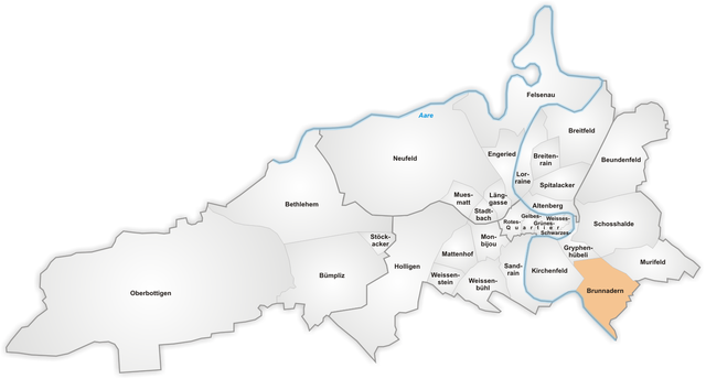
Brunnadern
- quarter/
Hiking in Brunnadern
Brunnadern is a charming village located in the canton of Appenzell Innerrhoden in Switzerland. It offers scenic landscapes, rich culture, and a variety of hiking trails that cater to different skill levels, making it an excellent destination for outdoor enthusiasts....
- Country:
- Coordinates: 46° 56' 2" N, 7° 28' 4" E
- GPS tracks (wikiloc): [Link]

Beundenfeld
- quarter/
Hiking in Beundenfeld
Beundenfeld appears to be a lesser-known location, and there may not be extensive resources or widely available information on hiking specifically in that area. However, I can help guide you on how to approach hiking in general and some tips on exploring lesser-known hiking areas....
- Country:
- Coordinates: 46° 57' 41" N, 7° 28' 22" E
- GPS tracks (wikiloc): [Link]
Shares border with regions:


inner city
- district I of six districts of the city of Bern, Switzerland
Hiking in inner city
Innere Stadt, or the "Old Town," of Bern, the capital city of Switzerland, is a UNESCO World Heritage site known for its well-preserved medieval architecture and picturesque streets. While it is not a traditional hiking destination, there are several ways to enjoy walking and exploring the area's natural beauty and surroundings. Here are some aspects to consider if you're interested in hiking or walking in and around Bern:...
- Country:
- Postal Code: 3000 - 3030
- Local Dialing Code: 031
- Licence Plate Code: BE
- Coordinates: 46° 56' 55" N, 7° 26' 52" E
- GPS tracks (wikiloc): [Link]

Mattenhof-Weissenbühl
- district III of six districts of the city of Bern, Switzerland
Hiking in Mattenhof-Weissenbühl
Mattenhof-Weissenbühl is a district in the city of Bern, Switzerland. While it may not be as famous for hiking as some of the more mountainous regions nearby, there are several opportunities for walking and enjoying nature in and around the area....
- Country:
- Coordinates: 46° 56' 19" N, 7° 25' 11" E
- GPS tracks (wikiloc): [Link]
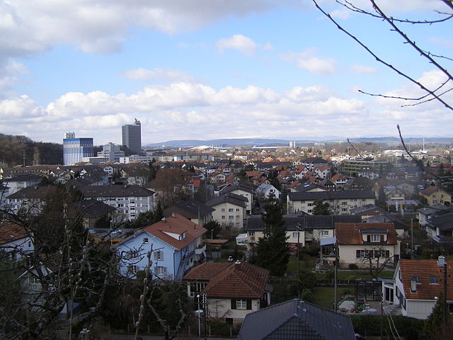
Ostermundigen
- municipality in Switzerland
Hiking in Ostermundigen
Ostermundigen, located near Bern, Switzerland, offers a variety of hiking opportunities that cater to different skill levels and preferences. Here are some highlights and tips for hiking in this beautiful area:...
- Country:
- Postal Code: 3072
- Local Dialing Code: 031
- Licence Plate Code: BE
- Coordinates: 46° 57' 21" N, 7° 29' 44" E
- GPS tracks (wikiloc): [Link]
- AboveSeaLevel: 570 м m
- Area: 5.96 sq km
- Population: 17546
- Web site: [Link]
Ittigen
- municipality in Switzerland
Hiking in Ittigen
Ittigen is a municipality located near Bern, Switzerland, and it offers a variety of opportunities for hiking enthusiasts. While Ittigen itself is more of an urban area, its proximity to the Bernese Alps and natural landscapes provides excellent access to numerous trails. Here are some aspects you might consider when hiking in and around Ittigen:...
- Country:
- Postal Code: 3063
- Local Dialing Code: 031
- Licence Plate Code: BE
- Coordinates: 46° 58' 50" N, 7° 28' 28" E
- GPS tracks (wikiloc): [Link]
- AboveSeaLevel: 552 м m
- Area: 4.2 sq km
- Population: 11335
- Web site: [Link]

Muri bei Bern
- municipality in Switzerland
Hiking in Muri bei Bern
Muri bei Bern is a charming municipality located near the capital city of Bern in Switzerland. It offers beautiful landscapes, picturesque rural settings, and numerous hiking trails that cater to different skill levels. Here's what you can expect when hiking in this region:...
- Country:
- Postal Code: 3074
- Local Dialing Code: 031
- Licence Plate Code: BE
- Coordinates: 46° 55' 55" N, 7° 29' 14" E
- GPS tracks (wikiloc): [Link]
- AboveSeaLevel: 558 м m
- Area: 7.6 sq km
- Population: 13058
- Web site: [Link]

Breitenrain-Lorraine
- district V of six districts of the city of Bern, Switzerland
Hiking in Breitenrain-Lorraine
Breitenrain-Lorraine, located in Bern, Switzerland, is a charming neighborhood that retains a blend of urban and natural landscapes. While it may not be a traditional hiking destination, there are several opportunities for walking and enjoying the outdoors in and around the area....
- Country:
- Coordinates: 46° 57' 45" N, 7° 27' 17" E
- GPS tracks (wikiloc): [Link]