Kolbsheim (Kolbsheim)

- commune in Bas-Rhin, France
- Country:

- Postal Code: 67120
- Coordinates: 48° 33' 39" N, 7° 35' 18" E


- GPS tracks (wikiloc): [Link]
- Area: 3.33 sq km
- Population: 922
- Wikipedia en: wiki(en)
- Wikipedia: wiki(fr)
- Wikidata storage: Wikidata: Q21270
- Wikipedia Commons Category: [Link]
- Freebase ID: [/m/03m98wx]
- Freebase ID: [/m/03m98wx]
- GeoNames ID: Alt: [6441183]
- GeoNames ID: Alt: [6441183]
- SIREN number: [216702472]
- SIREN number: [216702472]
- BnF ID: [152713899]
- BnF ID: [152713899]
- VIAF ID: Alt: [234803843]
- VIAF ID: Alt: [234803843]
- INSEE municipality code: 67247
- INSEE municipality code: 67247
Shares border with regions:

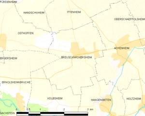
Breuschwickersheim
- commune in Bas-Rhin, France
- Country:
- Postal Code: 67112
- Coordinates: 48° 34' 47" N, 7° 36' 6" E
- GPS tracks (wikiloc): [Link]
- Area: 5.06 sq km
- Population: 1259


Hangenbieten
- commune in Bas-Rhin, France
- Country:
- Postal Code: 67980
- Coordinates: 48° 33' 33" N, 7° 36' 50" E
- GPS tracks (wikiloc): [Link]
- Area: 4.11 sq km
- Population: 1511
- Web site: [Link]

Ernolsheim-Bruche
- commune in Bas-Rhin, France
- Country:
- Postal Code: 67120
- Coordinates: 48° 33' 50" N, 7° 33' 56" E
- GPS tracks (wikiloc): [Link]
- Area: 6.59 sq km
- Population: 1826


Duppigheim
- commune in Bas-Rhin, France
- Country:
- Postal Code: 67120
- Coordinates: 48° 31' 43" N, 7° 35' 37" E
- GPS tracks (wikiloc): [Link]
- Area: 7.38 sq km
- Population: 1576
- Web site: [Link]