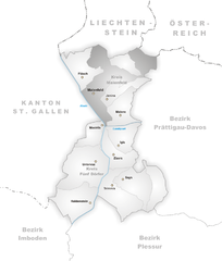
Maienfeld (Kreis Maienfeld)

- subdistrict in the canton of Graubünden, Switzerland
 Hiking in Maienfeld
Kreis Maienfeld, located in the beautiful canton of Graubünden in Switzerland, offers stunning landscapes and a variety of hiking opportunities suitable for all levels of hikers. Here are some highlights and tips for hiking in this picturesque region:
Scenic Trails
-
Heidiland Region: The area is famously associated with the story of Heidi. There are several trails that take you through the idyllic landscapes of the Heidiland region, offering views of rolling hills, alpine meadows, and charming villages.
-
Hiking to the Ruins of Rietberg Castle: This trail takes you up to the ruins of an ancient castle, providing a mix of history and breathtaking views over the valley.
-
Fläsch to Maienfeld: A beautiful trail connecting the two towns, this hike offers views of vineyards and the surrounding mountains. It’s a relatively easy walk suitable for families.
-
Bergwanderung in the Rhein Valley: Enjoy the stunning views of the Rhine River and the surrounding mountains. There are a number of variations in this area, with trails ranging from easy to challenging.
Tips for Hiking in Kreis Maienfeld
-
Trail Information: Make sure to check local signage for trail difficulty levels and conditions. The Swiss Hiking Association also provides excellent resources.
-
Weather Preparedness: Weather in the Alps can change rapidly. Be sure to check the forecast and dress in layers to accommodate temperature changes.
-
Safety Considerations: Stay on marked trails, carry enough water and snacks, and let someone know your itinerary if you’re hiking alone.
-
Wildlife Awareness: As with many alpine areas, you may encounter local wildlife. Respect their space and avoid feeding them.
-
Local Amenities: The region has several charming accommodations and restaurants, making it a great place for multi-day hiking trips.
Best Times to Hike
The best months for hiking in Kreis Maienfeld are typically late spring through early autumn (May to October). Trails in higher elevations may have snow until late spring, so always check trail conditions before heading out.
With its combination of natural beauty, cultural heritage, and a variety of hiking trails, Kreis Maienfeld is a fantastic destination for both beginner and experienced hikers. Whether you're looking for a leisurely walk through vineyards or a challenging mountain hike, you’ll find something that suits your needs here.
- Country:

- Coordinates: 46° 59' 53" N, 9° 32' 45" E


- GPS tracks (wikiloc): [Link]
- Wikidata storage: Wikidata: Q667525
- Wikipedia Commons Category: [Link]
- HDS ID: [15287]
Includes regions:
Maienfeld
- municipality in Switzerland
Hiking in Maienfeld
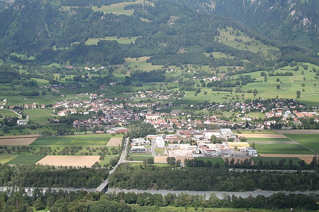
Maienfeld, located in the canton of Graubünden in Switzerland, is a picturesque village famous for its stunning landscapes and wine production, particularly its Bündner wine. The area offers a variety of hiking trails that cater to different skill levels, providing hikers with breathtaking views of the surrounding Alps, charming vineyards, and lush meadows....
- Country:
- Postal Code: 7304
- Local Dialing Code: 081
- Licence Plate Code: GR
- Coordinates: 47° 0' 28" N, 9° 31' 51" E
- GPS tracks (wikiloc): [Link]
- AboveSeaLevel: 1469 м m
- Area: 32.33 sq km
- Population: 2860
- Web site: [Link]


Fläsch
- municipality in the district of Landquart in the Swiss canton of Graubünden
Hiking in Fläsch
Fläsch is a charming village located in the Bündner Herrschaft region of Switzerland, known for its stunning natural landscapes and excellent hiking opportunities. The area around Fläsch features a mix of vineyards, forests, and panoramic mountain views, making it an ideal destination for both casual walkers and experienced hikers....
- Country:
- Postal Code: 7306
- Local Dialing Code: 081
- Licence Plate Code: GR
- Coordinates: 47° 2' 23" N, 9° 31' 59" E
- GPS tracks (wikiloc): [Link]
- AboveSeaLevel: 528 м m
- Area: 19.94 sq km
- Population: 774
- Web site: [Link]


Jenins
- municipality in Switzerland
Hiking in Jenins
Jenins, a scenic village located in the Swiss canton of Graubünden, is an excellent destination for hiking enthusiasts. Nestled in the Rhine valley, Jenins offers a mix of picturesque landscapes, vineyards, and access to diverse hiking trails suitable for various skill levels. Here are some highlights and recommendations for hiking in Jenins:...
- Country:
- Postal Code: 7307
- Local Dialing Code: 081
- Licence Plate Code: GR
- Coordinates: 46° 59' 59" N, 9° 33' 0" E
- GPS tracks (wikiloc): [Link]
- AboveSeaLevel: 1425 м m
- Area: 10.54 sq km
- Population: 896
- Web site: [Link]

Malans
- municipality in Graubünden, Switzerland
Hiking in Malans
Malans is a picturesque village located in the canton of Graubünden in Switzerland, surrounded by stunning alpine scenery and offering an array of hiking opportunities. Here are some highlights related to hiking in and around Malans:...
- Country:
- Postal Code: 7208
- Local Dialing Code: 081
- Licence Plate Code: GR
- Coordinates: 46° 58' 55" N, 9° 34' 34" E
- GPS tracks (wikiloc): [Link]
- AboveSeaLevel: 807 м m
- Area: 11.40 sq km
- Population: 2341
- Web site: [Link]