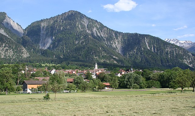
Maienfeld (Maienfeld)

- municipality in Switzerland
 Hiking in Maienfeld
Maienfeld, located in the canton of Graubünden in Switzerland, is a picturesque village famous for its stunning landscapes and wine production, particularly its Bündner wine. The area offers a variety of hiking trails that cater to different skill levels, providing hikers with breathtaking views of the surrounding Alps, charming vineyards, and lush meadows.
Popular Hiking Trails in Maienfeld:
-
Heidi Trail: This trail follows the paths associated with the beloved children's book character Heidi. It offers scenic views of the Rhine Valley, delightful alpine landscapes, and a glimpse into the locales that inspired the Heidi story.
-
Maienfeld Wine Trail: A leisurely hike through the vineyards, where you can learn about local winemaking and enjoy the beautiful scenery of rolling hills covered in grapevines. It’s an excellent choice for those who enjoy a combination of nature and gastronomy.
-
Rheinschlucht (Ruinaulta): A bit further afield, this hike takes you to the impressive Rhine Gorge, known as the "Grand Canyon of Switzerland." You can reach viewpoints that offer spectacular vistas of the river and cliffs, making it a memorable day hike.
-
Greina Plateau: For more experienced hikers, this area offers diverse alpine terrain and stunning panoramas. It's a bit challenging, but the views are well worth the effort.
Tips for Hiking in Maienfeld:
- Best Time to Visit: The best time for hiking in Maienfeld is typically from late spring to early autumn (May to October) when the weather is milder and the trails are accessible.
- Trail Difficulty: Check the trail difficulty levels and be honest about your fitness level. Some trails may be more challenging than they appear.
- Gear Up Properly: Make sure to wear appropriate hiking shoes, weather-resistant clothing, and bring plenty of water and snacks.
- Stay on Marked Paths: To protect the local flora and fauna, it's important to stick to marked trails.
- Local Maps and Guides: Consider grabbing a local hiking map or joining a guided hike to learn more about the area.
Facilities and Accommodations:
Maienfeld offers various options for accommodations, including hotels, guesthouses, and holiday apartments. After a long day of hiking, enjoy some local cuisine in one of the village’s restaurants, and don’t forget to sample some of the renowned Swiss wines!
With its unique combination of natural beauty and cultural heritage, hiking in Maienfeld can provide an enriching experience for all avid outdoor enthusiasts.
- Country:

- Postal Code: 7304
- Local Dialing Code: 081
- Licence Plate Code: GR
- Coordinates: 47° 0' 28" N, 9° 31' 51" E


- GPS tracks (wikiloc): [Link]
- AboveSeaLevel: 1469 м m
- Area: 32.33 sq km
- Population: 2860
- Web site: http://www.maienfeld.ch
- Wikipedia en: wiki(en)
- Wikipedia: wiki(de)
- Wikidata storage: Wikidata: Q64178
- Wikipedia Commons Category: [Link]
- Freebase ID: [/m/026fd8y]
- GeoNames ID: Alt: [7286419]
- VIAF ID: Alt: [136051001]
- OSM relation ID: [1684110]
- GND ID: Alt: [4037087-2]
- archINFORM location ID: [11430]
- Library of Congress authority ID: Alt: [n81061668]
- WOEID: [783233]
- HDS ID: [1606]
- Swiss municipality code: [3953]
- Digital Atlas of the Roman Empire ID: [1942]
- Lexicon istoric retic ID: [1909]
Shares border with regions:

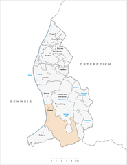
Triesen
- municipality of Liechtenstein
Hiking in Triesen
Triesen, a charming municipality located in Liechtenstein, offers some wonderful hiking opportunities for outdoor enthusiasts. Nestled in the Rhine Valley, surrounded by scenic landscapes and the backdrop of the Alps, Triesen presents a variety of hiking trails suitable for different skill levels....
- Country:

- Postal Code: 9495
- Local Dialing Code: 7002
- Coordinates: 47° 6' 0" N, 9° 31' 0" E
- GPS tracks (wikiloc): [Link]
- AboveSeaLevel: 512 м m
- Area: 26.4 sq km
- Web site: [Link]


Schaan
- municipality of Liechtenstein
Hiking in Schaan
Schaan, located in Liechtenstein, is a great destination for hiking enthusiasts. It offers a picturesque landscape and access to various trails that cater to different skill levels. Here are some details about hiking in and around Schaan:...
- Country:
- Postal Code: 9494
- Local Dialing Code: 7005
- Coordinates: 47° 10' 0" N, 9° 31' 0" E
- GPS tracks (wikiloc): [Link]
- AboveSeaLevel: 450 м m
- Area: 26.8 sq km
- Population: 5959
- Web site: [Link]


Balzers
- municipality of Liechtenstein
Hiking in Balzers
Balzers is a beautiful municipality in Liechtenstein, known for its scenic landscapes, historic sites, and outdoor activities, including hiking. Situated in the Rhine Valley, Balzers offers a range of hiking trails suitable for all skill levels, from leisurely walks to more challenging hikes....
- Country:
- Postal Code: 9496
- Local Dialing Code: 7003
- Coordinates: 47° 4' 0" N, 9° 30' 0" E
- GPS tracks (wikiloc): [Link]
- AboveSeaLevel: 472 м m
- Area: 19.6 sq km
- Population: 4583
- Web site: [Link]


Seewis im Prättigau
- municipality in Switzerland
Hiking in Seewis im Prättigau
Seewis im Prättigau is a charming village located in the Prättigau region of Switzerland, nestled between stunning mountains and picturesque landscapes. Hiking here offers a variety of trails suited for different skill levels, from leisurely walks to more challenging treks, all providing breathtaking views of the surrounding Alpine scenery....
- Country:
- Postal Code: 7212
- Local Dialing Code: 081
- Licence Plate Code: GR
- Coordinates: 46° 59' 25" N, 9° 38' 15" E
- GPS tracks (wikiloc): [Link]
- AboveSeaLevel: 937 м m
- Area: 49.63 sq km
- Population: 1381
- Web site: [Link]


Fläsch
- municipality in the district of Landquart in the Swiss canton of Graubünden
Hiking in Fläsch
Fläsch is a charming village located in the Bündner Herrschaft region of Switzerland, known for its stunning natural landscapes and excellent hiking opportunities. The area around Fläsch features a mix of vineyards, forests, and panoramic mountain views, making it an ideal destination for both casual walkers and experienced hikers....
- Country:
- Postal Code: 7306
- Local Dialing Code: 081
- Licence Plate Code: GR
- Coordinates: 47° 2' 23" N, 9° 31' 59" E
- GPS tracks (wikiloc): [Link]
- AboveSeaLevel: 528 м m
- Area: 19.94 sq km
- Population: 774
- Web site: [Link]


Jenins
- municipality in Switzerland
Hiking in Jenins
Jenins, a scenic village located in the Swiss canton of Graubünden, is an excellent destination for hiking enthusiasts. Nestled in the Rhine valley, Jenins offers a mix of picturesque landscapes, vineyards, and access to diverse hiking trails suitable for various skill levels. Here are some highlights and recommendations for hiking in Jenins:...
- Country:
- Postal Code: 7307
- Local Dialing Code: 081
- Licence Plate Code: GR
- Coordinates: 46° 59' 59" N, 9° 33' 0" E
- GPS tracks (wikiloc): [Link]
- AboveSeaLevel: 1425 м m
- Area: 10.54 sq km
- Population: 896
- Web site: [Link]

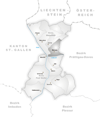
Malans
- municipality in Graubünden, Switzerland
Hiking in Malans
Malans is a picturesque village located in the canton of Graubünden in Switzerland, surrounded by stunning alpine scenery and offering an array of hiking opportunities. Here are some highlights related to hiking in and around Malans:...
- Country:
- Postal Code: 7208
- Local Dialing Code: 081
- Licence Plate Code: GR
- Coordinates: 46° 58' 55" N, 9° 34' 34" E
- GPS tracks (wikiloc): [Link]
- AboveSeaLevel: 807 м m
- Area: 11.40 sq km
- Population: 2341
- Web site: [Link]

Zizers
- municipality in Switzerland
Hiking in Zizers
Zizers, located in the Canton of Graubünden in Switzerland, is a beautiful destination for hiking enthusiasts. The region boasts stunning landscapes, offering a mix of lush valleys, alpine meadows, and impressive mountain vistas. Here are some highlights and tips for hiking in and around Zizers:...
- Country:
- Postal Code: 7205
- Local Dialing Code: 081
- Licence Plate Code: GR
- Coordinates: 46° 56' 11" N, 9° 34' 15" E
- GPS tracks (wikiloc): [Link]
- AboveSeaLevel: 606 м m
- Area: 11.01 sq km
- Population: 3443
- Web site: [Link]
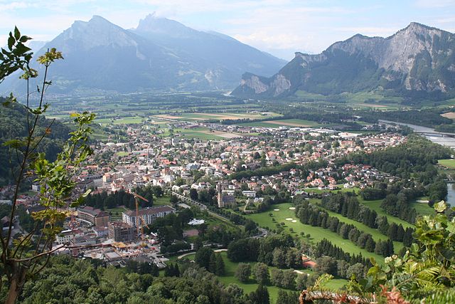

Bad Ragaz
- municipality in Switzerland
Hiking in Bad Ragaz
Bad Ragaz, located in the Swiss Rhine Valley near the foothills of the Alps, is a fantastic destination for hiking enthusiasts. Known for its thermal baths and wellness resorts, the area also offers beautiful landscapes and a variety of hiking trails suitable for different skill levels. Here are some highlights for hiking in Bad Ragaz:...
- Country:
- Postal Code: 7310
- Local Dialing Code: 081
- Licence Plate Code: SG
- Coordinates: 46° 59' 59" N, 9° 30' 0" E
- GPS tracks (wikiloc): [Link]
- AboveSeaLevel: 516 м m
- Area: 25.37 sq km
- Population: 5923
- Web site: [Link]