
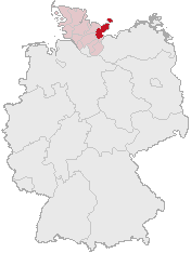
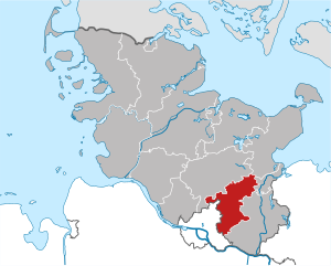
Lübeck (Lübeck)


- city in Schleswig-Holstein, Germany
 Hiking in Lübeck
Lübeck, located in northern Germany, is known for its rich medieval history, beautiful architecture, and proximity to the scenic Baltic Sea. While it may not be primarily recognized as a hiking destination, there are still several opportunities for outdoor enthusiasts to enjoy nature and explore the region through hiking.
Hiking Opportunities Around Lübeck:
-
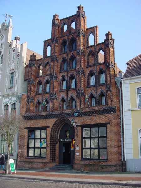
Lübeck's Old Town: While not a traditional hike, walking through Lübeck's UNESCO World Heritage Old Town can be a delightful experience. You can explore cobblestone streets, historical buildings, and landmarks like St. Mary's Church and the Holstentor gate.
-
Wakenitz Nature Reserve: Just outside Lübeck, the Wakenitz River flows through a beautiful nature reserve. There are several trails along the riverbanks where you can hike, enjoy bird watching, and experience the tranquil environment.
-
Travemünde: A coastal district of Lübeck, Travemünde offers a lovely beach and walking paths along the shore. The promenade along the Baltic Sea is perfect for a leisurely hike with stunning water views.
-
Lauenburg Heath: Located a short drive from Lübeck, this area offers more rugged terrain for hiking. You’ll find various trails winding through forests, heathland, and along the Elbe River.
-
Around Bungsberg: About an hour from Lübeck, Bungsberg is the highest point in Holstein (approx. 168 m) and has trails with great views over the area. It's ideal for moderate hiking and is surrounded by the rolling hills of the Holstein Switzerland region.
Tips for Hiking in Lübeck:
- Stay Hydrated: Carry enough water, especially during longer hikes.
- Check the Weather: The weather can change quickly in northern Germany, so be prepared with appropriate clothing.
- Leave No Trace: Respect nature by sticking to marked trails and taking all rubbish with you.
- Local Maps: Consider using local hiking maps or apps to navigate the trails more effectively.
Conclusion
While Lübeck may not have extensive hiking trails like more mountainous regions, its beautiful surroundings, historical sights, and nearby nature reserves provide plenty of opportunities for enjoyable walks and hikes. Whether it's through the city’s historic streets or along the scenic rivers and beaches, there's something for every outdoor lover.
- Country:

- Postal Code: 23552–23570
- Local Dialing Code: 451; 4508; 4502
- Licence Plate Code: HL
- Coordinates: 53° 52' 11" N, 10° 41' 11" E


- GPS tracks (wikiloc): [Link]
- AboveSeaLevel: 13 м m
- Area: 214.21 sq km
- Population: 216709
- Web site: http://www.luebeck.de
- Wikipedia en: wiki(en)
- Wikipedia: wiki(de)
- Wikidata storage: Wikidata: Q2843
- Wikipedia Commons Gallery: [Link]
- Wikipedia Commons Category: [Link]
- Wikipedia Commons Maps Category: [Link]
- Freebase ID: [/m/04hhb]
- GeoNames ID: Alt: [2875601]
- BnF ID: [12271049t]
- VIAF ID: Alt: [312802961]
- OSM relation ID: [62463]
- GND ID: Alt: [4036483-5]
- archINFORM location ID: [470]
- Library of Congress authority ID: Alt: [n81108828]
- MusicBrainz area ID: [7be2e8c7-2264-43e4-ac57-0bdce42022c1]
- Quora topic ID: [Lübeck-Germany]
- TGN ID: [7012327]
- SUDOC authorities ID: [031509258]
- Encyclopædia Britannica Online ID: [place/Lubeck]
- Encyclopædia Universalis ID: [lubeck]
- Historical Gazetteer (GOV) ID: [LUBECKJO53IU]
- EMLO location ID: [e7800e74-36e0-4b31-abc4-b5cf4552832f]
- Facebook Places ID: [113746281972409]
- Great Russian Encyclopedia Online ID: [2161423]
- National Library of Israel ID: [000987586]
- NUTS code: [DEF03]
- YSO ID: [105988]
- Nomisma ID: [luebeck]
- Klexikon article ID: [Lübeck]
- Global Anabaptist Mennonite Encyclopedia Online ID: [Lübeck (Schleswig-Holstein, Germany)]
- Store norske leksikon ID: [Lübeck]
- Image Archive, Herder Institute: [Q2843]
- German municipality key: 01003000
- US National Archives Identifier: 10045562
- German district key: 01003
Includes regions:
St. Jürgen
- quarter of Lübeck, Germany
Hiking in St. Jürgen
Lübeck-St. Jürgen is a district in the city of Lübeck, Germany, known for its blend of urban and natural environments. While Lübeck itself is more famous for its historical architecture and UNESCO World Heritage Sites, the surrounding areas, including St. Jürgen, offer opportunities for hiking and enjoying nature....
- Country:
- Local Dialing Code: 0451
- Coordinates: 53° 51' 19" N, 10° 41' 50" E
- GPS tracks (wikiloc): [Link]
- Area: 61.9 sq km
Lübeck-Schlutup
- human settlement in Germany
Hiking in Lübeck-Schlutup
Lübeck-Schlutup is a picturesque area located on the outskirts of Lübeck, Germany. Although it is not as well-known for hiking as some of the more mountainous regions of Germany, it offers several opportunities for outdoor activities, including leisurely hikes through scenic landscapes....
- Country:
- Local Dialing Code: 0451
- Coordinates: 53° 53' 28" N, 10° 47' 52" E
- GPS tracks (wikiloc): [Link]
- AboveSeaLevel: 15 м m
Buntekuh
- human settlement in Germany
Hiking in Buntekuh
Lübeck-Buntekuh, a lovely district of Lübeck in northern Germany, is not primarily known for extensive hiking trails compared to more mountainous regions; however, it does offer some enjoyable walking and hiking opportunities. Here are some tips and information for hiking in and around Lübeck-Buntekuh:...
- Country:
- Postal Code: 23556
- Local Dialing Code: 0451
- Coordinates: 53° 51' 58" N, 10° 38' 56" E
- GPS tracks (wikiloc): [Link]
- Area: 4.9 sq km

Lübeck's Old City
- human settlement in Germany
Hiking in Lübeck's Old City
Lübecker Altstadt, or Lübeck's Old Town, is not typically associated with hiking in the traditional sense, as it is more of a historic and architectural exploration area. However, you can certainly enjoy a leisurely walking tour that offers the experience of hiking-like scenery amidst the rich history and beautiful architecture of Lübeck....
- Country:
- Coordinates: 53° 52' 5" N, 10° 41' 10" E
- GPS tracks (wikiloc): [Link]
Kücknitz
- quarter of Lübeck, Germany
Hiking in Kücknitz
Lübeck-Kücknitz is a charming area located on the outskirts of Lübeck, in northern Germany, and offers a variety of hiking opportunities for nature enthusiasts. Here are some highlights and tips for hiking in this region:...
- Country:
- Postal Code: 23569
- Local Dialing Code: 0451
- Coordinates: 53° 54' 50" N, 10° 48' 0" E
- GPS tracks (wikiloc): [Link]
- Area: 24.6 sq km
Lübeck-St. Gertrud
- human settlement in Germany
Hiking in Lübeck-St. Gertrud
Lübeck-St. Gertrud is a scenic district located in Lübeck, Germany, known for its beautiful landscapes, historical sites, and serene walking paths. While Lübeck is more famous for its UNESCO-listed Old Town, St. Gertrud offers a different experience with its combination of nature and local charm....
- Country:
- Local Dialing Code: 0451
- Coordinates: 53° 52' 12" N, 10° 43' 12" E
- GPS tracks (wikiloc): [Link]
- Area: 26.5 sq km


Lübeck-Moisling
- human settlement in Germany
Hiking in Lübeck-Moisling
Lübeck-Moisling, located on the outskirts of the historic city of Lübeck in Germany, offers several pleasant walking and hiking opportunities for outdoor enthusiasts. While Moisling itself is predominantly a residential area, it has access to green spaces and trails that can provide an enjoyable experience for hikers....
- Country:
- Local Dialing Code: 0451
- Coordinates: 53° 50' 28" N, 10° 37' 57" E
- GPS tracks (wikiloc): [Link]
- AboveSeaLevel: 11 м m
Lübeck-St. Lorenz Nord
Hiking in Lübeck-St. Lorenz Nord
Lübeck-St. Lorenz Nord is a district in Lübeck, Germany, known for its charming landscapes and proximity to nature, making it an interesting area for hiking enthusiasts. While Lübeck itself is more famous for its historical architecture and the UNESCO World Heritage sites of the Old Town, the surrounding areas, including St. Lorenz Nord, offer various opportunities for outdoor activities....
- Country:
- Area: 27.9 sq km
- Population: 41915
Lübeck-St. Lorenz Süd
Hiking in Lübeck-St. Lorenz Süd
Lübeck-St. Lorenz Süd is a district in Lübeck, Germany, located in the northern part of the country. While it's primarily urban and offers a mix of residential areas and local amenities, there are some outdoor spaces that can provide opportunities for light hiking and walking....
- Country:
- Area: 2.9 sq km
- Population: 15618

Travemünde
- seaport and borough of Lübeck, Schleswig-Holstein, Germany
Hiking in Travemünde
Travemünde, a district of Lübeck in northern Germany, is more well-known for its beautiful beach and scenic waterfront rather than traditional hiking trails. However, the surrounding area offers some lovely hiking opportunities, particularly along the Baltic Sea coastline and through nearby nature reserves....
- Country:
- Postal Code: 23570
- Local Dialing Code: 04502
- Coordinates: 53° 57' 38" N, 10° 52' 9" E
- GPS tracks (wikiloc): [Link]
- AboveSeaLevel: 3 м m
- Population: 13456
- Web site: [Link]
Shares border with regions:

Nordwestmecklenburg District
- district in Germany
Hiking in Nordwestmecklenburg District
Nordwestmecklenburg, located in northern Germany, is a beautiful area characterized by its diverse landscapes, including forests, lakes, and access to the Baltic Sea. It's perfect for hiking enthusiasts looking for scenic routes and a peaceful environment. Here’s what you need to know about hiking in this region:...
- Country:
- Capital: Wismar
- Licence Plate Code: (HWI); NWM; WIS; GVM; GDB
- Coordinates: 53° 49' 48" N, 11° 10' 12" E
- GPS tracks (wikiloc): [Link]
- AboveSeaLevel: 37 м m
- Area: 2117.00 sq km
- Population: 155424
- Web site: [Link]

Ostholstein
- German district
Hiking in Ostholstein
Ostholstein, located in the northern part of Germany in Schleswig-Holstein, is a beautiful area known for its diverse landscapes, coastal scenery, and rich cultural history. Here are some highlights and tips for hiking in Ostholstein:...
- Country:
- Licence Plate Code: OH
- Coordinates: 54° 10' 12" N, 10° 49' 48" E
- GPS tracks (wikiloc): [Link]
- AboveSeaLevel: 46 м m
- Web site: [Link]
Herzogtum Lauenburg
- district of Germany
Hiking in Herzogtum Lauenburg
Herzogtum Lauenburg is a picturesque region in northern Germany, known for its scenic landscapes, rich history, and charming towns. If you're considering hiking in this area, you'll find a variety of trails and natural attractions that cater to different skill levels. Here are some highlights and tips for hiking in Herzogtum Lauenburg:...
- Country:
- Licence Plate Code: RZ
- Coordinates: 53° 35' 0" N, 10° 40' 0" E
- GPS tracks (wikiloc): [Link]
- AboveSeaLevel: 35 м m
- Area: 1262.97 sq km
- Population: 192999
- Web site: [Link]

Stormarn
- German district
Hiking in Stormarn
Stormarn is a district in the federal state of Schleswig-Holstein, Germany, known for its beautiful landscapes, lush forests, and charming villages. Hiking in this area offers a variety of trails suitable for all levels of experience, catering to both casual walkers and avid trekkers. Here are some highlights and tips for hiking in Stormarn:...
- Country:
- Licence Plate Code: OD
- Coordinates: 53° 45' 0" N, 10° 19' 48" E
- GPS tracks (wikiloc): [Link]
- AboveSeaLevel: 34 м m
- Area: 766.33 sq km
- Population: 236705
- Web site: [Link]