La Chapelle-Blanche (La Chapelle-Blanche)

- commune in Savoie, France
 Hiking in La Chapelle-Blanche
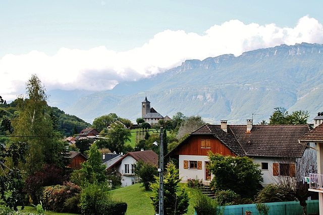
La Chapelle-Blanche is a charming commune located in the Savoie department in southeastern France. Nestled in the French Alps, it offers a unique hiking experience with stunning mountain views, lush landscapes, and a rich natural environment.
Hiking Opportunities
-
Scenic Routes: The area around La Chapelle-Blanche features several hiking trails that vary in difficulty, making it suitable for both beginners and experienced hikers. Trails range from leisurely walks through alpine meadows to more strenuous hikes that provide spectacular views of the surrounding mountains.
-
Access to Nature Reserves: The region is close to natural reserves and protected areas, which often have designated hiking paths. These spots are perfect for observing local wildlife and enjoying the diversity of alpine flora.
-
Mont Granier and Surroundings: Nearby Mont Granier offers more challenging hikes. The summit provides breathtaking panoramas of the valley and the surrounding peaks, making it a worthwhile destination for seasoned hikers.
-
Local Culture and History: Many trails can lead you through quaint villages and historical sites, allowing for cultural exploration alongside your hiking. Look out for traditional mountain architecture and perhaps stop at local eateries for some authentic Savoyard cuisine.
Tips for Hiking in La Chapelle-Blanche
- Check Trail Conditions: Before setting out, check the trail conditions, as some paths may be affected by weather or seasonal changes.
- Gear Up: Wear appropriate hiking shoes and carry sufficient water and snacks. Depending on the season, you may need gear for varying weather conditions.
- Wildlife Awareness: Be mindful of local wildlife. While encounters are typically safe, it’s important to respect their habitat.
- Leave No Trace: Follow Leave No Trace principles to help preserve the natural beauty of the region.
Best Times to Hike
- Spring and Summer: These seasons are ideal for hiking, with pleasant temperatures and blooming flowers. Summer typically offers the best weather for extensive treks.
- Autumn: Fall brings stunning foliage; however, be prepared for cooler temperatures and shorter days.
- Winter: While hiking in winter is possible, it often requires snowshoeing or other winter gear, and trails can be quite different in terms of accessibility.
Whether you are looking for a casual stroll or a challenging hike, La Chapelle-Blanche has much to offer for nature lovers and outdoor enthusiasts. Always plan accordingly and enjoy the serenity of the magnificent Savoie Alps!
- Country:

- Postal Code: 73110
- Coordinates: 45° 26' 52" N, 6° 4' 20" E


- GPS tracks (wikiloc): [Link]
- Area: 4.13 sq km
- Population: 556
- Wikipedia en: wiki(en)
- Wikipedia: wiki(fr)
- Wikidata storage: Wikidata: Q1164411
- Wikipedia Commons Category: [Link]
- Freebase ID: [/m/03npfbj]
- GeoNames ID: Alt: [6457065]
- SIREN number: [217300755]
- BnF ID: [15274009q]
- VIAF ID: Alt: [139948506]
- Library of Congress authority ID: Alt: [no2009062662]
- INSEE municipality code: 73075
Shares border with regions:


Détrier
- commune in Savoie, France
Hiking in Détrier
Détrier is a lesser-known area but offers beautiful landscapes and a variety of hiking options for outdoor enthusiasts. Here are some key points to consider if you're thinking about hiking in the Détrier area:...
- Country:
- Postal Code: 73110
- Coordinates: 45° 26' 43" N, 6° 5' 55" E
- GPS tracks (wikiloc): [Link]
- Area: 2.25 sq km
- Population: 422
Villaroux
- commune in Savoie, France
Hiking in Villaroux
Villaroux is a beautiful area for hiking, situated in the French Alps. It's known for its breathtaking landscapes, diverse flora and fauna, and a variety of trails that cater to different skill levels. Here are some details you might find useful if you're considering hiking in Villaroux:...
- Country:
- Postal Code: 73110
- Coordinates: 45° 27' 29" N, 6° 4' 30" E
- GPS tracks (wikiloc): [Link]
- Area: 3.09 sq km
- Population: 216

Les Mollettes
- commune in Savoie, France
Hiking in Les Mollettes
Les Mollettes is a beautiful hiking destination located in the French Alps, specifically in the Savoie region. The area is known for its stunning natural landscapes, diverse wildlife, and a variety of hiking trails suitable for all levels of experience....
- Country:
- Postal Code: 73800
- Coordinates: 45° 27' 39" N, 6° 3' 15" E
- GPS tracks (wikiloc): [Link]
- Area: 5.47 sq km
- Population: 798
- Web site: [Link]

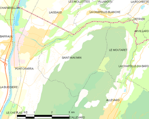
Saint-Maximin
- commune in Isère, France
Hiking in Saint-Maximin
Saint-Maximin, located in the Isère department in the Auvergne-Rhône-Alpes region of France, offers a range of beautiful hiking opportunities. Surrounded by the picturesque landscape of the Vercors and Chartreuse mountain ranges, it provides hikers with stunning views, diverse terrain, and a variety of trails suitable for different skill levels....
- Country:
- Postal Code: 38530
- Coordinates: 45° 25' 35" N, 6° 2' 16" E
- GPS tracks (wikiloc): [Link]
- Area: 10.35 sq km
- Population: 643
- Web site: [Link]


Le Moutaret
- commune in Isère, France
Hiking in Le Moutaret
Le Moutaret is located in the French Alps, within the vicinity of the Écrins National Park. This region is known for its stunning landscapes, diverse flora and fauna, and a network of hiking trails that cater to various skill levels. Here are some key points about hiking in Le Moutaret:...
- Country:
- Postal Code: 38580
- Coordinates: 45° 25' 55" N, 6° 5' 19" E
- GPS tracks (wikiloc): [Link]
- Area: 5.29 sq km
- Population: 253
- Web site: [Link]


Laissaud
- commune in Savoie, France
Hiking in Laissaud
Laissaud is a beautiful area located in the French Alps, known for its stunning scenery and diverse hiking opportunities. The region offers a variety of trails suitable for different skill levels, from gentle walks to more challenging treks. Here's some information to help you plan your hiking experience in Laissaud:...
- Country:
- Postal Code: 73800
- Coordinates: 45° 26' 49" N, 6° 2' 13" E
- GPS tracks (wikiloc): [Link]
- Area: 6.57 sq km
- Population: 660