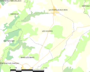
La Chapelle-aux-Bois (La Chapelle-aux-Bois)

- commune in Vosges, France
- Country:

- Postal Code: 88240
- Coordinates: 48° 2' 13" N, 6° 19' 56" E


- GPS tracks (wikiloc): [Link]
- Area: 30.65 sq km
- Population: 666
- Web site: http://www.valdevoge.com/php_creations/valdevoge/cms/index.php?option=com_content&task=section&id=19&Itemid=110
- Wikipedia en: wiki(en)
- Wikipedia: wiki(fr)
- Wikidata storage: Wikidata: Q837694
- Wikipedia Commons Category: [Link]
- Freebase ID: [/m/03qgwng]
- Freebase ID: [/m/03qgwng]
- GeoNames ID: Alt: [6457176]
- GeoNames ID: Alt: [6457176]
- SIREN number: [218800886]
- SIREN number: [218800886]
- BnF ID: [152790166]
- BnF ID: [152790166]
- INSEE municipality code: 88088
- INSEE municipality code: 88088
Shares border with regions:

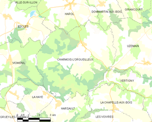
Charmois-l'Orgueilleux
- commune in Vosges, France
- Country:
- Postal Code: 88270
- Coordinates: 48° 6' 12" N, 6° 16' 14" E
- GPS tracks (wikiloc): [Link]
- Area: 35.92 sq km
- Population: 591
- Web site: [Link]

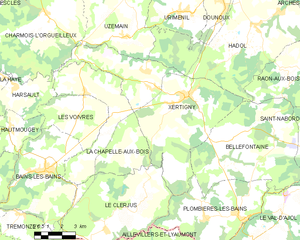
Xertigny
- commune in Vosges, France
- Country:
- Postal Code: 88220
- Coordinates: 48° 2' 44" N, 6° 24' 22" E
- GPS tracks (wikiloc): [Link]
- Area: 50.25 sq km
- Population: 2631
- Web site: [Link]


Le Clerjus
- commune in Vosges, France
- Country:
- Postal Code: 88240
- Coordinates: 47° 57' 34" N, 6° 19' 17" E
- GPS tracks (wikiloc): [Link]
- Area: 32.93 sq km
- Population: 561


Harsault
- former commune in Vosges, France
- Country:
- Postal Code: 88240
- Coordinates: 48° 3' 25" N, 6° 14' 16" E
- GPS tracks (wikiloc): [Link]
- Area: 10.85 sq km
- Population: 358


Bains-les-Bains
- former commune in Vosges, France
- Country:
- Postal Code: 88240
- Coordinates: 48° 0' 9" N, 6° 15' 49" E
- GPS tracks (wikiloc): [Link]
- AboveSeaLevel: 325 м m
- Area: 25.37 sq km
- Population: 1208
- Web site: [Link]

Les Voivres
- commune in Vosges, France
- Country:
- Postal Code: 88240
- Coordinates: 48° 1' 52" N, 6° 17' 41" E
- GPS tracks (wikiloc): [Link]
- Area: 12.81 sq km
- Population: 320