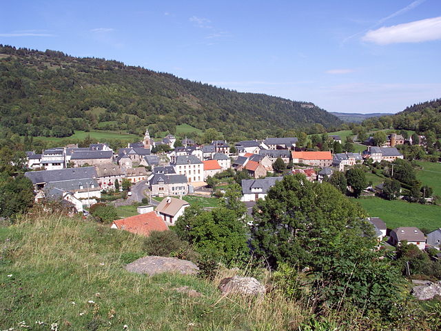
La Chapelle-d'Alagnon (La Chapelle-d'Alagnon)

- commune in Cantal, France
- Country:

- Postal Code: 15300
- Coordinates: 45° 6' 28" N, 2° 53' 47" E


- GPS tracks (wikiloc): [Link]
- Area: 9.2 sq km
- Population: 246
- Wikipedia en: wiki(en)
- Wikipedia: wiki(fr)
- Wikidata storage: Wikidata: Q269369
- Wikipedia Commons Category: [Link]
- Freebase ID: [/m/03mb6_y]
- GeoNames ID: Alt: [6456731]
- SIREN number: [211500418]
- BnF ID: [152482115]
- INSEE municipality code: 15041
Shares border with regions:


Celles
- former commune in Cantal, France
- Country:
- Postal Code: 15170
- Coordinates: 45° 6' 54" N, 2° 57' 15" E
- GPS tracks (wikiloc): [Link]
- Area: 18.35 sq km
- Population: 217


Murat
- former commune in Cantal, France
- Country:
- Postal Code: 15300
- Coordinates: 45° 6' 36" N, 2° 52' 7" E
- GPS tracks (wikiloc): [Link]
- Area: 6.47 sq km
- Population: 1833
Laveissenet
- commune in Cantal, France
- Country:
- Postal Code: 15300
- Coordinates: 45° 4' 54" N, 2° 53' 20" E
- GPS tracks (wikiloc): [Link]
- Area: 10.79 sq km
- Population: 123
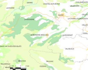
Albepierre-Bredons
- commune in Cantal, France
- Country:
- Postal Code: 15300
- Coordinates: 45° 4' 39" N, 2° 49' 55" E
- GPS tracks (wikiloc): [Link]
- Area: 34.42 sq km
- Population: 243
- Web site: [Link]


Ussel
- commune in Cantal, France
- Country:
- Postal Code: 15300
- Coordinates: 45° 4' 52" N, 2° 56' 8" E
- GPS tracks (wikiloc): [Link]
- Area: 10.34 sq km
- Population: 478


Virargues
- commune in Cantal, France
- Country:
- Postal Code: 15300
- Coordinates: 45° 7' 30" N, 2° 54' 37" E
- GPS tracks (wikiloc): [Link]
- Area: 11.03 sq km
- Population: 133