La Ferté-Imbault (La Ferté-Imbault)

- commune in Loir-et-Cher, France
- Country:

- Postal Code: 41300
- Coordinates: 47° 23' 9" N, 1° 57' 20" E


- GPS tracks (wikiloc): [Link]
- Area: 50.02 sq km
- Population: 978
- Wikipedia en: wiki(en)
- Wikipedia: wiki(fr)
- Wikidata storage: Wikidata: Q1161950
- Wikipedia Commons Category: [Link]
- Freebase ID: [/m/03nw00_]
- GeoNames ID: Alt: [3009488]
- SIREN number: [214100844]
- BnF ID: [152593603]
- INSEE municipality code: 41084
Shares border with regions:


Theillay
- commune in Loir-et-Cher, France
- Country:
- Postal Code: 41300
- Coordinates: 47° 18' 50" N, 2° 2' 25" E
- GPS tracks (wikiloc): [Link]
- Area: 96.38 sq km
- Population: 1308


Selles-Saint-Denis
- commune in Loir-et-Cher, France
- Country:
- Postal Code: 41300
- Coordinates: 47° 23' 9" N, 1° 55' 21" E
- GPS tracks (wikiloc): [Link]
- Area: 50.98 sq km
- Population: 1316
- Web site: [Link]


Saint-Viâtre
- commune in Loir-et-Cher, France
- Country:
- Postal Code: 41210
- Coordinates: 47° 31' 24" N, 1° 56' 0" E
- GPS tracks (wikiloc): [Link]
- Area: 89.79 sq km
- Population: 1236
- Web site: [Link]


Marcilly-en-Gault
- commune in Loir-et-Cher, France
- Country:
- Postal Code: 41210
- Coordinates: 47° 27' 55" N, 1° 52' 25" E
- GPS tracks (wikiloc): [Link]
- Area: 50.31 sq km
- Population: 751

Châtres-sur-Cher
- commune in Loir-et-Cher, France
- Country:
- Postal Code: 41320
- Coordinates: 47° 15' 54" N, 1° 54' 22" E
- GPS tracks (wikiloc): [Link]
- Area: 35.33 sq km
- Population: 1104
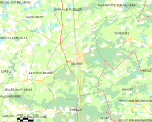
Salbris
- commune in Loir-et-Cher, France
- Country:
- Postal Code: 41300
- Coordinates: 47° 25' 31" N, 2° 3' 7" E
- GPS tracks (wikiloc): [Link]
- Area: 106.61 sq km
- Population: 5356
- Web site: [Link]