Châtres-sur-Cher (Châtres-sur-Cher)

- commune in Loir-et-Cher, France
- Country:

- Postal Code: 41320
- Coordinates: 47° 15' 54" N, 1° 54' 22" E


- GPS tracks (wikiloc): [Link]
- Area: 35.33 sq km
- Population: 1104
- Wikipedia en: wiki(en)
- Wikipedia: wiki(fr)
- Wikidata storage: Wikidata: Q1172578
- Wikipedia Commons Category: [Link]
- Freebase ID: [/m/03nv_d0]
- GeoNames ID: Alt: [3026019]
- SIREN number: [214100448]
- BnF ID: [15259320v]
- archINFORM location ID: [45249]
- PACTOLS thesaurus ID: [pcrtObqQaUrvbN]
- INSEE municipality code: 41044
Shares border with regions:


Langon-sur-Cher
- commune in Loir-et-Cher, France
- Country:
- Postal Code: 41320
- Coordinates: 47° 17' 4" N, 1° 49' 37" E
- GPS tracks (wikiloc): [Link]
- Area: 38.82 sq km
- Population: 813


La Ferté-Imbault
- commune in Loir-et-Cher, France
- Country:
- Postal Code: 41300
- Coordinates: 47° 23' 9" N, 1° 57' 20" E
- GPS tracks (wikiloc): [Link]
- Area: 50.02 sq km
- Population: 978


Theillay
- commune in Loir-et-Cher, France
- Country:
- Postal Code: 41300
- Coordinates: 47° 18' 50" N, 2° 2' 25" E
- GPS tracks (wikiloc): [Link]
- Area: 96.38 sq km
- Population: 1308


Selles-Saint-Denis
- commune in Loir-et-Cher, France
- Country:
- Postal Code: 41300
- Coordinates: 47° 23' 9" N, 1° 55' 21" E
- GPS tracks (wikiloc): [Link]
- Area: 50.98 sq km
- Population: 1316
- Web site: [Link]

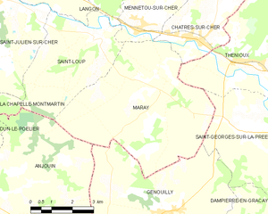
Maray
- commune in Loir-et-Cher, France
- Country:
- Postal Code: 41320
- Coordinates: 47° 14' 50" N, 1° 53' 6" E
- GPS tracks (wikiloc): [Link]
- Area: 27.8 sq km
- Population: 232


Mennetou-sur-Cher
- commune in Loir-et-Cher, France
- Country:
- Postal Code: 41320
- Coordinates: 47° 16' 10" N, 1° 51' 57" E
- GPS tracks (wikiloc): [Link]
- Area: 16.26 sq km
- Population: 902


Thénioux
- commune in Cher, France
- Country:
- Postal Code: 18100
- Coordinates: 47° 15' 23" N, 1° 55' 53" E
- GPS tracks (wikiloc): [Link]
- Area: 18.33 sq km
- Population: 669