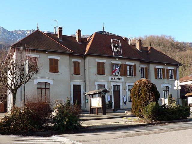
La Flachère (La Flachère)
- commune in Isère, France
La Flachère is a beautiful area located in the French Alps, specifically within the Savoie region. This region is renowned for its stunning landscapes, mountainous terrain, and diverse trails suitable for hikers of all skill levels.
Hiking Trails
- Variety of Trails: La Flachère offers a range of hiking trails that can take you through lush forests, past picturesque lakes, and provide breathtaking views of the surrounding mountains.
- Difficulty Levels: Trails vary from easy walks suitable for families to more challenging routes ideal for experienced hikers. Make sure to choose a path that matches your fitness level.
Notable Hikes
- Les Lacs de Bordon: A popular hike that leads to beautiful alpine lakes, this trail is stunning in both summer and fall, showcasing vibrant colors and wildlife.
- Mont Granier: For those looking for a challenge, this hike offers panoramic views at the summit and is rich in flora and fauna.
Preparing for Your Hike
- Weather Conditions: The alpine weather can change rapidly. Check forecasts before heading out, and bring appropriate clothing for conditions.
- Gear: Wear sturdy hiking boots, carry plenty of water, and pack a map or GPS device. A first-aid kit is also advisable.
- Wildlife Awareness: The region is home to various wildlife. Keep a safe distance if you encounter animals.
Other Activities
In addition to hiking, La Flachère offers opportunities for rock climbing, mountain biking, and winter sports, making it a year-round destination.
Accessibility
Ensure you check if the trails are accessible based on the season, as some routes may be closed during winter or early spring.
Conclusion
Hiking in La Flachère is a fantastic way to immerse yourself in the natural beauty of the French Alps. With the right preparation and respect for the environment, you can enjoy a memorable outdoor adventure!
- Country:

- Postal Code: 38530
- Coordinates: 45° 23' 55" N, 5° 57' 47" E


- GPS tracks (wikiloc): [Link]
- Area: 2.85 sq km
- Population: 479
- Web site: http://laflachere.googlepages.com/home
- Wikipedia en: wiki(en)
- Wikipedia: wiki(fr)
- Wikidata storage: Wikidata: Q1106844
- Wikipedia Commons Category: [Link]
- Freebase ID: [/m/03nvjvt]
- GeoNames ID: Alt: [6455934]
- SIREN number: [213801665]
- BnF ID: [152579879]
- INSEE municipality code: 38166
Shares border with regions:


Sainte-Marie-d'Alloix
- commune in Isère, France
 Hiking in Sainte-Marie-d'Alloix
Sainte-Marie-d'Alloix is a charming village located in the French Alps, particularly well-known for its stunning natural landscapes and hiking opportunities. Here are some key aspects to consider when hiking in and around this area:...
- Country:

- Postal Code: 38660
- Coordinates: 45° 22' 45" N, 5° 57' 59" E


- GPS tracks (wikiloc): [Link]
- Area: 3.04 sq km
- Population: 482


Barraux
- commune in Isère, France
Barraux, a charming village located near Grenoble in the Isère department of France, offers several hiking opportunities that are suitable for different skill levels. The area is characterized by its beautiful natural scenery, including the nearby Chartreuse Mountains, which provide a stunning backdrop for outdoor activities....
- Country:

- Postal Code: 38530
- Coordinates: 45° 26' 4" N, 5° 58' 40" E


- GPS tracks (wikiloc): [Link]
- Area: 11.13 sq km
- Population: 1876
- Web site: [Link]


Saint-Vincent-de-Mercuze
- commune in Isère, France
 Hiking in Saint-Vincent-de-Mercuze
Saint-Vincent-de-Mercuze, located in the Isère department of the Auvergne-Rhône-Alpes region in southeastern France, offers a variety of hiking opportunities amidst beautiful natural landscapes. Here are some highlights of hiking in this area:...
- Country:

- Postal Code: 38660
- Coordinates: 45° 22' 27" N, 5° 56' 59" E


- GPS tracks (wikiloc): [Link]
- Area: 7.85 sq km
- Population: 1481
- Web site: [Link]


La Buissière
- commune in Isère, France
La Buissière is a charming village located in France, often characterized by its scenic landscapes and proximity to nature, making it an excellent location for hiking enthusiasts. While the specific trails in La Buissière may not be widely documented, the surrounding regions typically offer various outdoor activities, including hiking paths that range from easy strolls to more challenging treks....
- Country:

- Postal Code: 38530
- Coordinates: 45° 24' 9" N, 5° 58' 42" E


- GPS tracks (wikiloc): [Link]
- Area: 7.71 sq km
- Population: 672
- Web site: [Link]


Sainte-Marie-du-Mont
- commune in Isère, France
 Hiking in Sainte-Marie-du-Mont
Sainte-Marie-du-Mont is a charming village located in the Isère department of the Auvergne-Rhône-Alpes region in southeastern France. This area is known for its stunning natural landscapes and variety of outdoor activities, making it a great destination for hiking enthusiasts....
- Country:

- Postal Code: 38660
- Coordinates: 45° 24' 22" N, 5° 56' 44" E


- GPS tracks (wikiloc): [Link]
- Area: 23.87 sq km
- Population: 237
- Web site: [Link]
