La Vancelle (La Vancelle)

- commune in Bas-Rhin, France
- Country:

- Postal Code: 67730
- Coordinates: 48° 17' 10" N, 7° 18' 14" E


- GPS tracks (wikiloc): [Link]
- Area: 7.88 sq km
- Population: 406
- Wikipedia en: wiki(en)
- Wikipedia: wiki(fr)
- Wikidata storage: Wikidata: Q22416
- Wikipedia Commons Category: [Link]
- Freebase ID: [/m/03m4ccs]
- Freebase ID: [/m/03m4ccs]
- GeoNames ID: Alt: [3005784]
- GeoNames ID: Alt: [3005784]
- SIREN number: [216705053]
- SIREN number: [216705053]
- BnF ID: [152716476]
- BnF ID: [152716476]
- INSEE municipality code: 67505
- INSEE municipality code: 67505
Shares border with regions:


Lièpvre
- commune in Haut-Rhin, France
- Country:
- Postal Code: 68660
- Coordinates: 48° 16' 20" N, 7° 16' 57" E
- GPS tracks (wikiloc): [Link]
- Area: 12.55 sq km
- Population: 1751

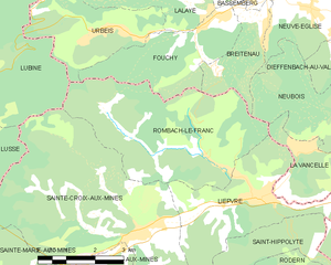
Rombach-le-Franc
- commune in Haut-Rhin, France
- Country:
- Postal Code: 68660
- Coordinates: 48° 17' 3" N, 7° 15' 38" E
- GPS tracks (wikiloc): [Link]
- Area: 17.87 sq km
- Population: 801


Kintzheim
- commune in Bas-Rhin, France
- Country:
- Postal Code: 67600
- Coordinates: 48° 15' 16" N, 7° 23' 48" E
- GPS tracks (wikiloc): [Link]
- Area: 18.78 sq km
- Population: 1612
- Web site: [Link]


Châtenois
- commune in Bas-Rhin, France
- Country:
- Postal Code: 67730
- Coordinates: 48° 16' 19" N, 7° 24' 3" E
- GPS tracks (wikiloc): [Link]
- Area: 14.57 sq km
- Population: 4128


Neubois
- commune in Bas-Rhin, France
- Country:
- Postal Code: 67220
- Coordinates: 48° 18' 23" N, 7° 20' 20" E
- GPS tracks (wikiloc): [Link]
- Area: 11.42 sq km
- Population: 694